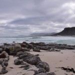
Lovers of shipwrecks and wilderness will enjoy the Shipwreck Trail (also called the Thomas T Tucker Trail, which has a nice alliterative ring to it) in the Cape Point Nature Reserve. Tami, Maria and I did it on one cloudy Saturday, close to low tide. (You can do the walk at high tide, but you won’t be able to get as close to the wrecks and some parts of the wreckage will be underwater.) The trail starts from the Olifantsbos parking area inside the reserve. There is a large sign saying THOMAS T TUCKER, which will send you on your way. A waist-high pyramid-shaped cairn of stones indicates where you must climb over the dunes onto the beach – the actual path is hard to discern at this point owing to fire damage.

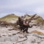
The path follows the coast past the Olifantsbos Cottage to the next beach, where the remains of the Thomas T Tucker are strewn around. Don’t rush past the beach outside Olifantsbos Cottage, though – there is a huge wooden log, bored by teredo worms, with rust marks at its base showing where it was attached to the deck of a ship or where fittings for lifting by crane were located.
It is possible that this is one of several hundred okoume logs that came off a cargo vessel called Lola in Table Bay in 2008. The ship was apparently in very bad repair. Similar logs can be found at Hoek van Bobbejaan, Sandy Bay, and other locations along the Atlantic coast. (Incidentally, those logs were predicted to cause havoc in the 2008 storm that uncovered the wreck of the Commodore II.)

On the beach near the Thomas T Tucker you will also see some whale bones, which are becoming more and more damaged with each passing selfie, but are still impressive in scale. I suspect that more of that skeleton is on display at the Buffelsfontein Visitors Centre near Buffels Bay in the park.

Continuing past the main wreckage of the Thomas T Tucker you will come across another small piece of rusty metal, which belongs to the same wreck even though it is so far away from the rest of the debris. Shortly you will spy the wreck of the Nolloth on the beach before you. Don’t overlook the rockpools on the way.

The route back can either be a retracement of your steps along the coast, or via the inland path marked by a sign on the edge of the beach just past the Nolloth. We struggled a bit to find the path as the plant life in the area has not recovered since the March fires, and in retrospect we’d probably have gotten on much better (and returned home much cleaner) if we’d just walked back along the beach!

You shouldn’t do any walking in the reserve without a proper map; my favourite is the Slingsby Map series. I got mine from the curio shop at Kirstenbosch, and they are available at most major bookstores (with a bias towards those in the south peninsula – I have seen them at both Wordsworth and at the Write Shoppe in Long Beach Mall). Be aware of and grateful for the baboons, don’t advertise your snacks, don’t go alone, and always take something warm with you even if it’s a sunny day when you set out.

In case you missed the links in the text, check out the separate posts on the two wrecks you’ll see along this trail: the Thomas T Tucker and the Nolloth.
If you’re interested in visible shipwrecks, check out my ebook Cape Town’s Visible Shipwrecks: A Guide for Explorers!


