In Malta we had the privilege of diving with several Russian divers, and Sergey our Divemaster was also Russian. They were extremely impressive in the water – precise, no wasted movements, and demonstrating exemplary buoyancy skills. Unfortunately their English was only slightly better than our Russian, so we had to rely on hand signals (and Sergey’s interpretations) to communicate.
A diver's version of grande battements
A couple of them also demonstrated some exemplary ballet/yoga skills, which were whipped out like clockwork between dives, despite still being clad in 5 millimetres of inflexible neoprene. I wonder whether maintaining a good in-wetsuit stretching regimen during the surface intervals wasn’t part of their secret diving mojo!
Streeeeetch...
These pictures were taken at Cirkewwa before and between dives on the Rozi and P29.
I’ve given a bit of an idea of the dimensions (epic) and history (tragic) of the Um El Faroud in my previous post about the wreck.When we dived her, Sergey obtained the prize parking spot at the bottom of the hill leading down to the water. He applied what he called a “Maltese handle brake”, in the form of a large rock placed behind one of the scuba bus’s rear wheels. Between dives we were able to relax on the jetty, pet the stray cats in the area, and observe the crowds of other (many local, but mostly British) divers also setting out for the wreck. The hill from Wied iz Zurrieq down to the sea is extremely steep (justifying the “handle brake” even on a car with all its mechanics intact) and we were grateful that our walk down to and up from the sea only involved a few steps. There’s a brilliant map of the entry point and the location of the wreck relative to the coast (and some stunning photos) here.
The anchor chain at the bow of the Um El Faroud
The reef adjacent to the Um El Faroud is a dive site in its own right, and we enjoyed very pleasant commutes along it on both dives we did. It drops off very steeply, so one can enjoy an interesting dive with an attractive, slowly decreasing depth profile (in other words, complete your safety stop without realising it!). The reef life is much the same as that observed at the Arch at Cirkewwa, for example, so I have focused on photos of the wreck here. One of the landmarks that shore divers use to locate the wreck from the reef is a commemorative plaque, in the form of a statue of an old diving helmet, that was placed just offshore, near the wreck, by the Atlam Sub Aqua Club.
Tony leaves the wreck
A fireworm near the funnel
The wreck is home to schools of damselfish
Tony heading towards a gangway
Tony swims over piping on deck
Tony at the bow
Laid back Sergey near the break in the wreck
Tony observes a barracuda near the bow of the Um El Faroud
Sergey swimming towards the bow in a cloud of damselfish
Sergey watches us from atop the funnel
The Um El Faroud was cleaned before scuttling, and there are multiple areas which are suitable for penetration. Tony took a brief swim inside (I’m not really interested in going inside a wreck at this stage of my life) – felt like forever before he emerged – and told me that once he entered the wreck he was amazed by the size of the interior, and the many passageways going off in directions that one could explore. There aren’t many tight spaces here, and apart from the (very real) potential to get lost inside and the cold water that settles inside the wreck, not too much to cause stress or discomfort to the careful diver. There is very little silt, and the waters around Malta are extremely clean. Significant amounts of daylight penetrate even to 20-30 metres.
AIr ducts
Top of the funnel
Rear view of the air ducts
Tony investigates the interior of the wreck
Tony sticks his head into a hole
Gangways along the length of the Um El Faroud
Tony investigates yet another hatch
Sergey and Tony on deck
Tony inside a large hole on deck
Legs are visible through a porthole
Sergey inside one of the exposed holds
Tony looking inside a gangway
We found this wreck to be an absolutely wonderful dive, and it completely justified the hype (I’d seen it given the accolade of “best wreck in the Med” more than once before our holiday started). The wreck is very large, and depth ranges from 35 metres on the sand at the rudder to about 18 metres on top of the superstructure. A reasonable level of fitness is required for the swim to and from the wreck, Nitrox is a distinct advantage, and obviously at least an Advanced or Deep qualification in order to get the full experience of the wreck.
Tony (foreground, with light) and Sergey on the bow of the Um El Faroud
Dive date: 5 August 2011
Air temperature: 31 degrees
Water temperature: 22 degrees
Maximum depth: 34.3 metres
Visibility: 20 metres
Dive duration: 49 minutes
The bow of the Um El Faroud
The stern of the Um El Faroud
Buckled railings
The propellor is still intact
The stern of the Um El Faroud
The bow of the Um El Faroud, with Tony and Sergey for scale
Our Malta diving holiday is a bit of a distant memory, and we’re closer to the next holiday than to the last one… But I can’t neglect to finish my series of posts about the dive sites we visited there. We dived several beautiful wrecks: the Rozi, the P29, the Imperial Eagle, and the subject of this post: the majestic Um El Faroud.
The anchor winch drum
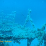
The Um El Faroud was a single screw motor tanker, built in 1969 in England and was owned by a Libyan transport company. She generally operated between Italy and Libya carrying refined fuel. In early February 1995 she was docked in one of the dry docks in Valletta, when an explosion occurred that damaged the vessel and killed nine dockworkers. The damage to the ship was sufficient to render it a write-off. It was decided – after she had languished in the docks for three years reminding all and sundry of her tragic past – to scuttle the Um El Faroud to make an artificial reef. She was duly sunk in September 1998, on the sandy bottom to the south west of Wied iz Surrieq, a small village on the south coast of Malta. This was an absolute stroke of genius, and she is now one of the most famous wreck dives in the Mediterranean.
Explosion damage, where the wreck snapped in two
After a bad storm in winter 2005-6 the ship broke in two pieces, around the location of the original explosion damage. The two pieces of the ship are slightly offset from each other.
Railings, with the crane below
Gangway and upper superstructure
Torn edge of the deck, amidships
Buckled metal at the site of the explosion that damaged the Um El Faroud
Hatches and bollards on deck
Winch drum on deck
Hatch and ladder on deck
Entrance into aft superstructure
Damage from the explosion
Wreckage inside the part of the hold
The jagged edge of the deck where the wreck split in two
A crane on the Um El Faroud
The Um El Faroud measures about 110 metres in length, with a beam of 15.5 metres. From funnel to keel she is about 25 metres high. The wreck is too large to explore in a single dive, so we did two dives on her in succession (on Nitrox). After that we still don’t feel that we’ve got a grasp of the wreck, but until we move to Malta and dive her weekly, it’ll have to do!
The broken edge of the wreck where it split in two
The wreck is located close to a tourist attraction called the Blue Grotto, and the entry point for the dive is in a narrow channel used by pleasure boats transporting tourists to the Grotto. She is accessible via an easy shore entry: giant stride in, ladder out. It’s a swim of about 200 metres from the inlet to the Um El Faroud. Tony and I were absolutely gobsmacked that a vessel of this size could be so easily accessible without having to charter a dive boat.
The ladder by which we exited the water
Tony crossing the inlet at Wied Iz Zurrieq
A fireworm in the shallows
Tony climbs out of the water after the dive
Sergey gives Tony (who is reluctant to get out of the water) a hand
A boat passes overhead in the narrow inlet close to the Blue Grotto
At times strong longshore currents sweep over the wreck, and it’s important to be aware of these so as not to overexert or get swept off the wreck. The second time we dived the Um El Faroud such a current had come up, and under Sergey’s guidance we simply took the most direct route to the drop off against the coast, and swam back that way to avoid having to labour into the current on the return leg of the dive. There is very useful information on this site in Peter Lemon’s book on diving in Malta.
A fireworm on a railing
Crane and damselfish
Damselfish swarm above a hatch
Damselfish in front of the funnel
Hatch on deck
Damselfish in front of the funnel
Damselfish on deck
Sergey perches on top of the funnel
This isn’t really a wreck you dive for the marine life, but more for the incredible privilege of exploring such a large structure in three dimensions. It’s possible to penetrate the wreck (with appropriate training), and even dropping into one of the open, exposed holds gave us a taste of how cold the water inside this great big refrigerator can get! In the next post I’ll provide some more wide angle photos of this wreck.
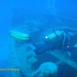
We did two dives on the P29, one with Sergey and a group of Russian divers, and one with Publio and two Maltese divers (Stephanie and Joseph) who now live in Ipswich, where the water pressure is apparently quite good!
Top of the P29’s mast
The crows nest of the P29
Tony swims far ahead of me onto the P29
The masts of the P29
Forward mast
Mast and crow’s nest of the P29
Damselfish swarm around the mast
The bridge and superstructure of the P29
The stern of the P29 stretches out ahead
The bridge of the P29
The visibility we experienced during the four dives (the other two were on the Rozi) we did at Cirkewwa was the best of all the locations we dived around Malta, showing off the wrecks there to their best advantage. The light penetrates sufficiently that posodonia grows right down to 30 metres.
Tony checks out the superstructure of the P29
Bridge of the P29
Tony inside the hold
Tony filming something inside the wreck
Bridge of the P29
Open hatch on the deck
Superstructure of the P29
The hatches and doors on the vessel were removed before it was scuttled, and penetration of the wreck is possible. We did not go into any overhead environments, but dropped down into one of the holds which is open to the sea (and as cold as a refrigerator). We also stuck our heads into lots of dark places!
Looking up inside the large open hold
Joseph examines the contents of the P29
The view down into the ship
Tony checks out a hatch
Joseph checks out an open hatch
Tony squeezes himself in a doorway
Tony takes a look inside
Lots to see inside the hold
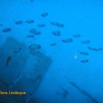
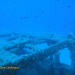
The P29 is not actually that large (53 metres long, 7 metres wide), but somehow seems quite imposing as it stands on the sand. Its relatively small size meant that we could explore it entirely in a single dive. When we took a tour of the Grand Harbour in Valetta, we were able to see some of the other patrol boats that the Maltese Armed Forces use to police their territorial waters.
The P29 is a Kondor Class former Minesweeper for the East German Navy, and was later a Patrol Boat for the Armed Forces of Malta. The P29 is 52 metres long and 7 metres wide, with a 2.3 metre draft. She was powered by twin diesel engines, had a maximum speed of 20 knots, a crew of 20, and weighed 361 tons.
The bow of the P29
The bow of the P29 from above
Tony at the bow, on the sand
The stern of the P29
Saddle bream school on the wreck
Tony filming the bow of the P29
The bow of the P29
Sergey hangs above the stern of the P29
Sergey and Tony swim into blue water in search of the P29
The scuttling of the P29 was spearheaded by the Malta Marine Foundation, as an artificial reef and as an attraction for recreational diving. She was scuttled in August 2007 just off Cirkewwa. She is located close to the tugboat Rozi, 170 metres offshore, and the same entry point works for both wrecks. She sits upright on the sand at 33-35 metres. The top of her mast is at about 14 metres, with the top of the bridge at about 20 metres.
A mast rising next to the bridge
View up the mast
Tony investigates the superstructure
The crow’s nest on the mast
Tony on the bridge, under the mast
Top of the mast
Saddle bream in front of the bridge
Railings behind the bridge
Upright structure next to the bridge
Divers investigate the mast of the P29
Before scuttling, the P29 was cleaned, and all doors and hatches were removed. Penetration is safe – there is no silt, and the entrances are evident. The clarity of the water means that finding the source of natural light is relatively straightforward.
Divers swimming off the reef towards the P29
Divers swimming off the reef towards the P29
Hermit crab in an air duct
The entry is via Susie’s Pool, which we used when diving the Rozi.
Divers setting off down the wall to the sand
Rock at the seaward entrance to Susie’s Pool
Tony interacting with a rainbow wrasse
Posodonia and algae in shallow water
Entering the water at Susie’s Pool
Investigating a crack in the limestone
Boulder looks precariously balanced!
Degassing in shallow water
Tony investigating the shallows
The shallows of Susie’s Pool
Bright sunlight, clear water
Tony swimming towards Susie’s Pool in the shallows
Exiting the water at Susie’s Pool
Dive date: 2 August 2011
Air temperature: 31 degrees
Water temperature: 23 degrees
Maximum depth: 31.9 metres
Visibility: 30 metres
Dive duration: 48 minutes
Leaving the P29, the stern is visible for ages
The back of the P29 extends shoreward
Crows nest
The bridge of the P29
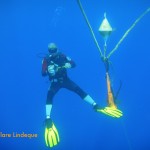
Sergey used this “table” to do deep skills on with an Advanced student
The Blue Hole is a sinkhole or collapsed cavern in the limestone at Dwerja near San Lawrenz, on Gozo, one of the three islands that make up Malta. It’s about 10 by 5 metres, and the entry point is reached via a slightly rough (but not too bad) walk over the rocks. There are stairs and handrails in places, as this is a spot heavily frequented by tourists and divers. A shallow pool with quite a knobbly bottom surrounds the Blue Hole on the landward side, and we staggered across that and flopped into the Hole itself to put on our fins.
DIvers on the surface of the Blue Hole
My handsome husband descends into the Blue Hole
Swimmers on the surface of the Blue Hole
A swimmer descends past the arch
The surface and walls of the Blue Hole
Surface of the Blue Hole, from below
The inward side of the arch leading out to sea
The rim of the Blue Hole
The shallows at the edge of the Blue Hole
Descending into the Blue Hole is magical – almost as soon as you submerge, an arch stretches across before you, opening the side of the Blue Hole out to the open ocean. The view is spectacular whichever way you look. We spent some time admiring the sunlight filtering down into the hole, and then swam under the arch and out into the open sea.
Tony in a narrow gap
Bubbles rise through the limestone
Tony on the wall
Tony swims toward a cloud of damselfish
The wall drops off to over 50 metres
Cracks in the reef are fun to swim through
Tony taking footage as he swims backwards out of a cave
The wall drops from the surface
The wall rising to the surface
Rocky outcrops
Dramatic limestone landscape
Tony swimming above me… His bubbles the only evidence he’s in water
The dive was through what we by then recognised as typical Maltese limestone reefs, with eel grass, posodonia, and a host of sponges and sea plants covering boulders and valleys that resemble a terrestrial landscape. The highlight of this dive (and perhaps of the trip) was encountering a bluefin tuna, who spent nearly half an hour following us and swimming into our faces. I felt so moved that I became annoyed with the confined feeling I was suddenly experiencing in my mask and regulator – I wanted to share this with someone, discuss it, laugh at how he made munching movements with his mouth every time he came near us, and lament at how lonely he seemed.
A school of salema fish above the reef
The tuna swimming away from Tony
Tony filming the bluefin tuna
Tony and the tuna
Sergey and Tony, after the exit of our tuna friend
The tuna, and Sergey in the background
The Azure Window on Gozo
Next to the Blue Hole is the Azure Window (Tieqa Żerqa in Maltese). It is a natural flat-topped arch, about 23 metres high. The arch is apparently slowly disintegrating, with pieces of limestone frequently falling from it. It is expected that in a few years the arch will be gone, and we will be left with the Azure Pinnacle. We swam back under the Azure Window at the end of our dive. I must admit I didn’t realise we were doing that at the time! It’s a spectacular piece of scenery.
Negotiating a narrow swim through
Light penetrates a cavern
Tony disappears down a hole
The inside of a tunnel in the reef
At the base of the Blue Hole is a dark cave, which we briefly explored (we were a bit low on air so neither of us wanted to go too far in). There are convenient ledges and lots to look at around the five metre mark to do a safety stop. We were entertained by watching snorkelers from beneath, and other divers outside the arch leading to the open sea, as we degassed.
Divers on the surface of the Blue Hole, seen from inside the cave at the bottom
The surface of the Blue Hole, from the bottom
Bubbles rising in front of the arch
The edge of the Blue Hole, with the arch to the right
Swimmers in the Blue Hole above the arch
View out to sea, under the arch, from inside the cave
Cardinal fish inside the cave at the bottom of the Blue Hole
Of the ten dives we did in Malta, two were boat dives, done consecutively on one of the days. Our diving companions were all Russian, which meant that Sergey gave us our own personal dive briefing in English, and then switched to more stentorian tones to deliver the Russian version, with the assistance of Peter G. Lemon’s Malta diving book. The first of our boat dives, which were done in such style and comfort that we did not want the day to end, was to the Imperial Eagle, a small ferry that was deliberately scuttled as a diver attraction.
The ship’s wheel is still in place
The Imperial Eagle is 45 metres long, 9.2 metres wide, and was 257 tons, powered by two oil engines. She was first launched in 1938 in England. The Imperial Eagle was a car and passenger ferry that could accommodate 70 passengers and 10 cars. Her maiden voyage between Malta and Gozo was in 1958, and she continued on this route for ten years. Afterwards she was used to transport cargo and animals between Gozo and Valletta.
The bow of the Imperial Eagle
The stern of the Imperial Eagle
The wreck is slightly broken up in parts
The bow of the Imperial Eagle
Tony at the wheel
View of the bow from the superstructure
Broken railings
The wheel on the bridge
Tony swimming over the wreck
In 1995 she was sold to the local diving community, and was scuttled 500 metres off Qawra Point in 40 metres of water on 19 July 1999. The intention was that the vessel would form the main attraction in an underwater marine park. The vessel is colonised by large numbers of fish, who take shelter around it rather than trying to hide in the exposed, crystal clear waters around the ship.
Divers on the surface after dropping into the water
The propeller and rudder of our diveboat
The ladder for exiting the water
Tony next to the buoy line
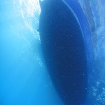
The underside of our dive boat
The visibility was almost top to bottom
Divers above us, doing their safety stop
Knot in the buoy line – not much growing here
Tony – neutrally buoyant
Tony passes over sea grass near the buoy line
We dived the Imperial Eagle off a traditional Maltese boat called a luzzu.Boat diving in Malta is done off a variety of vessels (basically, anything that floats!) but we were very charmed with the colourful hull and spacious accommodations of our boat for the day. Entry into the water was via a giant stride, and to exit one removes one’s fins and climbs up a small ladder on the side of the boat. The boat moves very slowly, and our surface interval was spent driving to L’Ahrax Point, location of our second dive that day.
A traditional Maltese boat, used as a dive boat
One side of the wreck
Saddle bream down the side of the wreck
Tony is surrounded by damselfish as he passes over the wreck
Saddle bream in motion
Saddle bream on the wreck
Storage compartments now open
The wreck is lightly encrusted
Funnel of the Imperial Eagle
The bow of the Imperial Eagle makes her appearance
There is a permanent buoy close to the wreck’s location, and on the way to the wreck one swims past the statue of Christ, located in a natural stone amphitheatre. The wreck is quite deep, and we did notice a distinct set of thermoclines as we descended. Since the coldest of these took us to a water temperature that is more or less the warmest we usually experience in Cape Town (and that usually coupled with Pronutro visibility), we weren’t fussed. Nitrox is an advantage on this site, and we used 32%. The wreck is of a very manageable size to see in a single dive, and is fairly intact but showing signs of her age.
On one of the days we spent diving in Malta we did two dives on the island of Gozo, accessible from Malta by using the car ferry at Cirkewwa. The diving on Gozo is wonderful, and there are dive centres located on this island even though only about ten percent of the 500,000-strong Maltese population resides here (the rest are on Malta, with four lonely souls on Comino). GozoDiver has more.
The entrance to the tunnel that leads to the open sea
Sign showing the layout of the Inland Sea and tunnel (excuse the large finger on top)
Algae growing inside the tunnel
The Inland Sea is a small, shallow (maximum 2 metres deep) body of water on Gozo at Dwejra Point, linked to the open sea by an 80 metre long tunnel through the rock. The Inland Sea itself is about 60 metres wide and is fringed by fishermen’s huts and a cafe or two. The tunnel is about 3 metres deep at its entrance on the Inland Sea, and drops to about 26 metres by the time it reaches the ocean.
The top of the wall, and the surface
Sergey checks that we’re still with him
Tony, Sergey and the Russians heading through the tunnel towards the sea
The vertical wall of the tunnel, and the surface
The light of the open sea appears at the end of the tunnel
The tunnel opens onto the sea
Tony’s light illuminates the wall of the tunnel
Large rocks on the tunnel floor, dislodged during storms
We emerge from the tunnel into the ocean
Sergey finning backwards along the wall
The wall outside the tunnel is overgrown with algae and seaweed
The wall drops off to 45-50 metres
Getting across (or through) the Inland Sea to the entrance of the tunnel was a bit uncomfortable – we entered the water next to a small jetty and put our fins on, but it was too shallow to swim and the rocks on the bottom were of an inconvenient size (like melons) and texture (slippery) for walking over. A slow backstroke punctuated by occasional ringing sounds as my tank struck a rock was the order of the day.
Divers heading out to sea
The tunnel and Inland Sea are used by pleasure boats which take tourists through the tunnel, and out into the ocean to see the Azure Window and surrounding coastline. While it’s an overhead environment in the sense that there’s a solid sheet of rock above one’s head, it’s possible to surface in the tunnel (provided one watches out for boats and stays near the sides). We descended at the entrance of the tunnel, straight into several metres of water. As we swam further into the tunnel the rocky bottom cleared to leave a sandy path down the middle of the tunnel. The tunnel slopes downward as one approaches the ocean.
A white tufted wom (Protula tubularia)
I found swimming through the tunnel to be an absolutely mind boggling experience. The blue of the open sea ahead is profound and draws one on through the darkness, and the warm water is incredibly comfortable. It was the kind of place where one can almost hear an imaginary soundtrack of some kind of celestial muzak. I felt that after having this experience I could die, happy. I also felt that this must be what heaven looks like (honestly – I could have stayed in that tunnel forever). But I didn’t die (of happiness) – the end of the tunnel brought us out onto a wall that dropped down to 50 or 60 metres.
Schooling salema fish
Sergey heads towards a school of salema fish
The wall drops to 50 metres in places
Tony and a cloud of damselfish on the wall
Distant Tony, and damselfish
Saddle bream, and disappearing divers
Saddle bream on the wall
Tony cruises along the wall
A fireworm (Hermodice carunculata) inside a cave
We took a long swim along the wall, at varying depths – we probably moved between 25 and 10 metres, following the contour of the outcrops and gullies. There were some weird horizontal thermoclines that manifested themselves visibly as well as through my wetsuit. Shimmering walls of water up ahead indicated a drop (often brief) in temperature. I’m not sure if these weren’t maybe spots where fresh water was seeping out into the sea through the limestone rocks.
Emerging from the vertical tunnel
Tony’s light illuminates the tunnel ahead of me
Swimming out of the tunnel
Tony moving over the sea grass outside the tunnel
Just prior to this dive, Divemaster Sergey asked me in an offhand manner if I was claustrophobic. I replied in the negative, and thought nothing of it until he swam us through a 15 metre vertical tunnel in the rock, just wide enough to accommodate an average-sized diver. The tunnel opened up at about three metres’ depth, and a letterbox type arrangement allowed one to exit. I found this to be quite an intense experience, and was rather impressed with myself afterwards for swimming through the tunnel without batting an eyelid. I don’t have any cavern or cave training (and don’t actually think I want any – open water diving is fine for me!) but there was something wonderful about the caves and holes we swam into in Malta that helped me to understand the allure of overhead environments to braver folk than I (such as Cecil!).
Tony swims above me
We made our way back along the wall and into the tunnel, reversing our route to return to the Inland Sea. Just before the entrance to the Inland Sea we made a safety stop among huge blocks of limestone that have fallen from the ceiling of the tunnel. There was a lot of life here – colourful seaweeds, algae, corals and sponges, and some shy invertebrates who hid from Tony’s video light and my torch.
A fireworm inside the tunnel
There was quite a lot of swimming involved in this dive, and it was fairly demanding both physically and mentally. Obviously Sergey had decided what dive plan we’d follow based on what he’d learned of Tony’s and my air consumption and water skills in the five dives we’d already done under his guidance, and the options for routes and dive plans here are endless. Peter G. Lemon’s book on scuba diving in Malta lists a few of the options, and additional dive plans can be devised from the maps he provides.
Dive date: 4 August 2011
Air temperature: 32 degrees
Water temperature: 24 degrees
Maximum depth: 25.2 metres
Visibility: 35 metres
Dive duration: 53 minutes
Algae and invertebrate life inside the tunnel
Tony safety stopping near the end of the tunnel in the Inland Sea
The Inland Sea is ahead as we return through the tunnel
Large rocks have fallen from the tunnel’s roof to the seafloor
Rocks on the seafloor in the darkness of the tunnel
The tunnel joining the Inland Sea to the open ocean is full of beautiful plant life
The arch at Cirkewwa is located to the northwest of the lighthouse there, along the edge of the reef running along the coast. It is in fact a cavern whose roof is open (perhaps due to a long-ago collapse), with the arch across the entrance. The surrounding reef is covered with sea grass and posodonia beds.
The arch in the distance
Tony filming the arch
The midsection of the arch
Looking out from inside the roofless cavern
Algae, posodonia and sea grasses are abundant here
Cirkewwa arch
Bubbles and the arch
Bubbles rising through the porous limestone
Damselfish and rainbow wrasse among percolating bubbles
Bubbles on the reef
Rainbow wrasse looking for food among the algae beds
Damselfish (and a rainbow wrasse in the foreground)
Tony examining the top of the arch
Tony swimming along the top of the Cirkewwa arch
The drop off to deeper water makes for a lovely wall dive
The top of the arch is at a depth of about 12 metres, and the sand below is at about 20 metres’ depth. The rocks of which the Maltese islands are formed is mainly limestone, which is quite porous and has a tendency to form caves, holes and crevasses (all of which are enjoyed by divers). We loved watching the tiny bubbles coming through the rock – when divers swim under ledges and into caves, the air bubbles from their exhalations find their way straight through the rock.
Damselfish over the sea grass
Schools of fish on the reef
Entering the shallows, sunlight penetrates to a ridiculous degree
Tony investigates
On the left is a swim-through under an arch in the reef
Another natural arch in the limestone reef
The sea grass looks like seahorse country
Tony swims toward home in a cloud of bubbles
The damselfish enjoy edible items dislodged by rising bubbles
Bubbles, sea grass and damselfish
Bubble curtain rising through the limestone rock
Tony swimming along the edge of the reef
Tony checking out one of the many holes and swimthroughs on the reef
We only spent part of the dive at the arch, and the swim from the arch back to the exit point is extremely scenic. I’ve included a number of photographs of the reef, which is representative of all the reefs around Malta.
We found this tag from the University of Malta on the shallow part of the reef
The swim back to Susie’s Pool from the arch is quite long, and along a wall for most of the time. One can choose the depth to swim at – since the water is so clear, the only material consideration is air consumption. Under the wall are many overhangs, and there is rich plant growth and fish life from top to bottom.
Another mini-arch that we were able to swim through
Tony over beds of algae
The remains of some kind of bivalve attached to the reef
Tiny damselfish and a saddled bream
There is rich plant growth into quite deep water, owing to the clarity of the sea in Malta
Tony on the wall at Cirkewwa
A curtain of bubbles from divers below us
Approaching Susie’s pool, our exit point
Red mullet feeding in the shallows
The arch can be dived as a dive by itself (the depth and warm water allowing a long stay!) or, as we did, on the way back from a dive on the tugboat Rozi (hence the maximum depth shown below).
Dive date: 6 August 2011
Air temperature: 31 degrees
Water temperature: 20 degrees
Maximum depth: 34.0 metres
Visibility: 30 metres
Dive duration: 60 minutes
Divemaster Publio swims back to the entry/exit along the wall at Cirkewwa
Maltese waters (the Mediterranean Sea) are warm and have almost no plankton, and the resulting biomass of fish and invertebratelife supported here is much lower than in our nutrient rich Atlantic Ocean. There are, however, some impressive large visitors such as barracuda and bluefin tuna (many of them – I think – escapees from local fish farms). Most of the other fish are wrasse – many of which would blend in wonderfully in Sodwana! – and bream.
Barracuda (Sphyraena sphyraena)
We found concentrations of fish life in the shallows (five metres of water or so), and on the many wrecks that we dived. It was strange swimming to the wrecks, however, over featureless white sand, with not a fish in sight. Sometimes we would swim through a veritable cloud of damsel fish (Chromis chromis) – the juveniles are a beautiful indigo colour and impossible to photograph, hence their absence here.
Red scorpion fish (Scorpaena scrofa)
Two banded sea bream (Diplodus vulgaris)
Ornate wrasse (Thalasoma parvo)
Red mullet (Mullus surmuletus)
Damsel fish (Chromis chromis)
Painted comber (Serranus scriba)
Parrot fish (Sparisoma cretense)
Saddle bream (Oblada melanura)
Pilchards (Sardina pilchardus)
Salema fish (Sarpa sarpa)
Cardinal fish (Apogon imberbis)
Rainbow wrasse (Coris julis)
Tompot blenny (Parablennius gattorugine)
Black sea bream (Spondylisoma cantharus)
Ring necked blenny (Parablennius pilicornis)
Long snouted wrasse (Symphodus rostratus)
Peacock wrasse (Symphodus tinca) – male
Peacock wrasse (Symphodus tinca) – female
Bluefin tuna (Thunnus thynnus)
Most of the fish here I identified with the help of Peter G. Lemon’s book, Scuba Diving Malta – Gozo – Comino, and Lina of Subway Scuba in Malta also helped enormously.


 and Sergey on the bow of the Um El Faroud")


")


")


")
")