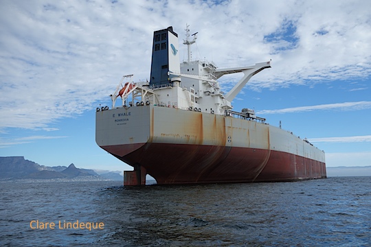
On our way back from Big Bay, we took a slightly roundabout route to OPBC, passing some of the ships that were anchored offshore in Table Bay. Ships anchor here when they are waiting to enter the harbour, but some also stay for longer periods of time, in order to effect repairs, or because they cannot continue further. E-Whale, a bulk carrier about which you will hear a bit more next week, has been here for over two years.
Bulbous bow of E-Whale
E-Whale has a bulbous bow that looks as though it’s been in a bit of a scratching fight! She is a very impressive ship from close up, even though by bulk carrier standards she is only middle-sized.
E-Whale
On the way back into OPBC I marvelled at the piles of dolosse that protect the slipway and jetties there by dissipating wave energy. These are a South African invention that were inspired by the children’s game of jacks, and are used in harbours around the world. The ones in the picture below aren’t the typical shape, but triangular.
Seahorse at OPBC
Because our swimmers had arrived last, and we took a scenic route back to Granger Bay, we had lots of space to take the boat out of the water when we arrived. The slipway was far more congenial and orderly than we’re used to experiencing – wonder why?
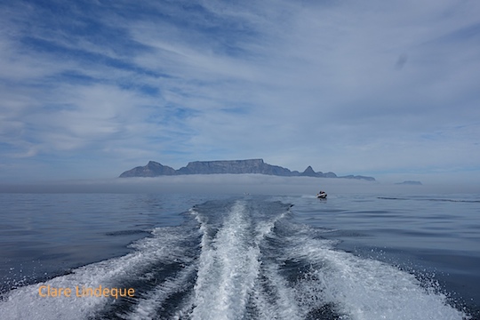
The swimming part of the Freedom Swim took a while. Our swimmers completed the 7.5 kilometre stretch in just over three hours, so we were moving at 2-3 kilometres per hour most of the time. I kept an eye on the swimmers, and Tony kept the course correct. We were at the back of the group of swimmers, so up ahead we could always see the other boats. Some of the swimmers (in white caps) were doing relays, so there were regular sightings of skippers hauling freezing participants onboard, and others leaping off into the ocean to continue the swim.
Boats up ahead
Handing the swimmers over to Big Bay lifesavers
The finish at Big Bay
Rocks at Big Bay
Distant tanker
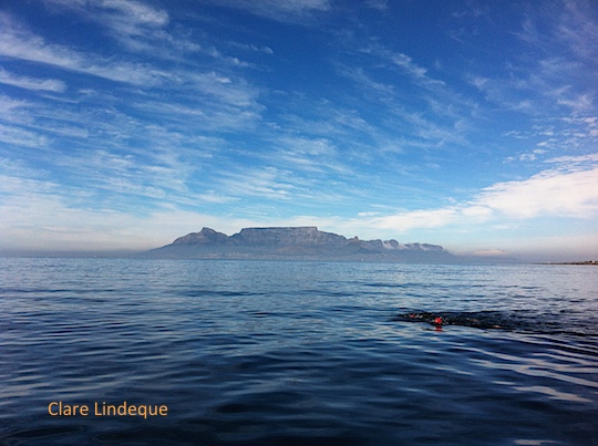
Swimmers in Table Bay
E-Whale in the distance
Heading towards Big Bay
Three swimmers before Table Mountain
Our three swimmers set off
Once we got to Big Bay, we guided the swimmers between the rocks and handed them over to the local lifesavers, who guided them to the beach and assisted them through the surf. Once they were on dry land, there were immediate medical checks, an afterparty, and prizegiving. Tony and I headed back to Granger Bay in the stiff breeze that was building, with a slight detour…
One of the most enjoyable parts of the Freedom Swim (from Robben Island to Blouberg, on May 3rd) was the time we spent waiting outside Murray’s Bay Harbour on Robben Island, where the swim was to begin. Once we received the all-clear to head from Granger Bay to the island, we saw that the mist only extended a short distance out to sea, and it was clear at Robben Island.
Table Mountain and Robben Island
A motley assortment of boats – from a huge yacht to a two metre long rubber duck with a single 15hp motor, as well as some rescue boats, stand up paddle boarders, and kayakers – spent nearly an hour bobbing gently on the mirror-like ocean.
Waiting for the swim to start
A festive atmosphere prevailed. In order to assist their swimmers to identify them, boats were adorned with flags, balloons, inflated papsakke, towels, and other colourful items. Stand up paddle boarders moved through the crowd of boats, and we enjoyed a strange stereo effect when radio announcements were made by the organisers.
A tanker is visible in the distance
Clouds above the calm sea
An assortment of watercraft
The expensive, fancy Robben Island ferry is broken (as it seems to have been almost since the moment it went into service), so Nauticat, the seal watching boat from Hout Bay, is doing duty as one of the ferries bringing visitors to the island until a new ferry is obtained. The ferries practically handbrake turn into the harbour when they arrive, slowing down not at all, so there was a delay at the start of the swim while we waited for a ferry to complete its arrival.
The Robben Island ferry stand-in, Nauticat from Hout Bay, approaches
We could hear the countdown over our VHF radio for the start of the swim for participants wearing swimsuits, and about half an hour later the wetsuit swimmers hit the water. They started inside the harbour, so it was a few minutes before the first swimmer emerged from the harbour entrance and headed for the buoy that marked the start of the course.
Many small craft waiting for the swim to start
Once we had rendezvoused with our three swimmers, we were off! (Swimming happens at a pace close to walking speed, so we trawled along with just one motor at a time.)
Cranes and boats at the V&A Waterfront, half hidden by mist
The Freedom Swim series is a series of timed open water swims around the Cape Peninsula. Tony provided support to three swimmers who planned to complete the 7.5 kilometre swim from Robben Island in Table Bay, to Big Bay on the Blouberg coast. The day started extremely early, as I went to meet the swimmers at the V&A Waterfront at 0700 while Tony launched the boat at Oceana Power Boat Club.
Cape Town Stadium shrouded in mist
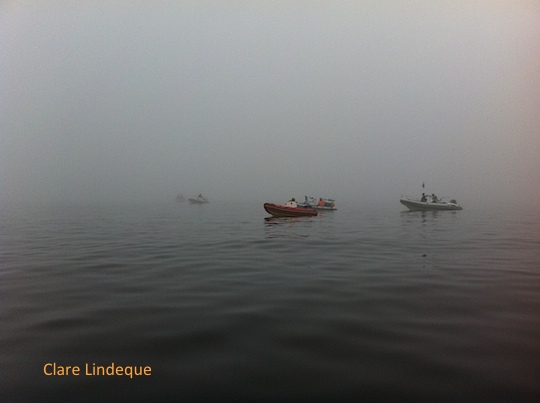
Once I’d collected the swimmers’ gear, refreshments and warm clothes, I went to meet Tony in Granger Bay. There was a thick mist over the Atlantic seaboard, and all the boats who were helping with the swim were drifting on the flat sea just outside OPBC. It took a long time, but when the mist started to clear we could see Cape Town Stadium looming over us.
Tony waiting for the mist to clear
We did a lot of standing by to stand by, and then we did some standing by. It was very quiet in the mist!
Other boats wait in the mist
At about 1030, after waiting for several hours, we got the go-ahead to set a course for Robben Island. Tony enjoyed testing the motors on Seahorse, as they’ve recently been changed. (And yes, we did get to the island first.)
Robben Island
The meeting point and start of the swim was Murray’s Bay Harbour on the eastern side of Robben Island. The swimmers were to start in two groups: the first swimmers would be in swimsuits (and Vaseline), and the second group, which included our swimmers, would be in wetsuits. We had numbers corresponding to our swimmers attached to the side of the console.
A blanket of mist below Table Mountain
I loved seeing Table Mountain from the sea. What I particularly liked is that the strip of mist below the mountain hid all signs of human settlement (including Cape Town harbour and the abominable Disa Park towers, but excluding the cable station), which let me imagine what this place might have looked like to early visitors to Table Bay.
Motoring out to Robben Island – looking back at Table Mountain
Tony provided support to some swimmers who participated in the Freedom Swim from Robben Island across Table Bay to Big Bay, on 3 May. We launched at Oceana Power Boat Club, and motored across to Robben Island when the mist cleared a bit, enjoying the excellent power to weight ratio that the boat now has thanks to the 60hp Mercury four strokes that Tony fitted recently.
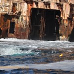
One Sunday in early April, Tony did a very early launch for an Aquaventures PADI IDC, taking the divers to the wreck of the BOS 400 and to dive with seals at Duiker Island in Hout Bay. You can see in the photo above that the sun hasn’t even reached Maori Bay as the divers kit up! The visibility on the BOS 400 was about six metres, and it was about eight metres at Duiker Island. At the wrecks inside Hout Bay (the Aster and Katsu Maru), there were reports of visibility of up to 15 metres.
The BOS 400
Rusty hull of the BOS 400
Close up of the BOS 400
After the early launch, Tony and I took the boat for a drive south towards Cape Point. We weren’t in a rush, partly because we needed to run in the boat’s motors gently, and so we stopped to look at the scenery.
Chapmans Peak drive
Chapmans Peak
Door in the cliff
Rocky cliffs along Chapmans Peak
Chapman’s Peak Drive is carved out of the mountainside at the intersection of the Cape granite and sedimentary layers (geologists love this fact), and this can be seen clearly in areas where the mountain isn’t highly vegetated (such in as the photo above). Tony showed me a strange “door in the cliff” – a neat rectangular opening (it seems) that looks like it should be in The Hobbit. You can’t approach it closely on a boat because there’s foul ground in front of it, and the sea is turbulent even when there’s not much swell.
Sea spray on Long Beach, Noordhoek
Long Beach is long. There were lovely big waves, with spray unfurling from their tops in the light breeze. We could see horse riders on the beach, surfers in the swell, and at one point right across False Bay to the Hottentots Holland and Hangklip. Further down, the boiler of the Kakapo shipwreck was clearly visible on the sand.
Calm seas to Hout Bay
Slangkop lighthouse
Standing in the bow
Big waves rolling in near the Kakapo
Tony on board
View across False Bay from the Atlantic
Idle near a small kelp forest off Long Beach, Kommetjie
Slangkop lighthouse (pardon the blurry photo) is being painted, it seems – the building is completely clad in scaffolding. This was our turning around point, but first we had coffee and a snack. Boating makes you hungry!
Slangkop lighthouse getting a facelift
On the way back we stopped a few times to look around (Tony was looking for a whale shark, after NSRI report from St Helena Bay the previous day, and unconfirmed sightings of one in Kommetjie) and dangle our (ok, my) feet in the freezing water. There was an offshore wind blowing. In places the air was freezing cold, and in others the hot wind, smelling strongly of fynbos, made everything wonderfully pleasant.
Clean water and kelp near Duiker Island
The Sentinel
Cormorants near Duiker Island
We took a drive across the mouth of Hout Bay to Duiker Island, where the water looked quite clean. There were snorkelers in the water with the seals. I drove us back from the island (slowly) – I don’t have a skippers licence yet, and in order to get one I need (supervised) hours on the boat. So this was practice.
The Seal Alert boat is in disrepair
Napping on an outboard
Seal ready to go to sea
Once inside Hout Bay harbour, we milled around a bit waiting for the slipway to clear (some poachers were launching, amongst other activity). We came across the Seal Alert boat, which has sunk into disrepair but is a very enjoyable resting spot for some of the local seals. There are also a few boats that have sunk at their moorings – apparently because their drain plugs were stolen.
Boat out for repair at Hout Bay harbour
Half sunken in Hout Bay harbour
Promising wreck dive in the harbour?
Derelict ships in Hout Bay harbour
Fishing vessels moored in Hout Bay
Divers going out from Hout Bay
The middle (bright green) ship in the picture of the fishing vessels moored in the harbour in the above gallery of images, is the sister ship of a ship that ran aground off Betty’s Bay in February, breaking up and spilling huge amounts of fuel near the vulnerable penguin colony.
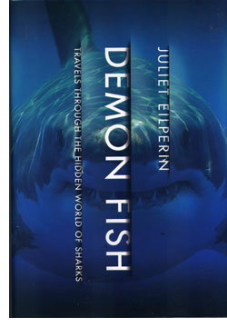
Reading this so close to Thomas Peschak’s book Sharks and People made for an interesting juxtaposition of two books that are both concerned with similar subjects. Peschak makes his interest in the relationship between humans and sharks explicit in the title of his book, and goes on to explore it in a primarily visual manner.
Juliet Eilperin is an environmental reporter for the Washington Post, and despite the singular focus of its title, her concern in Demon Fish seems to be similar to Peschak’s: sharks and people. I’m not sure if this is because, as an outsider to the world of shark research, shark diving, and shark conservation she had couldn’t but focus on the human element of sharks’ existence, or whether it was a deliberate tactic.
Whatever the reason for the book’s focus, this is actually a very good introductory volume to give to someone who doesn’t know much about sharks, and who may not understand the conservation concerns surrounding them. This is not a scientific volume, and may disappoint shark fanatics who purchase it expecting to be enlightened on shark biology. Eilperin provides some facts about a few of the better known (read: more charismatic) species of shark, but the bulk of the book comprises interviews with shark scientists (such as Neil Hammerschlag, Alison Kock, Sarah Fowler, and Barbara Block), fishermen, activists (including seriously legitimate ones like Sonja Fordham), and Asian players in the shark fin trade.
Eilperin dives with sharks in the Bahamas, eats shark fin soup, and travels the world putting together a picture of sharks’ role in local economies – the lucrative fin trade, whale shark tourism in Belize, cage diving in Gansbaai, South Africa – and in human culture. After visiting a shark caller in Papua New Guinea, she traces the history of the 1916 shark attacks along the North Atlantic coast of the USA that did so much to shape our modern perception of sharks, and interviews Jaws author Peter Benchley’s wife (he is deceased). An analysis of efforts to mitigate human shark interactions, lead her to Cape Town’s Shark Spotters program, the Shark Shield device (formerly Shark POD) and the indiscriminate shark mitigation program of the KZN Sharks Board. The acknowledgements at the end of the book read like a who’s who of shark researchers and conservationists (including the venerable Eugenie Clark). Ms Eilperin’s research was thorough!
The book seems to have been reprinted as Sharks: Travels Through a Hidden World in the United Kingdom. I prefer this title, as Demon Fish seems a little bit exploitative and sensational, particularly given the fairly benign nature of the book’s contents. There is a detailed and fascinating review of Demon Fish at the London Review of Books, an interview with Eilperin here, and a very short interview with her here.
Buy the book here if you’re in South Africa, and here if you’re not. If you want to read it on your Kindle, go here.
This is a citizen science project in the best sense. Four web-based atlases, each focusing on a particular type of marine life, are being established, with contributions from researchers, students, and people like you and me – mostly recreational divers, who get to see firsthand what lives underwater. The four atlases are:
The primary platforms on which these observations will be collected are iSpot (we reported our Western leopard toads there when we moved to the South Peninsula in 2012), SAJellyWatch, and EchinoMap.
There is also a section of the database for historical photographs of fishing activities prior to 1970. This will assist in establishing a baseline from which changes (that we have wrought, mostly) in the abundance and distribution of fish species can be measured. This part of the project is called FisHistory, and even if you don’t have any old photos of your dad holding a two metre long tuna and wearing a mullet and satin hotpants, you can still take a look at the contributions from others.
Starting the conversation in the Whale Well
As was pointed out several times during the evening, the aim of the initiative is to “start a conversation” between the widely disparate users of our oceans in order to get a better picture of what’s down there, how it is threatened, and how it is changing. It’s really exciting that recreational divers can assist with this project, and make ourselves useful.
I am excited to see that iSpot is already buzzing with activity from OMSAC members! iSpot is probably the best place for you to get going, submitting your underwater photos of marine life. You need to provide the location at which the photo was taken (which can be hidden if it’s your super secret reef with a super secret waypoint), and take a stab at identifying the creature – but you don’t have to know what it is. If you don’t know what your creature is, other users of the system will help with identification. If you’re not into photography but are interested in species identification, you can also contribute by identifying other users’ contributions. For more about how iSpot works, visit their help pages.
Fighting with patchy visibility in False Bay during the days after Christmas last year, we found ourselves exploring the shallows at the southern end of Smitswinkel Bay, where the water was clean. The surface conditions were great, and it was a lovely day to be boating. A gentleman in his rowing boat seemed to agree with me.
Rowing boat in Smitswinkel Bay
Summer diving in Cape Town can be tricky (and has been particularly tricky this time around). If there’s not enough south easterly wind, the Atlantic doesn’t clean up, and a cold dive in two metre visibility is fun for no one except penguins. False Bay is dirty, regardless of what happens, but it can get a little bit cleaner now and then (five metre visibility makes us ecstatic) and is nice and warm. We had days when the surface temperature was 23 degrees in January, but underwater mostly looked like this.