Exploring: North Battery Pipeline

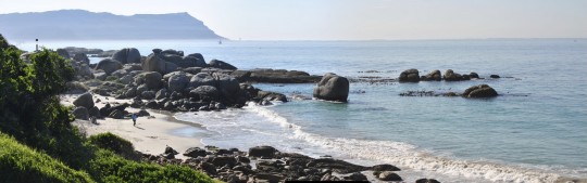
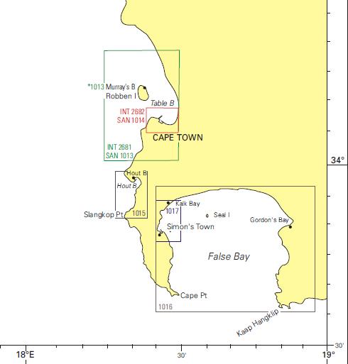
Tony has been eyeing the pipeline just south of the Lower North Battery (that collection of navy buildings with gun turrets on the Main Road just before you get into Simon’s Town) for some time. It’s north of Long Beach and further north than the wreck of the Brunswick. Even though I was coming down with what turned out to be a vicious bout of flu, I was determined to get in the water (I reckoned I was getting sick anyway…) so we went exploring one Sunday morning in midwinter.

We parked the cars on the southern side of the North Battery – there’s a little driveway and we pulled them out of the way onto the grass (here it is on Google Maps). There’s also space for just one car, pulled right off the road, right above the entry point. From there it’s a bit of a walk along the pavement, down a slope, over the railway line and then down to where the pipeline starts. You can see the single-car space next to the piece of fence, and below it the start of the pipeline to the left of the rocky outcrop in this image from Google Maps.

The entry isn’t too bad. There’s a barnacle-encrusted concrete promontory that we sat on to put our fins on, and then (theoretically) dropped forwards into the water, which was just over waist deep. While putting on my fins I got washed over backwards onto the wrong side of the promontory (thank you for my thick wetsuit!) but that turned out to be fine, as it was sheltered, and eventually I managed to get clear of the swell and kelp with a little bit of effort.

North Battery Pipeline entry point

We followed the pipeline straight out to sea. It’s not very long, but quite undisturbed, with lots of abalone and rock lobsters. There are one or two leaks in the pipeline, emitting a brownish liquid whose origins we preferred not to speculate on… it looked warm, or oily, because it shimmered a bit before mixing with the surrounding water. Tony thought it might be mountain water (tannins causing the brown colour). Hope so. Right at the end of the pipeline the visibility got really poor from all the stuff flowing out, so we turned south.

It’s all sand south of the pipeline, with lots of beautiful anemones and countless sluggish puffer fish buried in the sand. We turned after a hundred metres or so, and swam back closer in to shore. There we found what looks like the remains of a ship – four or five big rusty bits of iron sticking out of the sand in relatively shallow water. I don’t think it’s part of the Brunswick – I think we were too far north – but it could be.

Verdict: Glad we checked it out. Lots to see on the pipeline (good for macro photography) but be careful about the poor visibility at places. Curious about the bits of ship (I assume) inshore, south of the pipeline.

Dive date: 18 July 2010

Air temperature: 17 degrees

Water temperature: 12 degrees

Maximum depth: 6.5 metres

Visibility: 5 metres

Dive duration: 30 minutes

Entry techniques

It is common for similar dive sites to have a completely different entry styles, and shore diving is no different.

Boat diving will in most instances involve either a backward roll or a giant stride depending on the size of the boat and the bottom contours. A giant stride off a jetty onto a submerged object is no fun.

Giant stride
Preparing to do a giant stride off the boat in Aqaba, Jordan
Giant stride
Doing a giant stride - note the inflated BCD, and hand over regulator and mask to hold them in place.

A giant stride can be a long drop to the water on a large boat that does not have a dive platform and it is important to ensure the area is clear before you leap.

Giant stride
Hitting the water, still holding mask and regulator in place

Doing a backward roll off an inflatable has its hazards. Ensure everyone rolls at the same time to avoid landing on the person next to you. Even the slightest hesitation can result in the boat drifting slightly and you landing on a diver. Ensure that your BCD is inflated, and that you have your hand over your regulator with your fingers on your mask to hold them in place. If someone does land on you, don’t panic – just relax, remember to breathe, and wait to pop to the surface.

Underwater below the boat
It can get crowded around the boat, which is why it's important to roll off exactly when the skipper tells you to

Shore entries may have you walking through the surf to get some depth and even a small wave can knock you off your feet. Clambering over rocks at some dive sites will find you slipping and sliding about so watch the waves and time your entry and exits.

If you aren’t already wearing your mask, make sure it’s around your neck or with the strap pushed well up over your forearm, NOT on top of your head or inside a fin! Or preferably on your face already. Ensure you have your fins clipped correctly and slide the straps up over your forearm so that if you stumble and place your hands instinctively in front of you they shouldn’t get lost. As soon as you are waist deep don your fins and swim away from the shore.

Irrespective of the style of entry, before committing to enter the water ensure your gear is clipped, weight belt tight,  zipped up suits and gloves are on. Ensure your mask is on and secure and your regulator firmly in your mouth, This will ensure that should you be toppled over by a wave you will be able to see and breathe. Likewise when doing a giant stride or backward roll, place one hand on your weight belt, the other over your face with the palm holding your regulator in and the fingers holding your mask firmly on your face.

Exploring: Fisherman’s Beach

We’ve driven past Fisherman’s Beach countless times on our way to stalk the baboons at Miller’s Point, and it’s been on the to do list to dive for a while. We’d heard that it was an easy dive akin to Long Beach, and a good training venue. Also, the little wave breaking on the bright white sand makes it look almost tropical – very inviting.

We ended up diving it the same day as we checked out Sunny Cove. It’s very pretty, with low rocky reefs on either side of the beach, and a wide strip of sand across the middle. There’s lots to explore, and it certainly isn’t as busy as Long Beach. It’s a short hop down the coast to A Frame, and the marine life is thus very similar. There’s a little bit of kelp, but it’s not dense and because of the layout of the site one tends to swim around rather than through it.

Tony’s camera misted up a bit in the warm car between dives, so he didn’t take many photos, but the invertebrate life poses very nicely and there is a lot of colour and light owing to the shallowness of the site.

Fisherman’s Beach is quite exposed, far more so than Long Beach, and we’ve seen that the wave on the beach can get angry in a big swell. Also, there’s a lot of fine sand in between the rocks, and I’d imagine this can get stirred up and decrease visibility quite a lot in inclement conditions. Even some of my careless fin kicks enveloped me in a cloud of particles – so this is perhaps a good place to take more advanced students (for dives three and four of an Open Water Course, for example).

There is parking across the road, and space to kit up on the pavement or on the grass above the beach. There is an easy staircase down to the sand, and although there is more wave activity than Long Beach most of the time, it’s not as intimidating as the Clan Stuart can be.

Fisherman's Beach
Fisherman’s Beach – walk down the beach and into the sea

Verdict: Potentially a good training site, well suited for macro photography, and an easy equipment testing location for when Long Beach is too busy or too familiar.

Dive date: 4 July 2010

Air temperature: 24 degrees

Water temperature: 13 degrees

Maximum depth: 8 metres

Visibility: 12 metres

Dive duration: 37 minutes

Exploring: Sunny Cove

Tony has been wanting to dive Sunny Cove practically since he first set foot in Cape Town, having read in an old book on South African dive spots (The Dive Sites of South Africa – Anton Koornhof) that seahorses had been found there in the sea grass. Tony loves seahorses.

I put my foot down, repeatedly, until it was the dead of winter and the Sharkspotters website told me that not a single great white had been seen patrolling the coast for a couple of months. Sunny Cove is at the end of Jagger Walk, the catwalk that runs along the western edge of Fish Hoek Bay. It’s the site of at least one fatal munching by a great white, and I didn’t want to take any chances.

Sunny Cove railway station
View from the bridge over the railway line towards the dive site

It’s a shore entry, and we parked on the road at the bottom of the steps over the railway line. It’s quite a strenuous walk over the bridge with all your kit on. We spent a while figuring out where to get in – you have to clamber over some rocks, and make your way through dense kelp before getting to a clear spot. Once we decided where to get in, we were glad to be wearing thick wetsuits, otherwise we would have been scraped and scratched quite liberally! There is a huge submerged concrete block just where we got in – at first I tried to swim over it, but realised it was in only a few centimetres of water, and made my way around it. (Fortunately there was no one on the shore with a camera!) Cape Town shore diving is hard on your kit.

Sunny Cove
Our entry point is on the far left, almost out of the photo, where the straight piece of rock sticks out.

The actual dive site is aptly named. The sun streams in through the kelp, and the sea floor looks a lot like Shark Alley near Pyramid Rock – lots and lots of urchins, with pink-encrusted rock formations. We saw a little bit of sea grass, and spent a lot of time examining it for signs of life, but didn’t even find a pipe fish, let alone seahorses! There’s a lot of invertebrate life on the rocks – feather stars, brittle stars, abalone – and we saw quite a few fish.

We did see the deep channel that the sharks probably use to get in and out of Fish Hoek Bay. We were hoping to spot the beacon that records movements by tagged sharks past Sunny Cove, but no luck there. We did not explore much to the south of our entry point – that’s on the to do list (along with more sea horse hunting) for another shark-free day.

Verdict: Shallow, easy dive but a fairly tricky entry and exit. Infrequently dived, so rather more lush and unspoiled than busier sites. Videos of our dive are here and here.

[youtube=http://www.youtube.com/watch?v=DaxvdFG4Fdg&w=540]

Dive date: 4 July 2010

Air temperature: 21 degrees

Water temperature: 13 degrees

Maximum depth: 10 metres

Visibility: 6 metres

Dive duration: 32 minutes

False Bay and Cape Peninsula dive sites

Peter Southwood has a list of the dive sites in the Cape Peninsula and False Bay on his wikivoyage site for diving in the region. Here’s our list (which is just his, alphabetised, plus some other sites we’ve explored of our own accord) with links to the dive sites we’ve done specific posts on.

This post will be regularly updated as we dive new sites.

13th Apostle
A-Frame (Oatlands Point)
Albatross Rock
Alpha Reef (Outer Spaniard)
Ammunition Barges
Andre se gat
Ankers
Antipolis
Bakoven Rock
Balcony
Bantry Bay
Batsata Rock
Bikini Beach
Blouklip (Bloukrans)
Blousteen Ridge
Blue Rock Quarry
Boat Rock (Bakoven Rock)
Bordjiesrif
Brunswick
Buffels Bay
Caravan Reef
Castle Rocks and Parson’s Nose
Castor Rock
Cement Barge
Clifton Rocks
Container Bay (Mike’s Bay)
Coral Gardens (Oudekraal)
Coral Gardens (Rooiels)
Cow and Calf
Dale Brook
D-Frame (Oatlands Reef, Wave Rock)
Di’s Cracks
Die Josie
Die Perd
Dreadlocks Reef
Fan Reef
Finlay’s Point (Jenga Reef)
Finlay’s Deep
Fish Hoek Reef
Fisherman’s Beach
Froggy Pond
Geldkis
Geldkis Blinder
Hakka Reef (Middelmas)
Hangklip Ridge
Het Huis te Kraaiestein
Hout Bay Harbour
HNMS Bato
Insanity Reef
Justin’s Caves
Kalk Bay Harbour Wall
Kanobi’s Wall
Klein Pannekoek
Klein Tafelberg Reef (Salad bowl, Yacht wreck))
Kruis (Crosses)
Ledges
Logies Bay
Long Beach
Lorry Bay
Maidstone Rock
MFV Orotava
MFV Princess Elizabeth
Mike’s Point
Miller’s Point
Muizenberg Trawlers
Murray’s Bay Harbour (Robben Island)
Mushroom Pinnacle
MV Aster
MV BOS 400
MV Daeyang Family
MV Gemsbok
MV Katsu Maru
MV Rockeater
MV Romelia
MV Treasure
Noah’s Ark and the Ark Rock Wrecks

North Battery Pipeline
North Lion’s Paw
Outer Castle (Blindevals)
Outer Photographer’s Reef
P87
Partridge Point and Seal Rock
Penguin Point (Boulders)
Percy’s Hole
Phil’s Bay
Phoenix Shoal
Photographer’s Reef (JJM Reef)
Pie Rock
Pinnacle
Pringle Bay
Pringle Bay Point
Pyramid
Quarry
Rambler Rock
RMS Athens
Rocklands Blinder (Seal Colony)
Rocky Bank
Rocky Bay
Roman Rock
Roman’s Rest
Rooi-els Point
Sandy Cove
SAS Bloemfontein
SAS Fleur
SAS Gelderland
SAS Good Hope
SAS Pietermaritzburg
SAS Transvaal
SATS General Botha
Seal Island
Seal Island (Duiker island)
Sea Point Ridge Pinnacles
Sentinel
Shark Alley
Simon’s Town Harbour
Smits Cliff (Hell’s Gate)
Smits Reef (Birthday Reef, Horseshoe Reef, Batsata Maze)
Smits swim
South Lion’s Paw
South-west Reefs
Spaniard Rock
SS Bia
SS Cape Matapan
SS Clan Monroe
SS Clan Stuart
SS Hypatia
SS Lusitania
SS Maori
SS Oakburn
SS SA Seafarer
SS Star of Africa
SS Thomas T Tucker
SS Umhlali
Star Wall
Steenbras Deep Reef
Steps
Stern Reef
Stonehenge
Strawberry Rocks
Sunny Cove
Tafelberg Deep
Tafelberg Reef
Three Anchor Bay
Tivoli Pinnacles
Tony’s Reef
Torch Reef
Troglodyte’s Cove (Cave Gully)
Two Oceans Aquarium
Vogelsteen
Vulcan Rock
Whale Rock
Whirlpool cove
Whittle Rock
Windmill Beach
Wonder Reef