After foraging on the sea shore for edible seaweeds and mussels under the guidance of Roushanna and Gael from Good Hope Gardens, we returned to Gael’s house in Scarborough to prepare a meal with our finds. The group divided into four, and we worked together to prepare the food using recipes provided by Roushanna.
Decorating the sushi rolls
Sushi rice mixed with finely chopped sea lettuce (Ulva spp) formed the base of vegetarian sushi rolls, which were decorated with kelp, tongue weed, radishes, avocado, mayonnaise, and a secret sauce (recipe for the rolls here). Sea lettuce was also the seaweed of choice for a couscous and rocket salad, decorated with hibiscus flowers and miniature tomatoes (recipe for the salad here).
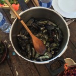
I worked on the coleslaw, made from finely sliced red cabbage, carrots, and hanging wrack (Brassicophycus brassicaeformis) – a seaweed I found so tasty and crunchy I could have sat right there in a rock pool and eaten it directly off the rocks. The mussels were picked over, scrubbed, and prepared with white wine, cream, onion, and garlic. Crusty ciabatta soaked up the sauce. Once we were done, it looked as though we had enough mussel shells for our own personal shell midden!
Rinsing and scrubbing the mussels
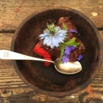
Roushanna prepared nori (purple laver, Porphyra capensis) crips for us (like kale chips, but with a crispier texture and more flavour), and chocolate nori ice cream for dessert. We supplied our own drinks. During breaks in the lunch preparation some of the group enjoyed a face (and hand) mask made from seaweed ingredients. Others of Roushanna’s recipes you can explore for yourself are for sea biscuits (scones made with sea lettuce), fruity vegan jelly, and kelp and avo salad.
Couscous salad with sea lettuce and rocket
Vegetarian sushi with sea lettuce and kelp
Coleslaw with sea wrack
Nori crisps
Mussels with white wine and garlic
Chocolate nori ice cream with edible flowers
Lunch was a collaboration, and a tasty culinary adventure. I found it marvelous to discover what is available on the sea shore, and to get a small hint of how our strandloper ancestors foraged on the Cape Peninsula.
Preparing our foraged lunch
(Puzzled what this is all about? Read my first post about coastal foraging here.)
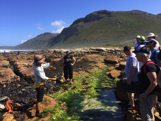
A chance conversation with a friend who also volunteers at the Two Oceans Aquarium led to me enrolling in a coastal foraging course with Roushanna and Gael Gray from Good Hope Gardens, the nursery between Scarborough and Cape Point. Their coastal foraging courses are run during the summer months (I went in December), on dates close to spring tide, so that the maximum possible area of shoreline is available to forage on. The course takes the form of a rock pool expedition on Scarborough beach, followed by lunch – prepared by the participants – at Gael’s beach cottage.
Foraging for edible seaweed
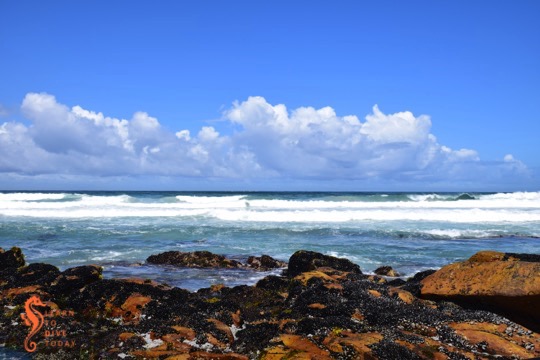
Clouds at Scarborough
Scarborough beach
Seaweed covered rocks at Scarborough
As I get older I am finding it increasingly difficult to suppress a wildly eccentric streak that frequently finds me – consciously or unconsciously – making small preparations for some kind of apocalypse (zombie or otherwise). This might be related to living on the South African roller coaster for too long, but whatever the origin of this latent anxiety, it has served to make our home life more sustainable and – little bit by little bit – more independent of the electricity grid, the municipal water system, and grocery stores. The idea of coastal foraging dovetails nicely with my desire to learn how to live a little bit more off the land than off the shelves at Woolworths!
Mollusk permit inspection by fisheries officials
It is important to respect some simple rules to ensure that your foraging is sustainable, safe, kind to the environment, and legal. Each of us had purchased a mollusk permit allowing us to harvest mussels, obtainable from the post office (available for R94 using the same form as the scuba diving in marine protected areas permit), and these were inspected by fisheries officials quite early on in our forage. You don’t need a permit to harvest seaweed (however if you wanted to do it on an industrial scale you might need to go through official channels).
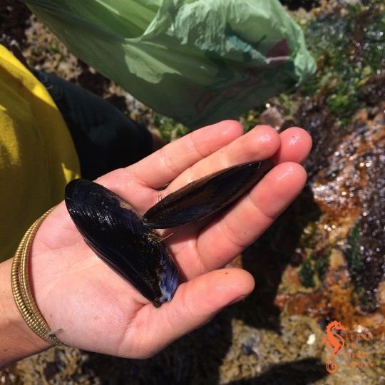
There are three types of mussels found on South Africa shores: the ribbed mussel and black mussel are indigenous, and the Mediterranean mussel is introduced. Unfortunately Mediterranean mussels out-compete the indigenous varieties, and we only saw one or two black mussels while we were out. The mussels we harvested were the Mediterranean variety, distinguishable from black mussels by the thick, flat edge to their shells. Black mussels have pointy edges all around their shells, making them more streamlined.
Mediterranean mussel (left) and black mussel (right)
There is only one type of seaweed growing along our coast that is harmful to eat (acid weed – Desmarestia firma, which has sulphuric acid in its fronds). This brown algae species does not grow on the rocky shore but only further out in the surf zone. This gives rise to the simple rule of only harvesting seaweed that is growing on the rocks, and never collecting seaweed that is floating free.
Purple laver (Porphyra capensis) on the rocks in the foreground
Sea lettuce (genus Ulva)
Hanging wrack: (Brassicophycus brassicaeformis)
When harvesting seaweed, we used a pair of scissors to avoid pulling the entire plant off the rocks, and cut no more than a third of the leaves. Seaweed is full of vitamins and minerals, particularly iodine and potassium. It isn’t something you’d make a whole meal of, but it is a healthful addition to many dishes and – once you know how to prepare it – tastes pretty good!
Clouds at Scarborough
You can read more about the Good Hope Gardens coastal foraging experience here and here. Watch this space for more about what we prepared with our seaweed spoils…
Colour front seen from Sunny Cove on 27 November 2015
Perhaps you have wondered what causes the patterns of strange coloured water in False Bay during the summer months. Perhaps you have dived in it, and wondered why sometimes you can’t see your hand in front of your face! Wonder no more – I am here to help.
Colour fronts
Frequent visitors to and residents of the shores of False Bay will observe that at certain times of the year, the ocean is marked by bands and arcs of sharply contrasting coloured water. This phenomenon is known as a colour front. In oceanography, a front is the interface or boundary between two separate masses of water. In this case, the water masses are easy to discern, because they are of different colours. There are usually other characteristics of the water on each side of the front that differ, too. Fronts are either convergent (the water masses are moving towards each other) or divergent. The presence of marine debris (like pieces of kelp) at the front boundary suggests that it is convergent.
Causes of colour fronts in False Bay
Prior to 2005, there was much conjecture about the causes of these fronts (including the usual pollution bugbear), but little evidence to support any of the theories. By sampling, the fronts were found not to be caused by pollution, or by plankton blooms in the surf zone. It was known that a colour front was most likely to occur in False Bay after a period of southerly or south easterly wind lasting a few days. October and November seem to be prime months for the phenomenon.
When a large, obvious colour front arose near Simon’s Town in November 2005 with milky green water on one side, and darker blue-green water on the other, researchers from UCT and IMT sprang into action, sampling the water on each side of the boundary so that they could measure its characteristics. Speed is of the essence in these situations; colour fronts can disappear quickly. The one in the picture below is busy decaying – notice the smudged boundary.
Colour front in north western False Bay on 13 November 2014
Measurements revealed that the milky green water overlaid the clearer, bluer water, down to a depth of 11-12 metres (this will vary from front to front). The milky water did not extend to the ocean floor. Scuba divers around the Cape Peninsula will be familiar with the experience of diving through two or more layers of water, with varying turbidity (clarity) and temperature! (Here is picture of Tony and Christo diving near Oudekraal in the Atlantic that shows what the boundary between two layers of water can look like.)
The researchers found that the milky coloured greenish water was full of fine, almost neutrally buoyant particles of calcium-rich sediment. The green-blue water contained much less calcium, but relatively more silicon, which would suggest the presence of diatoms (a kind of phytoplankton – you can think of them as teeny tiny plant-like organisms) or sand in the water. The origins of the calcium-enriched sediment in the milky water are interesting: one source is from the shallows (less than 30 metres deep) of north western corner of False Bay, where the ocean floor is made up of rocks that are rich in calcium carbonate (such calcrete and limestone), some areas covered by a thin layer of sand.
Milky-white water near Swartklip on 29 November 2014
The second probable origin for the particles of calcium-rich material is the interface between the sea and the land at the northern end of False Bay. The cliffs at Wolfgat/Swartklip at the head of the bay are made of calcrete, and at Swartklip the beach narrows to the extent that the cliffs erode directly into the water when the sea is high. Strong southerly winds create a wide (of the order of one kilometre) surf zone at Muizenberg and Strandfontein; a spring tide also adds to ideal conditions for the generation of a colour front.
The temperature of the milky water was found to be slightly (0.4 degrees Celcius) higher than the green-blue water. This measurement will also vary from front to front. The researchers speculate that the temperature difference could be because the milky water originated in the surf zone, which is shallower and therefore warmer, or because the high concentration of suspended particles in the milky water caused greater absorption of heat from the sun.
Colour front at Smitswinkel Bay on 24 October 2014
Summary
Here’s the tl;dr: strong southerly and/or south easterly winds, perhaps coupled with spring tide conditions, set up a very wide surf zone along the northern end of False Bay, which disturbs the sediment on the ocean bottom and drives the waves further up the beach than usual. Particles of buoyant calcium carbonate from the sea floor and eroded from the cliffs at Swartklip are lifted up into the water column, changing its colour to a milky-green shade. Wind-driven circulation patterns in the bay push the front from its original location in a southerly direction, towards Simon’s Town.
What to do?
Contrary to what your friends on social media may claim, not all colour changes in the ocean around Cape Town can be attributed to a giant sewerage plume. Hardly any of them can, in fact. In summer, the reason for the ocean looking green, red or even brown is likely to do with a plankton bloom of some description, or related to suspended sediments (as in this case) or other naturally arising material in the water. Instead of using this as an opportunity to become hysterical on the internet, how about celebrating the incredibly dynamic system that we can observe, living near the ocean? Drive up a mountain next to the ocean and take in the spectacle from on high. Dip your face in the water and see what it does to the viz. Take some pictures for posterity. And – if you don’t know what’s causing it – try to find and question someone who does know, like a scientist, or consult a good non-fiction book, to find out some facts.
One day in October last year (there are no acceptable excuses for the delay posting this, so we’ll just leave it at that), Seahorse and her skipper were chartered by a multi-disciplinary team who are working on a project called Sea-Change. If you’ve visited the Sea Point promenade recently, you might have seen a beautiful array of mini-billboards featuring photographs of sevengill cowsharks, kelp forests, and other marine life, including recreations of how early humans may have interacted with the marine environment in the Cape.
Misty morning
The Sea-Change team wanted to find a co-operative whale to swim with and film, being in possession of the necessary permits (many pages of paperwork). It was late in the season for whales in False Bay, and we spent a morning looking for them without any luck. Reports of whales on the Atlantic seaboard led us to Hout Bay about a week later.
Leaping seals
It was a misty day, and we went as far north as Clifton without seeing any whales. We did see a large sunfish and lots of seabirds (including rows of terns perching on pieces of kelp), and we spent some time at the seal colony at Duiker Island, where the team spent over an hour in the water… without wetsuits! Just as we were about to call it a day we spotted a whale at the entrance to Hout Bay – it may have been there the whole time but the mist was too thick for it to be seen. Unfortunately it didn’t want its picture taken, so we had to call off the search for another day.
An observant visitor to the promenade between Mouille Point and Green Point may notice something man-made sticking out of the ocean, less than 100 metres from shore. This artifact is the iron engine block of the Royal Mail Steamer Athens, which ran aground here in the great north westerly gale of 17 May 1865. Seventeen ships were wrecked during this colossal gale – reports of the events of that day (including a mention of the Athens) can be seen in this historical newspaper.
The engine block of RMS Athens is barely visible to the left of this image
It is possible to dive the wreck; indeed, owing to its accessibility from shore, it has been extensively “salvaged” in the last 150-plus years! There is more information about diving the wreck on wikivoyage, but suffice it to say it’s a shallow dive best done when there is no swell to speak of. The wreck is very broken up and overgrown with kelp and invertebrate life, by all accounts.
What remains of RMS Athens
The stretch of shore where RMS Athens came to grief
RMS Athens seen from the sea
There’s a great article on the history of RMS Athens on the Submerge website: click here to read it.
If you want to go and see the remains of the wreck, I’ve geotagged this instagram picture of the engine block. My photos of the engine block as seen from the sea were taken while we were aboard the Ocean Adventurer. If you’re interested in other visible shipwrecks around Cape Town, you could visit the Kakapo, the Clan Stuart, and (by boat) the BOS 400, to start with!
Our wedding starfish at Long Beach… see, he is lying in a heart shape!
The starfish in this picture may or may not still be alive (my guess is not), but it looks very much like a starfish in the early stages of Sea Star Wasting Syndrome (SSWS), minus a few legs. (It isn’t sick – I photographed it at Long Beach a few years ago – and it is actually an invasive species on South Africa’s coast.) Sea stars on the Pacific coast of North America began sickening – suppurating and disintegrating – in mid-2013, and scientists have been scrambling to find the cause. Initially it was not clear what was causing the sea stars to die in such grisly ways: pollution, warming oceans, large storms and other possibilities were considered. The clue that told scientists that the cause was “microscopic and biological” (in the words of National Geographic Phenomena blogger Ed Yong, who covers the subject with admirable clarity) was that starfish in aquaria, who were bathed in water pumped from the ocean and filtered, were also dying.
Yong’s post explains how scientists isolated the virus (a process involving blending, filtering, and genetic sequencing), and what scientists are hoping to learn from the work they have done on this subject. Potential parallels between SSWS and viruses that periodically flare up in human populations (Ebola being a recent example) are interesting.
At The Verge, Elizabeth Lopatto writes in more detail about SSWS, its discovery, and consequences. She points out that sea stars are a “keystone species”, and that
Keystone species help maintain an ecosystem by eating quickly-reproducing prey species like urchins and mussels — keeping populations low. Without the sea stars, the urchin population explodes; bad news for the kelp forests and everything in them. Giant kelp can grow to 150 feet underwater at a speed of two feet a day, but their weaknesses are their holdfasts, which are sort of like tree roots. The holdfasts are home to brittle stars, prawns and snails, among other creatures. Urchins like to eat the kelp holdfasts. Without them, the rest of the kelp drifts off in the tides. In this way, urchins can devour forests, which, higher up, are also home to fish, including several types of commercially-important rockfish, according to the National Oceanic and Atmospheric Administration.
Yesterday, 21 November 2014, marked 100 years since the SS Clan Stuart, a British turret steamer of 3 594 tons, ran aground in a south easterly gale off Glencairn at two o’clock in the morning. She was on her way from St Helena island with a cargo of coal, and dragged her anchor in the gale. Fittingly, the anniversary of her foundering was also marked by a strong south easterly wind!
The entire crew was rescued, but returned to the ship during efforts to refloat her. She was pumped out and pulled off the rocks by a tug from Table Bay, but permission for her to enter the dry dock at Simon’s Town was refused for fear that she sink and block the entrance to the harbour. Her captain was thus compelled to run her aground at Mackerel Bay, where she now lies, in order to prevent her from sinking.
The Clan Stuart today
She is now a well known landmark to drivers on their way along the coastal road between Simon’s Town and Glencairn, as well as being a popular shore dive site. We’ve had some great dives there, and here’s a round up of some of the material we’ve published about the wreck since starting this blog:
The wreck is quite heavily encrusted and there’s usually a lot to see. We’ve seen cuttlefish, small schools of two tone fingerfin, and for some reason I always see a wide variety of worms there! There is kelp growing on and around the wreck, but not so much that it’s hard to move around. On the beach we sometimes see African oystercatchers with their striking red legs and bills, and black bodies. Cormorants and gulls often perch on top of the engine block, too, giving them a convenient platform from which to go fishing.
On our first night dive together (Tony’s first in Cape Town, and my first night dive ever) Tony took a video (grainy) of some seals that joned us on the dive – you can find it in our post about Cape fur seals.
We also spotted a onefin electric ray on a dive on the wreck, whose electric personality seemed to interfere interestingly with Tony’s video camera.
On one memorable dive on the Clan Stuart (I think it was on 1 January one year, in the height of summer), we were surrounded by an agitated school of large white steenbras, who seemed to be trying to take cover behind us and on the wreck, repeatedly changing direction and swirling around us. Tony and I concluded independently that something large and toothy was chasing them, and exited the water by practically tunneling our way to the beach, trying to appear relaxed for the sake of the students accompanying us.
A few years later a group of Russian divers accompanied by two locals – diving off the boat this time – actually came face to face with a great white shark on the Clan Stuart – here is Tony’s story, Christo’s story, Craig’s story, and a short video of the shark taken by one of the Russian visitors. Undaunted by their experience they ended the dive on the beach, where I picked them up, drove them back to the jetty to get back on the boat, and they set out for another dive!
Diving the Clan Stuart
The best time to dive the wreck, in light of the above information and the typical movements of sharks in False Bay’s waters, is in winter. The visibility is likely to be better then, though it’s rarely exceptional (I would be ecstatic with 10 metres, and expect closer to six in the winter months). In summer you can expect 2-5 metre visibility. Don’t underestimate the waves on the beach, and keep your regulator in your mouth until you’re through. Save the chit chat for when you’re back on dry land!
Find out more
A team of film makers has been working on a project about the Clan Stuart for some time. Here’s some of their work so far:
We took the drone down to Glencairn Beach one evening so that I could stroll and enjoy the sunset, and Tony could fly a bit. The SA Agulhas (now a SAMSA training vessel) was in False Bay, seen near Roman Rock lighthouse. Tony hoped absently that it had run aground, thus supplying us with a new wreck to dive.
Roman Rock & SA Agulhas in the distance
There had been a bit of winter rain, so the Else River was in full flood. The waves on the beach were small and quiet. The sand seemed impossibly smooth and glossy. The colours of the sea and sky melted into one another near the horizon. It was one of those evenings that calms you down, regardless of how the day has been.
Tony flying the drone
Kelp on the beach at sunset
View from Glencairn to Simon’s Town
Looking north from Glencairn beach
Placid sunset scene at Glencairn
Tony getting the drone ready
Here’s a little bit of Tony’s video from the evening:
I had high hopes for The Death and Life of Monterey Bay, for reasons that will be revealed (I hope) in the course of the next few years. Monterey Bay is in California, and opens onto the Pacific Ocean. It has approximately the same surface area as False Bay but is shallower and less square. Filled with diverse marine life, it was formerly bounded by a row of sardine canneries (setting for John Steinbeck’s novel Cannery Row) which were responsible for massive pollution in the area. Tons of stinking sardine guts fouled up the bay, which had been stripped of much of its marine life by aggressive fishing practices and cascading effects in the ecosystem.
In 1892 the Hopkins Marine Station was founded, a research laboratory of Stanford University. In 1931, the area of ocean in front of the lab was designated the Hopkins Marine Life Refuge (now Reserve). The bay’s populations of abalone, sea otters, killer whales, kelp forests, whales, and other life gradually recovered, and the sea urchin barrens were overgrown and once again supported a variety of life.
In this book Palumbi and Sotka trace the decline and recovery of the bay, lingering on colourful local characters such as Monterey mayor Julia Platt, whose no-nonsense attitude ensured access to the ocean for all the residents of the area. I expected the book to be more about marine biology, with information about how the various species recovered in the ecosystem once the polluting and overfishing forces were removed, but it is definitely more of a human history, with a strong focus on Platt, John Steinbeck, and his friend Ed Ricketts, with whom he travelled to the Sea of Cortez.
The establishment of the Monterey Bay Aquarium on Cannery Row effectively redeemed an area that was the source of seemingly limitless pollution. The aquarium was opened in 1984 after years of planning. It is a sister aquarium to Cape Town’s Two Oceans Aquarium, and also has the distinction of being the first aquarium to attempt to exhibit a (juvenile) great white shark, an enterprise that (fortunately) seems doomed to failure.
There’s an excellent article on Palumbi and the book here.
Here’s Stephen Palumbi giving a TEDx talk on how Monterey Bay came back to life: