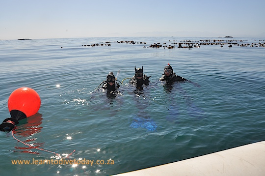
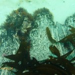
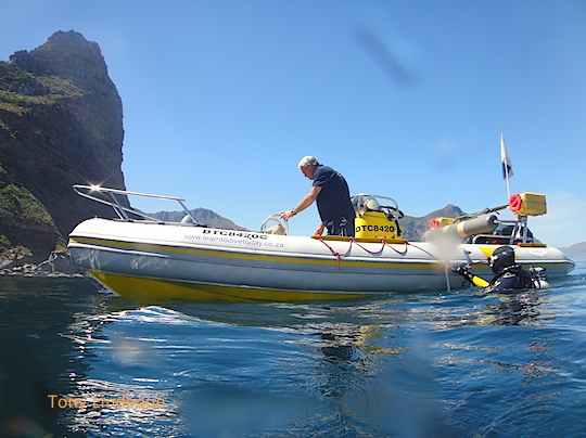
We spent a really great day in on and under the water working on a film shoot today without traveling more than 100 metres from Millers Point. The water was clean, the sun was out and about and the wind not too hectic. I could use about 6 such days a week, thanks.
Seahorse at the Miller’s Point jetty
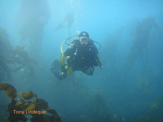
There hasn’t been a lot of diving otherwise this week, and the weatherman has been getting it wrong quite regularly, much to my annoyance. We did dive students last weekend, and while we were navigating the boiling pea soup at Shark Alley (no cowsharks at the moment – they’re on their annual hiatus) a radio controlled plane with a wingspan of about three metres crashed into the kelp near the boat. Brian did some heroic swimming, towed the plane to the boat, and we loaded it on board and delivered it to its owner at the Miller’s Point slipway. There were some tense moments when the electronics started smoking while it was on the boat!
Brian passes his swim test with flying colours
Weekend dives
Deciding on whether or not to dive on weekends has been a little difficult of late as the forecasts are so often way off the mark. It’s almost a requirement to go out and take a look every evening and early every morning. Yesterday the Atlantic – well, Hout Bay – looked appalling and False Bay looked marginal. Today it’s a different story and False Bay was clean.
Never mind, this weekend we have swell, wind, perhaps rain and maybe even sun. Tomorrow early looks good, and Saturday will be OK but really surgy, Sunday will be howling… If the forecast is right. I have students, tourists and local divers so I will dive somewhere at some point if the weather looks good enough… Totally confused? Good, so am I. If you want to try for a dive, let me know and I’ll notify you if and when we hit the water.
21 September is International Coastal Cleanup day, and we will be joining OMSAC and FBUC at False Bay Yacht Club, a venue with which those of you who’ve boat dived with me will be well familiar. The event details are here; if you plan to come along, you must sign up as instructed. There may be a registration fee to participate. It’s a lot of fun – we’ve cleaned at Robben Island and Hout Bay Harbour in the past – and a very good cause to get involved in. Encourage your non-diving friends to join a local beach cleanup.
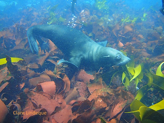
The photograph above was taken by Dave Hurwitz of Simon’s Town Boat Company, the holder of the whale watching licence for False Bay. I noticed the whale watching boat coming closer and closer as I was taking a group of divers out of the water at Seal Rock, and it was only once they were in the boat that we realised that a pair of humpback whales was coming closer and closer to our position. We held our breath and enjoyed the show – it is not often that this happens!
At this time of year there are both humpback and southern right whales in the bay, but there are strict regulations about approaching them. In this case the whale approached us, and I wasn’t about to leave the divers on the surface while I was busy retrieving them!
Humpback whales
Diving humpback whale
Flukes in the air
Disappearing act
This amazing experience was only one of the parts of this day, which started early and ended late after two separate charters. One was a group of Finnish tourists who snorkeled and dived with the seals at Partridge Point – they were the ones lucky enough to enjoy the spectacle of the whales.
Snorkelers on the boat
Seal Rock at Partridge Point
Sleepy seals
Massive bull seal at Partridge Point
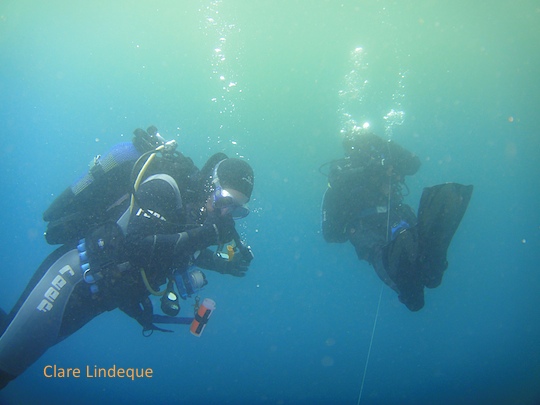
The second charter was a group of divers who wanted to dive with the seals, and then visit the cowsharks at Shark Alley. The visibility was so good I could see the divers on the bottom. We spotted an absolutely enormous bull seal on the rocks at Seal Rock, as well as some really adorable smaller juvenile seals.
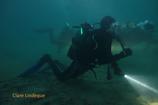
The second clip, which was taken just a minute or two later, is much darker – the sun was setting at that very moment. At the end you can see Tony in his Batman hoodie. You can also glimpse Craig over the kelp on the wreck, with the buoy line, and Tamsyn in a wetsuit with blue detailing on the arms. We were eight all together for this dive, and the light shed by our torches and cyalumes is quite considerable.
For another glimpse of what night diving is like, you can check out another video here.
Tony and students on the surface over the wreck of the Brunswick
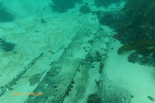
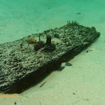
The Brunswick is a historical wooden shipwreck that lies a few hundred metres off the northern end of Long Beach in Simon’s Town, directly opposite the northern end of the white apartment buildings overlooking the Main Road. Like HNMS Bato, she is infrequently dived. Having lain underwater since 1805, she is heavily overgrown and much of her decking and hull is covered by sand. She used to be a shore entry (with a precipitous climb over the railway line), but in recent years a large number of boulders have been added as a breakwater between the ocean and the railway line, and climbing over in dive gear is no longer possible. For this reason we do the dive from the boat. Close to shore and in shallow water, the Brunswick is an ideal site to get used to boat diving.
Extensive field of wooden decking
The Brunswick was a British East Indiaman, which means she carried men and goods between Britain and the East Indies – (south)east Asia and India. She was carrying a cargo of cotton and sandalwood from China back to Britain when she was captured by some French vessels off Sri Lanka, and brought to Simon’s Bay. In September 1805 her anchor rope parted, and she ran aground during a south easterly gale. Most of her cargo was salvaged, as she lies in shallow (less than six metres deep) water.
Shot line on the sand
The boat from below
An encrusted iron knee
An iron knee in the wreckage
Planking on the Brunswick
Kelp grows on the wooden remains
Puffadder shyshark
Octopus hole
Hermit crabs swarm over the wood
Cape rock crab
Craig looking underneath
Bolt sticking out of the wreck
Tags on the wreck from a prior archaeological survey
Tags on the wreck from a prior archaeological survey
Starfish attached to a bolt
Copper bolt next to a rock lobster
Starfish and copper drift bolt
Pointy bolt
Some of the metal is worn smooth or recently uncovered
Drift bolts in the planking
Corroded iron driftbolt
Side view showing how thick the planks are
Much of the wreck lies under the sand
Another concreted metal item
Octopus surrounded by hermit crabs
Wooden remains from the Brunswick
Christo approaches the boat after the dive
We found the dive site to be similar to HNMS Bato, which was also a sturdily built wooden ship of similar vintage. The Brunswick was 1,200 tons, and her wreckage is spread out quite extensively. There are many thick, wooden planks, laid out as they would have been to form her decks, as well as much evidence of the bronze bolts that secured parts of the ship together. There are also many copper bolts, rivets and what could be small amounts of rolled up copper sheathing in evidence on the site.
Anemone among feather stars and papery burnupena
The highests parts of the wreck are covered with feather stars, anemones, sea cucumbers, and kelp. There are many octopus, and peering under the wreckage with a torch yielded a couple of very large pyjama catsharks. We were lucky to dive the site most recently on a day with lovely visibility, and the shallowness of the water means that there’s a lot of light penetration which improves things enormously.
The highest parts of the Brunswick wreck
Before diving this site, you should call the SA Navy Ops Room on 021 787 3818, to ask for permission and to tell them how long you’ll be. Same procedure as at Long Beach.
I don’t think this dive site has a name (other than what we call it), or that it’s high on anyone else’s list of fun places to dive, but it’s proved to be a reliable and quite lovely site that’s specially suitable for new divers.
The Sentinel is that striking mountain outcrop that stands at the entrance to Hout Bay, dropping off steeply into the Atlantic. Beneath it is a fairly dense kelp forest and a scattering of smallish round boulders that add variation to the underwater landscape. The maximum depth in the area is not more than about eight metres.
Kelp forest
We dived the site after a dive on the SS Maori, on a day when the visibility was not magnificent, but tolerable. Tony has on many occasions taken students there and found that the water is far cleaner than it is at Duiker Island nearby (probably less run off of seal bodily fluids…) and inside Hout Bay. The site can be a little uncomfortable when it is very surgy, as the movement of the kelp and the seaweed beneath you on the rocks is disconcerting.
Kate is neutrally buoyant
There are not many large fish – this is typical of the inshore Atlantic sites we dive – but in summer clouds of West coast rock lobster larvae and other fish fry may cause the water to shimmer hazily. I can guarantee you that you will not see a single abalone, though if you swim right up to shore in this area you will see thousands and thousands and thousands of empty abalone shells in the shallows and on the beach. This is where the poachers who rule Hout Bay shuck the perlemoen before carrying them up the mountain to dispose of them.
I’m going to go out on a limb here and say that this is the worst movie ever made. I don’t think a worse movie could be made; I’m willing to make this prediction even if the human race continues making movies in their current form until the end of civilisation. The fact that this is an appalling film shouldn’t put you off seeing it if you live in Cape Town, however. If you’re a Halle Berry fan, you will probably also be interested in this offering, and your enjoyment will probably be enhanced by viewing the film with the sound turned off. The movie was filmed a couple of years ago in Simon’s Town (False Bay Yacht Club, Bertha’s restaurant, and the jetty outside Bertha’s all feature) and False Bay. There is brief footage at (I think – it’s dark) Miller’s Point, Boulders Beach, and a fair amount shot at Seal Island. The underwater footage looked like it was shot in a kelp forest off Duiker Island in Hout Bay. Lots of seals. There was a lot of kelp – more than I remember there being at Seal Rock near Partridge Point. It could also have been shot at Seal Island (where it purports to be) in summer, but the water is quite clean which makes me unsure. There are about six characters, most of whom are played by local actors. We are treated to a variety of accents, sometimes several different ones from a single individual. There is a lot of supposedly endearing and humourous banter between Berry and her local staff members, which I just found patronising and offensive. Halle Berry’s character, Kate, freedives with white sharks. After causing the death of her safety diver (he was eaten), she retires from shark diving and takes people on boat tours to Boulders Beach to look at penguins and to Seal Island to look at seals. She can do this all in one short trip because Boulders is on the way to Seal Island when you sail out of Simon’s Town. Right? Right! (Another interesting fact I didn’t know about the geography of False Bay is that Seal Island is a 20 minute surface swim from Miller’s Point. The abalone poachers apparently do it often, but have a “less than 50% chance” of making it back.) It was fun to see Simon’s Town on film, and to identify that Kate’s office is actually the clubhouse for the kids’ dabchick sailing school at FBYC. A wealthy man of indeterminate nationality wants to swim with white sharks outside a cage. Kate is tricked (sort of) into taking him to do so. At seal island they see a couple of sharks, but the millionaire cannot follow instructions (“stay in the cage”) and Kate discovers that her boyfriend promised him a cageless dive without consulting her. After an INORDINATE amount of shouting and screaming on the boat, Kate loses her rag and decides to take the millionaire “around the point” to “Shark Alley” where the really big great white sharks can be found, to teach him a lesson. (Readers unfamiliar with Cape Town should know that there is a place here called Shark Alley, but it’s inside False Bay and no white sharks are found there… Only sevengill cowsharks.) Despite the worsening weather they make the trip, and at this point the movie becomes a cross between The Perfect Storm and Jaws. There is a lot more shouting on the boat. Lots of people get eaten by sharks. No doubt the NSRI is called. Not many of the characters make it home. To sum up, several people die in extremely violent and gory shark attacks. The blame for all of the deaths can be laid at Berry’s character Kate’s feet. She is immature, has a bad temper, and is incapable of assessing risk. Unfortunately she survives. Some of the shark footage is nice. An alternative title for the film could be “Shouting on a Boat” or “Halle Berry in Small and/or Tight Clothing”. If either of those appeal, by all means, be my guest. I hope the Department of Environmental Affairs, FBYC and STADCO made some nice money out of issuing permits and renting facilities for this film (really). It’s great that local venues are benefiting from the international film industry. SharkLife apparently sponsored a lot of the clothing worn in the film. Their logo was everywhere. I watched the credits with greater attentiveness than I did the rest of the movie, looking for familiar names among the stunt divers, skippers, cameramen and extras who featured. I found some! You can buy the DVD here if you’re in South Africa, otherwise here or here.
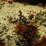
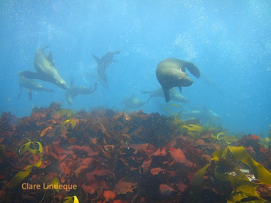
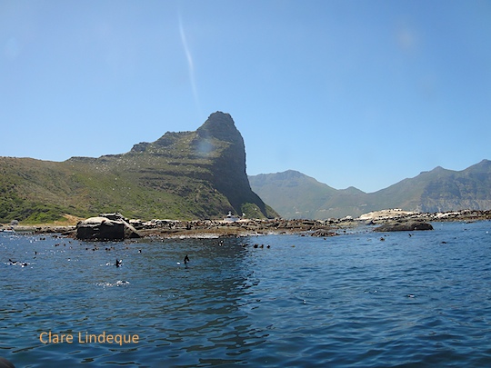
False Bay is home to two seal colonies/haul out areas: Seal Island, which is inhabited by up to 70,000 seals, and the much smaller (a couple of hundred seals at most) Partridge Point haul out area, known as Seal Rock (perhaps only by me). For very sound reasons of safety, there is no scuba diving at Seal Island, but there is lovely diving and snorkeling at Seal Rock (Partridge Point). When eastern False Bay is whipped to a murky maelstrom by the south easterly wind, which prevails in summer, there is another option for those who wish to spend time with seals in the water.
A seal watching boat next to Duiker Island
Duiker Island is located just outside Hout Bay, around the corner from the Sentinel. It’s a low rock surrounded by relatively shallow water and inhabited by a few hundred seals. The south easterly wind cleans the water on the western side of the Cape Peninsula, bringing clear, cold water from the deep sea up onto the coast. If the wind isn’t too strong and the swell is safe (avoid this area when the swell is south westerly or very westerly – it’s dangerous) this is a wonderful place to snorkel or dive with Cape fur seals. A 4 kilometre boat ride is required to get here.
Seals over the reef at Duiker Island
It’s important to stay away from the channel between Duiker Island and the mainland, as that is where the seal watching charters from Hout Bay turn around to return to the harbour. Most diving is done on the north western side of the island where it is too shallow for the charter boats to come.
The seals are curious, playful, and sometimes quite pushy. You need to be confident and not flail your arms around; it’s like being in the presence of dogs you don’t know. They will come quite close, and occasionally do dominance displays of open mouths and large teeth. Keep your hands to yourself and don’t worry. Their underwater ballet is beautiful and diving with them is a pleasure.
Part of the reef at Duiker Island
The reef here is not as interesting as the reef around the False Bay colony at Partridge Point, but it is pretty. The rocks form several shallow, natural amphitheatres of several tens of metres diameter. There’s a lot of red seaweed and kelp, which the seals play with. One seal on our recent dive there tore strips of red seaweed off the rocks and trailed them behind him, while another removed a small kelp plant from its anchor and flung it about in the water like a toy.
This seal lay down in front of Tony
Unfortunately my camera was misting up on the day we dived here, so the pictures don’t quite do the lovely visibility justice.
One of the pinnacles, rising to within 10 metres of the surface
It seems that it’s only on magnificent days that we end up launching from Oceana Power Boat Club. While my colleagues were having an end of year function just above Clifton Beach, I was floating on the surface a few hundred metres off the same beach, waiting to be picked up by the boat after a dive. You’ll recall that we had a week or more of incredibly strong southeasterly winds at the end of November. The wind dropped during the night of 30 November, and hours later we were on the boat. The aim was to complete Christo’s deep dive for his Advanced course, and our hope was for excellent visibility.
Christo & Tony at the safety stop, at the thermocline
The Atlantic is so capricious, however, that the surface layer was already turning green with a layer of happily multiplying phytoplankton when we arrived to dive it. I am unreasonably pleased with this picture of Christo and Tony at the safety stop, right at the boundary of the blue and green water.
Brittle stars and mussels
Starting the dive
Sea fan
Christo and Tony at Monty’s Pinnacles
The reef wall covered with life
Tony and Christo discussing dive time
The reef extends into the blue
Swimming through a channel between boulders
Sunburst soft coral
Tumbled granite
Spectacular topography at Monty’s Pinnacles
White boulder
Small stands of kelp at 25 metres
Granite and kelp
Comb sea jelly at the safety stop
Beneath the layer of pale green we discovered crystal clear, freezing cold water. I can well understand how falling into the water in the Southern Ocean or Bering Sea can be fatal after this dive. Towards the end I doubted my ability to swim for the surface, and just wanted to lie down on the bottom and go to sleep!
Sponge with brittle stars
Monty’s Pinnacles refers to part of the North Paw complex, a large area of granite reef that has several distinct dive sites within it. We have also dived the northern pinnacle. Monty’s Pinnacles lie a short distance to the north of the exposed rocks that mark the main North Paw reef. There’s a map here. The two pinnacles were discovered by local diving legend Monty Guest while scootering around the area in 2010. They rise to within 10 metres of the surface. The topography is spectacular, with great ridges in the granite that are so straight as to appear to be machine-hewed. Small stands of kelp grow all the way down to 25 metres, testifying to the clarity of the water here at certain times of the year.
Tony and some brittle stars on a boulder
I didn’t see much unusual macro life (perhaps in my near-hypothermic state I had reduced powers of observation), but the rocks are heavily encrusted with mussels, brittle stars, and urchins. There are very large west coast rock lobsters everywhere you look. I saw the odd sea cucumber and a couple of anemones, but the chief beauty of this site for me is the passages and tumbled boulders that one swims among. There are swim throughs here, but we didn’t find them.
Granite reef
The view upon surfacing is spectacular, with the Twelve Apostles and the Atlantic seaboard to feast your eyes on.
Straight cuts through the granite
Dive date: 1 December 2012
Air temperature: 28 degrees
Water temperature: 9 degrees
Maximum depth: 25.9 metres
Visibility: 15 metres
Dive duration: 30 minutes
Violet spotted anemonesMini pinnacle (not one of the official ones)
The Save Our Seas Shark Centre in Kalk Bay held another marine speaker series this November, and Tony and I attended a couple of the talks. One which we enjoyed was given by Alison Kock, research manager at Shark Spotters. Shark Spotters is a beach safety program that Capetonians are rightly very proud of – there’s more about it on the Shark Spotters website, here and here. Alison’s talk focused on some updates as to the research that is going on in False Bay, and extensions of the spotting program.
Updates on the shark spotting program
Between 2004 and 2012 the shark spotters have made more than 1,400 sightings of white sharks, 60% of which resulted in beach closures. The sharks are either resting, passing by, or searching for prey (other sharks, rays, fish) when they come inshore in summer. For spotting to be effective, at least 40 metres of elevation is required from which to observe the beach. The beaches in False Bay differ, in that sightings at Muizenberg resulted in a beach closure only 30% of the time, while at Fish Hoek the beach was closed 80% of the time. This is because of the nature of the surf and sharks’ behaviour at the different beaches.
At Muizenberg, the backline is some 300 metres off the beach, and the majority of the time sharks are cruising along behind the backline or further off the beach. The beach is only closed when sharks enter the surf zone – 74% of the time they are simply swimming past the beach. When a shark is behind the surf zone, the red flag is raised (for High Shark Alert) but the beach remains open.
At Fish Hoek, 61% of the sharks remain behind the breakers, but this is a mere 50-100 metres from the beach. 68% of the sharks are swimming past, but their proxmity to the beach means that more beach closures take place than at Muizenberg. The lookout location at Fish Hoek is on the mountainside, 110 metres above the beach.
Shark exclusion net at Fish Hoek
Fish Hoek is to be the site of a trial shark exclusion net that will be tested in the next month or two, all going well. It’s important to understand that this is an exclusion net, not a gill net, and the team in charge of the trial have been mandated to design and construct a net that will not lead to bycatch of any marine species. The aim is not to kill sharks and reduce the population, thus reducing the chance of interactions with people (this is what the Durban nets do), but rather to build a “wall” in the sea to keep them out of a specific area of Fish Hoek Bay in order to make it safe for swimming.
The other important thing to remember is that nothing like this has ever been done before. Owing to the strength of the wind and swells that we experience in Cape Town’s summer, and the presence of large amounts of kelp in False Bay which can foul the net, the net will only be deployed on calm days and will be removed overnight. The net has been designed and is being constructed at the moment, but the process of deploying and removing it (to be handled by the trek fishermen) will be a learning experience initially. If the initial prototype has flaws, the City of Cape Town is determined to iron them out and make it work. It would be courteous and generous of the media and other observers to recognise that this is a world first, and to allow for an initial period of change and possible disruption as the net is tested and refined.
New spotting locations
Earlier this year, Caves at Kogel Bay (on the eastern side of False Bay beyond Gordon’s Bay) was added as a spotting beach. This is a popular surfing location and the water is relatively deep as much of the coastline in that location is rocky cliffs. There have been numerous sightings there since spotting commenced, confirming that this site seems to be on a route that white sharks take in and out of False Bay.
Monwabisi Beach on the northern end of False Bay is the site of up to 10 drownings per year, owing to dangerous rip currents that are, in part, a result of artificial structures constructed for swimming (see the satellite image below). Shark Spotters is adding Monwabisi Beach to the list of regular beaches that have spotters on duty. This is an exciting development and will be particularly important if the proposed oceanfront development along Baden Powell Drive takes place.
South African researchers collaborated with scientists in Australia to test the effectiveness of SharkShield, a portable device for use by surfers and divers and intended to repel sharks with a magnetic field. The South Africa researchers towed a seal decoy at Seal Island with the SharkShield attached, while the Australians tested it in natural predation situations. They found that the device does not attract sharks (this I imagine would be the absolute minimum functionality required before one even considered using it!). The device repelled some sharks, but not all of them, and its effectiveness depended on the shark’s state of mind. The range of its effectiveness was found to be about 2 metres diameter from the object. The full research study is available here.
Safety tips
Sign at the end of Fish Hoek beach
Alison concluded her talk with some shark safety tips, of which it’s good to remind oneself of once in a while (specially in summer):
Be aware of your surroundings. The presence of dolphins, bird activity, or fishing may indicate that white sharks will be in the area. Don’t let the cute dolphins distract you and get your guard down!
Check out recent sightings. Visit the Shark Spotters facebook page, and make sure you understand the flag system and read the signs at the beaches you visit.
Don’t swim at night, in low light (sunrise and sunset), or in murky water (such as at a river mouth) or poor visibility.
Stay in shallow water. Three quarters of shark activity at our beaches is behind the backline.
Avoid high risk times and areas when you go swimming.
Stay in groups – don’t get separated or swim out far beyond the other water users.
Christo (behind water droplet) enters the water at the end of Long Beach
I have wanted to dive HNMS Bato for some time, but the 450 metre walk down Long Beach to reach the entry point for the wreck deterred me. The 450 metre walk back to the parking area enthused me even less. A full set of diving gear weighs at least 25 kilograms, assuming a 6-7 kilogram weight belt, and one isn’t particularly mobile in a wetsuit. Christo has dived this wreck a few times on his own, and one breezy Saturday, feeling strong, I joined him.
Burnt edges of the deck
Unlike the area of Long Beach along the pipeline, this is a very infrequently dived site. The Bato was a Dutch (the “N” in “HNMS” stands for “Netherlands”) warship that caught alight and sank on 8 January 1806, after being used as a floating battery. She lies in relatively shallow water – less than 5 metres deep at high tide – so we took extra weight with us to ensure that we could stay on the wreck.
A root mouth sea jelly in the shallows
Copper encrusted wreckage
Rolled up copper sheets
Cushion star
Rolled up copper
Hottentot in the kelp
Decking
Copper in amongst the wreckage
A klipfish in the kelp
Urchins take shelter on the wreck
The edge of the deck, showing its thickness
A large nail head in the wood
More copper
Close up of the rivet holes
Rivets have rusted away leaving holes in the wood
The wreck is thus over 200 years old, and was partially burned before she ran aground and sank, so you should manage your expectations accordingly. That said, large areas of decking are visible, as well as rivets, studs, and some holes in the wood where some of these have rusted away. Much of the wreck must lie under the sand, and the entire remaining structure, which is not more than a metre off the sand at its highest point, is covered with a dense layer of kelp and sea lettuce. Diving her is thus an exercise in patience: one hangs (sometimes made difficult by surge) in a spot, and waits for the kelp to move away to reveal what’s underneath.
Copper sheets with holes for rivets
There are many large pieces of crumpled copper sheeting sticking out of the sand. I was also intrigued by what looks like ballast stones on the wreck site. There are “runways” of pebbles (each about the size of two fists) lying lengthways in amongst the wreckage. I wonder whether these are part of the ballast that was in the bottom of the ship, or whether it’s just suspiciously regular patterns of river stones that have washed into the sea off the beach.
One of HNMS Bato’s cannons
It goes without saying that you shouldn’t try to remove anything from this wreck – it is over 60 years old and thus protected. In any case, if you have piratical tendencies, it has been thoroughly worked over, so nothing that remains is portable. The cannons from the wreck (luridly painted) stand outside the Simon’s Town post office or on the jetty outside Bertha’s (which is just below the post office).
I don’t know what this indentation is but it looks interesting!
The marine life on the wreck is intriguing. We have seen large numbers of large pyjama catsharks there, sleeping under the deck in a space that is about 40-50 centimetres high off the sand. A torch is required to fully appreciated the creatures that live in this space. There are also beautiful cushion stars, orange clubbed nudibranchs, two tone fingerfin, and some schooling hottentot that like to hang about above the kelp. Both times I have dived here I was distracted by the wreckage itself, trying to identify what the different pieces of the ship that remain were used for. I expect that on future dives I’ll appreciate the animals inhabiting the structure even more.


")

 enters the water at the end of Long Beach")


