Cape Town’s visible shipwrecks: Commodore II finds a home

Commodore II by the Milnerton lagoon

I am happy to report that the Commodore II has finally been paid the attention she deserves, and moved to a permanent position on the shore of Milnerton lagoon. SAHRA began a process in late 2016 (when the wreck still lay on the beach close to the lagoon mouth) that has finally concluded with the wreck being moved on Friday 23 November. There are some pictures of that endeavour here and here.

View towards Lagoon Beach hotel

We first wrote about the Commodore II in 2015, and I was amazed that a wreck with such a fascinating and high-profile history could have practically disappeared into obscurity. There appeared to be no desire from the keepers of our maritime heritage to protect her, and when she washed up the Milnerton lagoon during a storm in late 2017, it seemed that she would be carted away piecemeal for firewood before anyone realised what was being lost.

View of the Commodore II

Late last year, an enterprising local resident secured the wreck to the banks of the lagoon off Esplanade road, at his personal expense, to prevent it from washing around inside the lagoon and injuring paddlers or damaging the historic bridge further up. We wrote about his efforts here.

The Commodore II's sturdy construction
The Commodore II’s sturdy construction

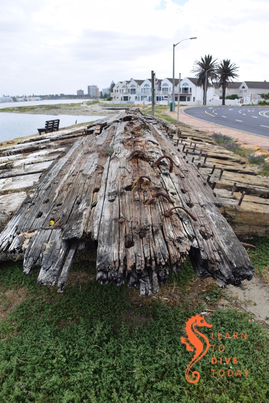
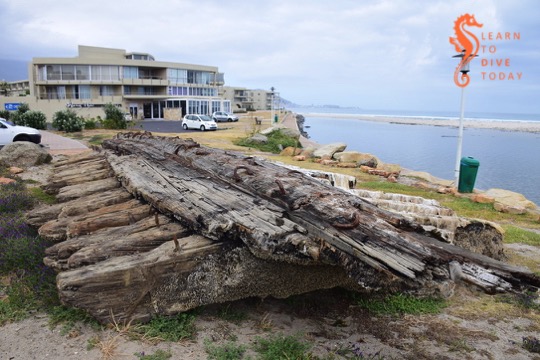
The new, and hopefully final location of the wreck is just next to the small parking area outside the Lagoon Beach hotel and Wang Thai restaurant. It’s entirely accessible at all hours of the day and night, and there are promises of interpretive signage to share the wreck’s history with passers by.

Tube worms cover the lower portion of the wreck

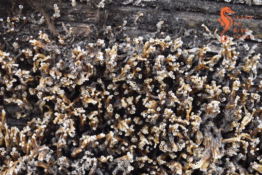
I went to visit the wreck a week after she was moved. Dried pond weed still covers some of the planking, and thousands of tiny tube worms cover the lower part of the structure that was submerged (I can’t tell what kind – most likely Ficopomatus enigmatus, the estuarine tube worm that thrives in brackish water).

It’s great that the Commodore II is now firmly on the radar as one of Cape Town’s historic shipwrecks, worthy of preservation. I’ll be updating my ebook to reflect her new location before year-end. Meanwhile, read about her chequered history here.

Friday photo: Farø south bridge

One of the Farø Bridges

The Danish island of Farø is connected to the islands of Falster and Zealand (Copenhagen is on Zealand) by two bridges called (surprise!) the Farø Bridges. They’re lovely. Here’s one of them, the south bridge, just under two kilometres long, seen from a rest stop on Farø. It is a cable-stayed bridge and joins Falster to Farø.

Friday photo: Great Belt bridge

The Storebælt (Great Belt) bridge

The beautiful 18 kilometre long Storebælt bridge joins two of the many islands that make up the nation of Denmark. We missed the official viewing location, but managed to see it from below on the island of Odense during our July 2011 visit to Denmark. Driving over it was an ecstatic experience (Tony drove, while I gave myself whiplash looking out of all the car windows). The toll fee, however, was worth weeping over.

Friday photo: Life preserver

Life preserver in Denmark

I took this photo just beneath the Storebælt (Great Belt bridge), an engineering masterpiece and thing of beauty which joins the island of Zealand (where Copenhagen is) to the island of Odense, all part of Denmark. You can see one of the bridge legs in the background. TrygFonden (written on the life preserver) is a health and safety organisation.

Stumbling upon the Kiel canal

Tony checking out a small container ship (taken with my fisheye)

I have a faint obseession with container ships. It emerged – when Tony and I were driving back to Amsterdam from a family holiday in Denmark in July of 2011 – that he has an obsession with the Kiel Canal. This is a sign that we were meant to be together (one of several such). Fortunately it was on our route, and we stumbled across it mostly by accident owing to my poor navigation skills.

Signboard proclaiming the presence of the Kiel Canal

Called the Nord-Ostsee-Kanal in German, it is the world’s busiest artificial waterway, and is about 100 kilometres long. It slices across the top of Germany, joining the North Sea to the Baltic. This saves considerable sea distance for shipping. The access point that we found was a short walk down a tarred road to a viewing platform near a bridge, which I think is the New Levensau High Bridge.

Peaceful Kiel Canal
Peaceful Kiel Canal

It was quiet and calm when we arrived, but only remained thus for a moment…

We hung about a bit, and were soon rewarded with a nice container ship called Eilbek approaching from the Baltic Sea direction. It just fit under the bridge!

The Eilbek departs the vicinityorth Sea direction
The Eilbek departs the vicinity

To get an idea of how much traffic the Kiel Canal experiences, go to this AIS tracking site, type “Kiel Canal” in the box on the top left where it says “Go to Area”, and marvel.


Exploring: Sunny Cove

Tony has been wanting to dive Sunny Cove practically since he first set foot in Cape Town, having read in an old book on South African dive spots (The Dive Sites of South Africa – Anton Koornhof) that seahorses had been found there in the sea grass. Tony loves seahorses.

I put my foot down, repeatedly, until it was the dead of winter and the Sharkspotters website told me that not a single great white had been seen patrolling the coast for a couple of months. Sunny Cove is at the end of Jagger Walk, the catwalk that runs along the western edge of Fish Hoek Bay. It’s the site of at least one fatal munching by a great white, and I didn’t want to take any chances.

Sunny Cove railway station
View from the bridge over the railway line towards the dive site

It’s a shore entry, and we parked on the road at the bottom of the steps over the railway line. It’s quite a strenuous walk over the bridge with all your kit on. We spent a while figuring out where to get in – you have to clamber over some rocks, and make your way through dense kelp before getting to a clear spot. Once we decided where to get in, we were glad to be wearing thick wetsuits, otherwise we would have been scraped and scratched quite liberally! There is a huge submerged concrete block just where we got in – at first I tried to swim over it, but realised it was in only a few centimetres of water, and made my way around it. (Fortunately there was no one on the shore with a camera!) Cape Town shore diving is hard on your kit.

Sunny Cove
Our entry point is on the far left, almost out of the photo, where the straight piece of rock sticks out.

The actual dive site is aptly named. The sun streams in through the kelp, and the sea floor looks a lot like Shark Alley near Pyramid Rock – lots and lots of urchins, with pink-encrusted rock formations. We saw a little bit of sea grass, and spent a lot of time examining it for signs of life, but didn’t even find a pipe fish, let alone seahorses! There’s a lot of invertebrate life on the rocks – feather stars, brittle stars, abalone – and we saw quite a few fish.

We did see the deep channel that the sharks probably use to get in and out of Fish Hoek Bay. We were hoping to spot the beacon that records movements by tagged sharks past Sunny Cove, but no luck there. We did not explore much to the south of our entry point – that’s on the to do list (along with more sea horse hunting) for another shark-free day.

Verdict: Shallow, easy dive but a fairly tricky entry and exit. Infrequently dived, so rather more lush and unspoiled than busier sites. Videos of our dive are here and here.

[youtube=http://www.youtube.com/watch?v=DaxvdFG4Fdg&w=540]

Dive date: 4 July 2010

Air temperature: 21 degrees

Water temperature: 13 degrees

Maximum depth: 10 metres

Visibility: 6 metres

Dive duration: 32 minutes