Mythbusting solutions to Cape Town’s water crisis

Here’s an only half serious take on some of the suggestions I’ve heard to deal with Cape Town’s water crisis. These are solutions that I’ve seen proposed to magically, quickly save us from the catastrophic water shortage we are facing in Cape Town, usually by people reluctant to adjust their own water consumption to face the new normal. They are mostly ridiculous, and fun to mythbust using an extremely low-level bastardisation of Fermi estimation. (They’ve put me fondly in mind of Prof Hahn’s first year applied maths lecture in which he instructed us to estimate the volume of a cow by assuming – to make the maths easier – that it was spherical in shape.) I digress:

Can we tow an iceberg from Antarctica to melt for fresh water?

PhD student Neil Malan wrote a detailed explanation of why this is an infeasible (I’m being polite here) idea. Here’s a highlight…

Icebergs are large, and heavy. Therefore, in order to get a decent-sized (say 20 km long) iceberg it is estimated that some twenty large oceangoing tugs would be needed to move the iceberg the 6 000 odd kilometres from the Southern Ocean to Cape Town. This would be done at a speed of approximately one knot, thus making a journey of 250 days to reach the Cape and losing about 40% of its mass along the way.

… and here’s the whole article, which I urge you to read in order to get a sense of some of the scales (distance, volume, time) involved in such a proposal.

Does anyone sane and respectable think it can be done? Well, yes, actually – salvage master Nick Sloane (who righted the Costa Concordia, and who is a singularly impressive individual), thinks it is a feasible solution. Judge for yourself who is right – listen to his comments on Cape Talk radio and weigh them up against Neil Malan’s reservations.

Has it been done anywhere else? No, but some people in Dubai are talking about it, and expert consensus is that it’s pretty much impossible.

Theewaterskloof dam (Cape Town's primary water supply) in August 2017, 24% full
Theewaterskloof dam (Cape Town’s primary water supply) in August 2017, 24% full

Can we supply water to Cape Town using water tankers from other parts of South Africa?

Let’s do some maths. At current water usage rates, Cape Town is using more than 500 megalitres (million litres) of water per day. Let’s round it down to 500 for ease of calculation. If we divide 500,000,000 by 24 (to get usage per hour), and then by 60 (to get usage per minute), and again by 60 (to get usage per second), we arrive at a figure of 5,787 kilolitres per second. (Just pause on that for a moment – it’s a big number.)

If a tanker truck can carry 20,000 litres, it’ll take one of these trucks arriving about every three seconds, around the clock, to provide enough water for the city. Let’s generously assume that such a truck can be filled, drive to Cape Town, offload its water, and return to its point of origin (which would have to be somewhere far away that has spare water – an entirely mythical place in South Africa at present) in 24 hours. If we multiply 24 hours by 60 minutes by 60 seconds divided by three (we only need a truck every three seconds, remember), we’ll need 28,800 tanker trucks running continuously to provide Cape Town’s water.

I can tell you, with great certainty, that there aren’t that many tanker trucks in South Africa, let alone unused tanker trucks with nothing to do other than drive back and forth bringing water to the Cape. (Who’s going to pay for this? Where will the water come from? Where will they park? Another story.) One water tanker costs in the ballpark of R1.3 million. A few tens of them are usually procured at a time, not thousands.

Think I’m being greedy asking for 500 megalitres per day? Let’s halve our water usage; then we’ll only need 14,400 tankers on the road. Think we should also rather calculate using 40,000 litre trucks? Then we’ll only need 7,200 tankers. STILL TOO MANY.

Can we build a long pipe from the Orange River to Cape Town, to bring us water?

Assuming that there was spare water in the Orange River (there’s not – almost all of it is allocated to agriculture), could we build a pipeline to bring it to Cape Town? We’re talking a distance of 600-800 kilometres here.

Pipelines are expensive and it’s hard to pull numbers out of the air, so let’s look at a South African example. The Gariep pipeline, from the Gariep dam to Mangaung in the Free State, was proposed in 2015. It was to be 180 kilometres long and to cost R2 billion. It would transport 130 megalitres of water per day (about 20 percent of Cape Town’s current daily water usage).

By 2016, it was a “multi-billion Rand” project, hadn’t been started yet, and was projected to take more than five years to complete. The engineers’ website says it is to cost R4.5 billion.

If we multiply R4.5 billion by three, because our imaginary pipeline is at least three times the length of the Gariep pipeline, we arrive at a figure of 13.5 billion ZARs. For a mere 8.5 billion ZARs, we could build a desalination plant that would supply 450 megalitres per day. This is about two thirds of recent usage, and our actual target usage under level 6B water restrictions, using water that is definitely there (the sea) instead of water that isn’t (spare capacity in the Orange River). We could buy some chocolate with the R5 billion left over.

Could we build a 600 kilometre pipeline quickly enough to help our current situation? These things take a long time, and in South Africa we don’t have a track record of speedy project completions, corruption-free tender processes, and trouble-free execution of projects. We can look to this 40 kilometre pipeline near Durban for an idea of how long a big project like this could take; phase two of the project was commenced in 2012, and completion “was expected” by mid-2017. So for a 600 kilometre project, are we looking at 75 years to completion?

Can’t we dig the dams deeper so that they store more water?

Cumulative annual rainfall at our weather station in Sun Valley

The problem is not that the dams are not deep enough, it’s that there has not been enough rain to fill them. Here’s a helpful interview with the regional head for the Department of Water and Sanitation.

While we’re talking about this, when building a dam the engineers don’t typically go out and dig a big hole to fill with water. Dams are typically structures that block river valleys, allowing the river to flood the land behind the dam wall as the natural course of the water flow is obstructed. Whatever used to be on the land – farms, homes, wildlife – can’t be there any more.

A cubic metre of soil weighs at least 1.5 tons (obviously depends on the type of soil), and removing this would make space for one kilolitre of water. Theewaterskloof  Dam has a capacity of 480 million cubic metres (480 million kilolitres) of water.

What does this much water look like? Well, if we put our Fermi estimation hats on and approximate the dimensions of just the flat-topped part of Table Mountain by a right rectangular prism with dimensions of 1,000 metres (height), 1,000 metres (length) and 200 metres (width), we arrive at a volume for the iconic flat bit of Table Mountain – minus the skirt that sprawls towards Camps Bay, Rondebosch, and the City Bowl, and the Twelve Apostles and the rest of the chain that spreads down the peninsula – of 200 million cubic metres. We could thus hide Table Mountain twice over (broken into bits, obvs) in Theewaterskloof dam and it still wouldn’t be full.

Theewaterskloof dam was built at the head of a valley where farmers once grew grape vines. You can see the dead vines sticking out of the sand now, when you visit the dam. There isn’t one big river that runs into the dam, but numerous small streams as well as the general runoff from the catchment area around the dam, which is about 500 square kilometres in extent. If the total volume of the dam had to be excavated, rather than using a natural valley, you’d be left with at least 720 millon tons of earth to dispose of. A Table Mountain-sized problem.

But the United Nations says that water is one of my human rights, so the taps can’t run dry!

Ignoring the fact that if there is no water, then your “human right” can’t be catered for, it is instructive to read what the UN actually says about the right to water and sanitation. I refer you to this media brief (pdf), which sets it out in some detail, with examples.

The amount of water you are entitled to is not unlimited. Between the UN and South Africa’s Constitutional Court the recommended amount is somewhere between 25 and 50 litres, and it is not required to be free (it simply has to be “affordable”). Page 7 of the media brief corrects some of the common misconceptions around this human right.

Anyway – my view of human rights, particularly in a country as thoroughly damaged as South Africa, where I am emphatically not one of the most vulnerable or disadvantaged members of the population, is that my rights are to whatever I can provide for myself. There are far more needy and less able people than I, and in terms of state or municipal or welfare assistance, their needs have to come first.

Enough already

This is ridiculous, and I’m tired. Solutions to water crisis? Use less water. No, less than that. Practise radical personal responsibility. No one is coming to help, except perhaps – if you are extremely lucky – friends and neighbours. Collect rainwater in your personal capacity so that you rely less on municipal supply. Recycle water in your home (grey water for flushing, hand washing, gardening), and continue to do this even if things return to some semblance of the way they were three years ago. Think about how you will cope with Day Zero.

In my inexpert opinion the city should immediately start to build capacity to treat and re-use waste water. In the long term, solutions such as desalination on a medium to large scale, and (if carefully managed) tapping into the aquifers will become very important to ensure the city’s water resilience as the climate in the Western Cape becomes drier and windier. Desalination as a short term, small-scale, temporary solution is laughable. So is drilling into the aquifers without knowledge of their capacity, without proper plans to recharge them (fascinating witchcraft), and without a scientific understanding of how much water it is reasonable to abstract on an ongoing basis. Peace out.

What causes the brown water at Muizenberg beach?

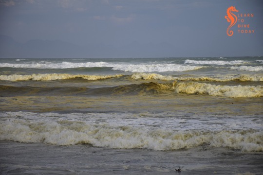
Capetonians are familiar with the tea-coloured water that runs in our mountain streams. Most people know that the brown colour comes from tannins, leached naturally from the indigenous fynbos vegetation. Perhaps less well known is the reason for the brown water that is sometimes seen in the surf zone along Muizenberg beach, stretching all the way to Strandfontein, Monwabisi and beyond.

Tea-coloured water at Muizenberg

The most frequent explanations that are offered on social media are, of course, pollution, “raw sewage”, and the like. This is not the reason for the brown water, and it does not necessarily impact the water’s safety or healthfulness for humans to swim in.

Like False Bay’s famous colour fronts, the reason for the brown waves at Muizenberg beach turns out to have much to do with the topography of False Bay, particularly of the kilometres-long beach at its head (Muizenberg-Strandfontein-Macassar-Monwabisi), and something called a diatom.

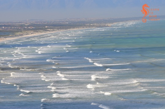
View of Muizenberg showing patches of brown water

Diatoms

Diatoms are a type of phytoplankton (plant plankton or microalgae). They are single celled, usually symmetrically shaped organisms that multiply by dividing in half at a constant rate. Their cell walls are made of silica, SiO2. Chicken keepers and gardeners may be familiar with diatomaceous earth – this is made up of the fossilised shells of ancient diatoms.

Diatoms are what are called primary producers or autotrophs, meaning that they generate organic material from carbon dioxide and other inorganic nutrients (for example nitrates and phosphates), through the process of photosynthesis, which uses light as an energy source. Primary producers sit at the base of the food chain and all life relies on them, directly or indirectly. Everything else produces organic material from other organic material (such as diatoms).

I am telling you all about diatoms because the brown water at Muizenberg contains an accumulation of a diatom that you can call Anaulus australis Drebes et Schultz the first time you mention it, but usually just Anaulus australis, or Anaulus for short. There are several members of the genus Anaulus, but usually just one tends to be dominant at each beach where these accumulations occur, and Anaulus australis is the main species found along the South African coast.

Analaus are pillow-shaped diatoms. If you wanted to see what an individual Anaulus diatom looked like, you’d use a microscope, but when enough of them are in one place, they can be seen to change the colour of the water. There’s a picture of them under a microscope at the bottom of this webpage (they also occur in Brazil). They occur at beaches with particular topograhical characteristics, which explains why you haven’t seen them at Camps Bay, Kogel Bay, or Scarborough.

At hospitable beaches, the diatoms are always there, spending much of the time lying dormant in the sand behind the surf zone. A proportion of the diatom population is able to survive for relatively long periods (estimated to be more than two months) like this, in the dark on the seabed, not photosynthesising or dividing, until the correct meteorological conditions arise for an accumulation. But first – what sorts of beaches are hospitable to Anaulus?

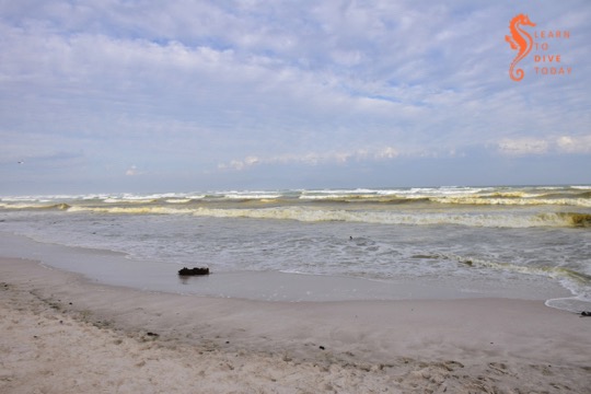
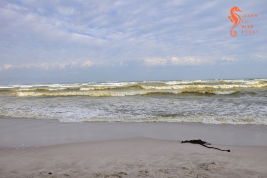
Brown water in the surf zone at Muizenberg

Topographical conditions

There are five physical features of coasts that are prone to diatom accumulations. They are:

  1. a high-energy sandy – not rocky – shore
  2. a long beach, more than 4 kilometres in extent
  3. the presence of rip currents
  4. a surf zone at least 150 metres wide
  5. a nutrient source close to the surf zone (often an unconfined aquifer overlaid by a dune field)

Muizenberg and Strandfontein beach tick all these boxes. The beach stretches from Surfers Corner all the way across the top of False Bay to Monwabisi, a distance of over 20 kilometres. It is a high energy beach, meaning that it is exposed to large waves and strong winds, and is not protected by any offshore features such as sandbars or headlands that might reduce the force of the waves. Rip currents do occur at the beach, and both these and the exceptionally wide surf zone – wider during south easterly winds in summer – can be observed from the mountainside on Boyes Drive. (A rip current is like a hidden river flowing out to sea from the beach. The Sydney Morning Herald has an excellent visual explainer of rip currents here.)

The head of False Bay where Muizenberg is situated is incredibly nutrient-rich, much of it thanks to urbanisation. The canalised Zandvlei estuary – the only vaguely functional one on False Bay’s coast – is situated a short distance down the beach, and supplies nitrates, phosphates and other nutrients to the surf zone. Many of these nutrients are technically pollutants, added to the river further upstream. The Cape Flats Waste Water Treatment plant at Strandfontein also discharges 200 million litres of treated water per day (under normal, non-drought circumstances) via a canal onto Strandfontein beach. This is essentially an artificial estuary for Zeekoevlei. This waste water has spent some time working its way through the settlement ponds at Strandfontein, but is nevertheless rich in ammonia and other nutrients, and Anaulus accumulations are a very common sight in the surf around this discharge point. The dunes that run along Baden Powell drive overlay a high water table, and groundwater seepage – specially during times of heavy rainfall – may also leach nutrients out of the ground and into the surf zone.

Meteorological conditions

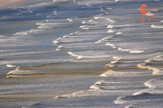
The meteorological conditions required for an Anaulus accumulation involve strong wind and a large swell. These act together to create rough sea conditions, which stir up the dormant diatoms from the ocean floor. The diatoms adhere to air bubbles in the surf zone, staying suspended in the water column, which is when you would notice the water turning brown. Exposed to light, they awaken from their dormant state and start to photosynthesise, take up nutrients, divide and multiply. The presence of rip currents creates an onshore-offshore flow all along the beach. This forms a semi-closed ecosystem, and the diatoms are essentially trapped in gyres in the waves. Longshore currents that run parallel to the beach transport Anaulus cells out of the surf zone at one end, and bring fresh (sea)water in at the other end of the beach.

It may seem surprising that anything manages to accumulate in the waves of a beach, but the surf zone is actually quite retentive, meaning that things that end up there often tend to stay there. (Incidentally, this is why it’s a terrible idea to discharge the byproduct of reverse osmosis seawater desalination –  a super-salty brine – into the surf zone. It must be discharged offshore so that it can disperse and mix with the surrounding water.)

Diatoms in the surf zone at Muizenberg

You’ll notice that, contrary to what you may have seen when large amounts of plankton are under discussion, I’ve been using the word “accumulation” instead of “bloom” to talk about Anaulus. This is deliberate, because of the constant presence and constant rate of division of the diatoms. When the water goes brown, it doesn’t mean that Anaulus is suddenly multiplying faster than usual. It means that it’s all been gathered together in patches, is exposed to light and therefore photosynthesising (at its usual steady rate), and is thus more visible than it was when it was lying on the ocean floor.

Anaulus at Muizenberg in November 2017

The human factor

You may also be thinking that everything I’ve said about the nutrients that Anaulus requires to survive and thrive points to the fact that humans – and pollution – are ultimately responsible for these brown-water plankton accumulations at Muizenberg. Well yes, in a way. But accumulations of Anaulus australis and related species have been observed and documented for well over 100 years at suitable beaches around the world, and are a natural phenomenon.

Yes, we are providing more nutrients to the False Bay diatom population than they would otherwise have received without human settlement in the greater Cape Town area, but these accumulations would likely occur regardless. They are certainly more intense now than they would have been in the past, but estuaries are nutrient-rich locations even when not surrounded by a large city. Furthermore, the water table is high on the Cape Flats, which would supply nutrients to the surf zone regardless of whether humans lived nearby.

Anaulus is in fact performing a vital and useful function by mopping up the excess nutrients that the city discharges in the ocean. The mass of diatoms – primary producers – also provides a food source to bivalves such as mussels, and other invertebrates. We can be grateful that the excess nutrients that urbanisation directs towards the ocean at the head of False Bay leads only to accumulations of harmless diatoms, rather than to frequent occurrences of harmful algal blooms that can kill marine life and exacerbate respiratory problems in humans.

Muizenberg during a diatom aggregation

Sources

Most of the original scientific study on surf zone diatoms in South Africa was done by a group of researchers (primarily M Talbot, Eileen Campbell and Guy Bate) from the University of Port Elizabeth, working at the Sundays River Beach in the Eastern Cape. I did quite a bit of reading to research this post, but you can start with this paper for a description of the topographical characteristics of beaches where surf zone diatoms accumulate. The first few chapters of this Masters thesis also provide a good overall survey of what is known about surf zone diatoms.

Putting knowledge into practice

Not every instance of brown, foamy water at the beach will be an Anaulus accumulation. On the west coast of South Africa, for example, there are no beaches where Anaulus occurs, but you may see brownish foam that is the result of heavy wave action frothing up organic matter in the surf (nothing sinister – there is a lot of organic material in the ocean). A clue to help you distinguish diatom accumulations from other brown-water phenomena – apart from running through the checklist of required beach characteristics above – is that an Anaulus accumulation doesn’t stretch much beyond the back of the surf zone. If the brown water stretches beyond the furthest row of waves, it’s probably something else. (And this seems like an apposite time to remind you that sewage looks whitish-grey, not brown, when it’s pumped out into the ocean.)

The number of beaches worldwide where surf zone diatom accumulations occur is so small – less than 100 – that Odebrecht et al could enumerate them in a 2013 paper. I hope this helps to convince you that the brown water at Muizenberg beach (and beyond) is something special and interesting, not to be feared. Go surfing!

Stumbling upon the Kiel canal

Tony checking out a small container ship (taken with my fisheye)

I have a faint obseession with container ships. It emerged – when Tony and I were driving back to Amsterdam from a family holiday in Denmark in July of 2011 – that he has an obsession with the Kiel Canal. This is a sign that we were meant to be together (one of several such). Fortunately it was on our route, and we stumbled across it mostly by accident owing to my poor navigation skills.

Signboard proclaiming the presence of the Kiel Canal

Called the Nord-Ostsee-Kanal in German, it is the world’s busiest artificial waterway, and is about 100 kilometres long. It slices across the top of Germany, joining the North Sea to the Baltic. This saves considerable sea distance for shipping. The access point that we found was a short walk down a tarred road to a viewing platform near a bridge, which I think is the New Levensau High Bridge.

Peaceful Kiel Canal
Peaceful Kiel Canal

It was quiet and calm when we arrived, but only remained thus for a moment…

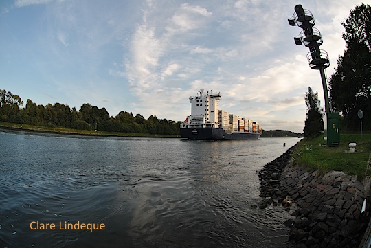
We hung about a bit, and were soon rewarded with a nice container ship called Eilbek approaching from the Baltic Sea direction. It just fit under the bridge!

The Eilbek departs the vicinityorth Sea direction
The Eilbek departs the vicinity

To get an idea of how much traffic the Kiel Canal experiences, go to this AIS tracking site, type “Kiel Canal” in the box on the top left where it says “Go to Area”, and marvel.