On the way back from Big Bay at the end of the Lighthouse Swim, Tony and I stopped by the Seli 1 and then checked out the ships waiting outside Table Bay harbour. One of them was the Golar Penguin, a LNG carrier.
Golar Penguin
She is under the flag of the Marshall Islands. This is a flag of convenience (though, it seems, quite a reputable one), and if you want to know more about the legal implications of the fact that 40% of all world shipping by deadweight tonnage fly Panamania, Liberian or Marshall Islands flags, I suggest you pick up the excellent book The Outlaw Sea by William Langewiesche.
Bow of the Golar Penguin
Seals on the bulbous bow
Front view of Golar Penguin
Most interesting to us, however, was the small group of Cape fur seals basking in the sea on the ship’s bulbous bow, which was sticking quite far out of the water because she seemed to be unladen. The purpose of this bow shape, which is only effective on ships above a certain size that cross large bodies of water, is to reduce drag, increase speed and to improve fuel efficiency.
Seals in the sun
The seals, however, like it as a haul out spot. Who are we to argue?
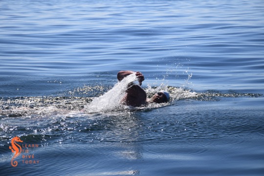
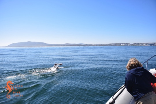
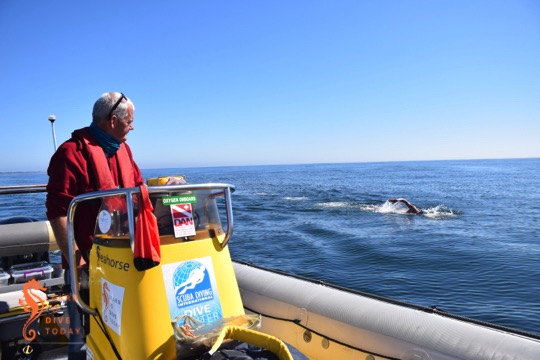
This year we were once again a support boat for the annual Freedom Swim, from Robben Island to Big Bay. This is a 7.5 kilometre route, held every year in April, this year on the 11th. The water is, as you can imagine, often quite cold, and this affects the number of swimmers who are able to complete the route.
Catherine keeps an eye on Ned
This year we supported Ned Denison, an American swimmer who bases himself out of Cork in Ireland (for swimming purposes). I read about his Cork Distance Week – a terrifying bootcamp of open water swimming – a few years ago and was interested to meet him. He has done every open water distance swim you can imagine, including a swim across False Bay from Rooi Els to Miller’s Point.
The press boat filming Ned
Apart from a very misty start, the day was perfect with no wind and extremely calm seas. Tony kept a good line straight from Murray’s Bay harbour on Robben Island to Big Bay on the Table Bay coastline. Ned didn’t stop once, and finished the swim in under two hours. It was a great day to be out on the boat, and fantastic to watch such a renowned swimmer in action.
At the beginning of this year, the NSRI launched the SafeTrx smartphone app. It is available in other countries, and the NSRI brought it to South Africa. I have been using it since February. It has taken a bit of getting used to with a few missteps on my part, but it now provides great peace of mind whenever I go out to sea. The app is a journey planner for boaters, with the capability of activating emergency contacts should you not return to port on time.
The app is available for iOS and Android systems. Skippers using the app can register a vessel (or more than one vessel) with the app (mine is Seahorse). You can provide a photo of the boat, its registration number, its radio call sign, and whether it has an emergency beacon (EPIRB or similar). When you depart for a trip, you select which vessel you are travelling in, how many passengers, what type of trip you’re doing (diving, cruising, safety, etc.), and an estimated time of arrival. You can also specify the route you’re taking by including waypoints on the trip map.
Once you’ve set up your journey, you can text it to your emergency contact(s). On your return to port, you re-open the app, close your journey, and have the option to text your emergency contacts again to let them know you’re home safely. These are screen shots from Clare’s phone showing the start and end of a trip with six people (including me) on board:
Text messages generated by SafeTrx app
The SafeTrx app comes with a login to the SafeTrx website, which allows you to review your journeys online. You can actually see updates in real time; Clare took this screen shot from the website when I was out at Duiker Island in Hout Bay. When I started to return to Hout Bay harbour, the boat icon could be seen moving (jerkily) towards the harbour entrance.
The website information also allows you to evaluate the directness of the sea routes you follow, which is important when supporting open water swimmers, and gives useful statistics about how far you’ve travelled on the boat and for how long.
Viewing journeys on the SafeTrx website
The first time I used the app, I didn’t set my ETA (estimated time of arrival) correctly, and left it on the default value, which is fifteen minutes after the current time. Not long after that time had elapsed, Clare (my emergency contact when she’s not on board) received a phonecall from Maritime Rescue stating that I was overdue and had she been in contact with me? She assured them that she had and that I was a first time user of the app, hence the mistake! We were extremely impressed by the speedy response, and glad to know that the system works so efficiently. Needless to say I have not made the same mistake again.
I encourage you to visit the NSRI website for more information about the use of the app, including download links. If you see me on the jetty and want to take a look at the app set up on my phone, please feel free to ask!
We were able to get in the water twice over the Easter weekend: really early on Saturday in False Bay before the wind, and then again on Monday. Monday turned out to be a great day with very little wind. It was however cold, 9 -10 degrees, and we dived the BOS 400, Tafelberg Reef and the seals out of Hout Bay.
Saturday’s dives were interesting but perhaps not fun in the conventional sense of the word – we two back to back at Shark Alley so a film crew could visit the cowsharks. There was not a cowshark to be seen until the end of the second dive, when the divers encountered two dead sharks with what looked like extensive bite marks all down their bodies. We sent the pictures to one of the local scientists running the sevengill cowshark project in False Bay. She observed that the sharks had not been dead long (their eyes were intact, and these would be the first thing to be nibbled by fish), and that the absence of hooks and typical treatment by fishermen suggested that humans were not involved.
Monday launch in Hout Bay, with burned mountains behind us
Weekend plans
This weekend shows great potential for good clean water almost everywhere. There is no swell forecast, and light winds. On Saturday we are supporting Ned Denison at the Robben Island Freedom Swim so there is no diving planned.
On Monday we are supporting the Swim for Hope around Cape Point, so we are making up for all the windy days that have stopped us taking the boat out this summer.
Mozambique trip
We will need to close bookings for the trip at the end of April. There are three spots still available – let me know if you want more information. We’re away from 28 June until 4 July, traveling via Durban.
Sunday: Boat or shore dives in False Bay, to be confirmed
Simon’s Town harbour looking pristine last Sunday
We dived last weekend in False Bay. The conditions were great for being out and about on the boat, but the visibility was a little mediocre. In fact we should have just dived under the jetty in Simon’s Town, as the viz was not too bad there. The good thing is that the ocean always has a surprise ready and we were treated to the sight of a lesser spotted, light blue, teeth-chattering frozen Andre and his henchman Jesse as we brought the boat in after the first dive.
Jesse and Andre under the jetty
This weekend sees the first Aqualung Fun Day in Gordon’s Bay on Saturday. Our boat will be there and we are hoping for good conditions. Here’s how to get there. On Sunday we will dive from Simon’s Town but at this point it is difficult to be sure whether we will shore dive or boat dive. It is a spring tide, and low tide will be close to midday plus the wind forecast is a little hectic. If you’d like to be on standby to dive, reply to this mail or send me a text message.
Our Sunday afternoon trips down to the jetty in Simon’s Town, ice cream in hand, have become more interesting since the unveiling of a beautiful bronze statue of a navy standby diver. For about a week before the big day, the statue was concealed by a huge wooden box, leading to much speculation!
The statue was unveiled just before Christmas 2014, and was sculpted by Otto du Plessis. Its design, fundraising to pay for it, and eventual unveiling to the general public was a lengthy process that was pursued by a group of dedicated volunteers, drawn from the fraternity of ex SA Navy divers.
Even a lobster hides at the foot of the statue
The attention to detail on the Standby Diver is remarkable
Shackle on the Standby Diver statue
Abalone
A piece of history immortalised in bronze
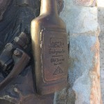
Old Brown Sherry!
Octopus on the Standby Diver
The Standby Diver
The Standby Diver plaque
The Standby Diver’s snorkel
The Standby Diver’s fins
A tour of the SA Navy diving facility in Simon’s Town at a DAN day in 2013 showed us just what a high standard of training these divers receive. They are a credit to South Africa and to the navy. You can read more about the statue here. It’s already a very popular landmark, and groups of divers and passers-by often pose for photographs with the stoic, bronze gentleman keeping watch at the end of the jetty.
Spring low tide at the jetty allowed us to poke around on the beach in the corner below Jubilee Square. From there we had this beautiful view across the yacht basin, with the jetty in the foreground.
The words “organised crime” don’t typically intrude into our privileged Capetonian lives (if you can afford to scuba dive recreationally, you’re privileged), but in reality there are networks operating on our doorstep, and many of our activities as scuba divers actually cause us to cross paths with these syndicates. Sometimes it is a very literal crossing of paths, and other times it’s simply sharing the same space as individuals who are advancing the interests of a criminal organisation.
Khalil Goga, a researcher who has been focused on organised crime since 2009, published a report on the Western Cape’s illegal abalone trade for the Institute of Security Studies in August 2014. This paper can be seen as a companion to Jonny Steinberg’s 2005 ISS report on the illicit abalone trade in South Africa. While Steinberg’s paper deals with poaching’s socioeconomic and political origins and has a broad geographic focus within South Africa, Goga lays out the structure of poaching operations from harvesting the resource to its arrival in Asia, with special reference to the Hangberg community of Hout Bay.
Half sunken in Hout Bay harbour
The state of Hout Bay harbour – with corrupt or no access control, no checking of catches by Marine and Coastal Management or monitoring whether vessels are compliant with SAMSA regulations, and sunken ships at their berths – visually demonstrates how easy it is to base a poaching operation out of this location. The individuals who do the hard work of diving, driving, and carrying abalone over the mountain are drawn from the communities surrounding the harbour. Despite the involvement of these impoverished and sidelined communities, however,
The abalone trade has moved from largely being in the hands of a marginalised population to one that is ‘dominated by outside opportunists’. It has evolved from an informal activity by fishers into ‘a highly organised commercial fishery run by organised criminal syndicates’.
Read the complete ISS report here (PDF). It’s clear, easy to understand without glossing over the complexity of the issue, and absolutely fascinating. If you would rather read a shorter article on the abalone trade emanating from Hout Bay, you can try this M&G piece.
Ice Patrolis a four part BBC documentary featuring the British naval ice breaking ship HMS Endurance, named for Sir Ernest Shackleton’s polar exploration ship that set sail in 1914. Endurance is much like our SA Agulhas II, except the South African polar research ship is run by the department of fisheries, whereas the British entrust theirs to the navy. The producers of the BBC series Frozen Planet made use of Endurance as a platform for filming in the polar regions – ships with ice breaking capabilities and high tech steering systems are relatively uncommon.
The series starts with Endurance docked in the Falkland Islands, and follows her and her crew through a couple of Antarctic missions during a period of several months in late 2008. They land at South Georgia Island, where Shackleton sought rescue for his crew from Norwegian whalers based there, and visit the old whaling station (as an aside, strangely, we don’t see a single live whale throughout the ship’s time at sea). A group of marines re-enact Shackleton’s trek across the island as a training exercise, which proves to be a tough proposition even with modern camping and climbing equipment, skis, high quality outerwear, and the support of a helicopter for part of the trip. Scientists take sediment cores in order to study climate change, and others conduct an aerial survey of seal populations. We meet a variety of penguins, and members of the crew even pay a visit to a US Antarctic base (Palmer Station) – which has a gift shop!
The final episode is concerned with a catastrophic flood in the engine room that occurred in the Strait of Magellan off Chile (fortunately close enough to help that the civilians on board – the cameramen and producers for the documentary, one assumes – could be airlifted to safety). The ship was nearly lost. The documentary series presents this incident (and other minor whoopsies) in an embarrassingly dramatic light, but it seems that the flooding of Endurance was really that serious. She is going out of service in 2015, the damage she sustained being too costly to repair properly.
After reading Alfred Lansing’s book on Shackleton’s original expedition to the Antarctic, I have been obsessed with the icebound regions of the planet, and this is why we ended up watching Ice Patrol. Perhaps it’s not what everyone would consider gripping television, but we found it very enjoyable. The scenery is beautiful, and the glimpses of shipboard life and navy formality (sitting around on the bridge wearing hats, extreme formality mixed with corporate jargon when addressing one another…) are quite entertaining.
You might be able to get a copy here if you’re in South Africa, otherwise go here.
I took this photo standing on the end of the Simon’s Town jetty. As an amateur cloud appreciator (cloudspotter would imply that I can remember the names of anything other than cumulonimbus), I enjoy any landscape involving ocean and clouds. I think I am an immensely irritating companion on days like this, like a three year old constantly drawing my companions’ attention to the same thing. In this case, CLOUDS! Look at how much depth and interest it gives to the landscape.