I am a notoriously bad navigator. Shockingly, embarrassingly inept. On the navigation dive for my advanced course, I swam a triangle instead of a square. Tony tried to console me by telling me that “a triangle is a more difficult shape to swim”, but doing it by accident doesn’t make it any less pathetic.
With this in mind, he gave me the PADI Navigation Specialty for my birthday last year. It’s been a great help. The manual deals with basic compass navigation, and then progresses to more advanced topics. It covers marking a particular spot – taking a bearing off several landmarks so that you can find it again – as well as estimating distances and bearings in the presence of a current.
Tools of the navigation trade
The course involves three dives on which specific skills are practised. I learned about natural navigation, using a Nav-Finder to follow an irregular path, and lots about compass navigation in general. It’s made me a more confident underwater navigator, which can only be a good thing!
Tony and I recently attended the annual Christmas party of False Bay Underwater Club (FBUC), of which we are members. Tony was a member of the Durban Undersea Club while he stayed up north, but it’s my first experience of belonging to any sort of club (except, of course, for the Cape Town Girls Club, of which I was a founder member at the age of ten) – let alone a diving club.
There are numerous benefits – among them, cheap gear hire, free air fills on club days (Wednesday evenings), and access to courses at reduced rates. FBUC offers CMAS courses to its members and other interested parties, and Tony, Kate and I recently completed a compressor operator course there. The club periodically performs ocean cleanups (Simon’s Town yacht basin was their last one), and is involved in several social responsibility projects – for example, the gifts and baby supplies that we brought to the Christmas party are to be donated to the Beautiful Gate in Crossroads, which cares for babies, children and families in the community, many affected by HIV/AIDS.
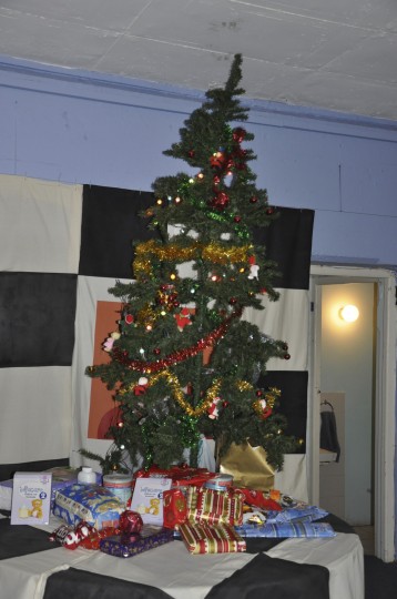
FBUC Christmas tree
FBUC also holds weekly club dives – there’s a mailing list that informs members where to meet, what day (usually Sunday), and what time. Tony and I have not had a chance to explore any of the Oudekraalshoreentrysites yet, and that’s been on hold while we sort out a wetsuit for him that isn’t quite as highly ventilated as his current one, but we look forward to tagging along on some club dives to learn the shore entry dive sites we don’t know in Cape Town.
The thing we have been enjoying most, however, is the access that club membership gives us to the accumulated knowledge and experience of the other members. There are members who are photography gurus, those who manufacture their own gear and accessories, those who repair and service dive kit, mapping and dive site gurus, and experts on marinelife. It’s here that we got to check out Diver Propulsion Vehicles (DPVs) first hand. (Tony immediately added one to his Christmas list… high hopes!)
Monty checking on the progress of the snoek on the braai
We’ve learned a huge amount just chatting to other members over a drink (or a fish braai) on a Wednesday evening at the club. It’s been lovely to meet interesting, like-minded people who love the ocean and exploration and are happy to discuss it.
Everything I’ve described regarding False Bay Underwater Club also applies – one way or another – to the other main diving club in Cape Town, Old Mutual Sub Aqua Club (OMSAC). We accompanied some of their members on a cleanup dive on Robben Island earlier this year.
It’s not particularly cheap to be a member of a dive club, but I think it’s been well worth it so far. Not so much for the gear hire and air fills – Tony has his own gear and requires air fills FAR more often than once a week – but for the other reasons I’ve mentioned.
Atlas of Dive Sites of South Africa & Mozambique – Fiona McIntosh
Atlas of Dive Sites of South Africa and Mozambique
This is a brand new release from MapStudio and diver-author Fiona McIntosh. McIntosh specialises in outdoor adventure topics (hiking routes, caving, etc.) and she has produced a handy volume detailing the best dive spots around South Africa in some detail. The “atlas” moniker is accurate: the volume includes maps of the whole area, with inserts depicting the dive sites in question. This potentially enables experienced divers to explore sites independently of a local operator.
There are only a few sites featured in each area, but the dive sites featured are the “best” in each location. They have been selected on the basis of safetly, and pristine condition. There are additional sites listed, along with their locations, but maps and reviews only appear for the short list of top dive sites in each place.
There are lots of interesting sidebars detailing local attractions (for example, a shyshark and catshark feeding dive offered in Mossel Bay, seahorse hunting in Knysna, the chokka dive in Port Elizabeth every August, and shark cage diving in False Bay at Seal Island). The dive site descriptions include details of what marine life can be seen, and the nature of the entry (important for shore dives). Made me want to put on my kit and get in the water again as soon as possible! The weekend is too far away…
I was interested to see the quality of diving offered on the south coast in locations such as Plettenberg Bay. Apparently there are also some super dives in Hermanus, though no permanent dive operator there. The atlas definitely made me want to travel!
At the back of the atlas is a section on marine life, by SURG‘s Georgina Jones. It’s a whirlwind tour, of necessity, since it covers not only the Cape but the entire South African coastline.
Dive Atlas launch function
The book also includes contact details of the various dive operators around the country, as well as general dive tourism information. I was pleased to note that in the Cape Town section, McIntosh includes the web address of Peter Southwood’s wikivoyage page on diving around the Cape Peninusla and False Bay for those who require more detailed information.
Tony and I attended the launch last week, at the NSRI Station at the Waterfront (very cool venue!) and enjoyed catching up with the diving establishment of Cape Town. Fiona gave a whirlwind tour of diving in Southern Africa (the Mozambique section of her talk – and of the atlas – made me drool), and Georgina did a natural history tour of Cape diving for us. We are definitely very fortunate here in the Cape!
I found a website run by the University of the Aegean that records live ship movements across much of the world’s oceans. The data is collected using Automatic Identification System (AIS), a transponder-based monitoring system mandated by the International Maritime Organisation (IMO) for all ships over 299 tons. These transponders transmit the vessel’s speed, course, dimensions, name and current position.
The result is this map. Check it out – you can zoom in to specific areas. Click on the little ship icons to get details of the vessel and (often) a photograph. Totally awesome!!
If you explore the site a bit you can also find lists of which vessels using the AIS system are in port at the moment. Here’s Cape Town.
Cape Town has an amazing stretch of coastline. Knowledge of dive sites, beaches and where to dive is greatly enhanced by decent scale hydrographic charts. Besides their value to mariners and the general boating public whereby you have detailed information on what perils lurk below the surface waiting to wrench a piece out of the keel of your boat, they also offer great insight to where you may find interesting dive sites not listed on the “popular” dive site list. All you need to do is sign up for a few of the major dive centre newsletters to see that most of them go to the same places at the same time week after week.
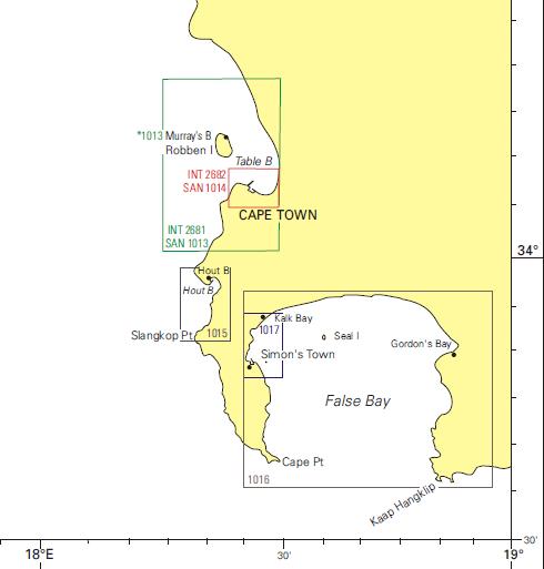
Hydrographic charts covering False Bay and the Cape Peninsula
SAN 1016, scale 1:50 000 which covers the entire False Bay area
SAN 1015, scale 1:15000 covering Kommetjie, Hout Bay up to Sandy Bay
SAN 1013, scale 1:36 000 covering the Table Bay area including Robben Island.
My favorite is SAN 1017 as this gives great detail on the areas I dive the most. The area it covers has many dive sites, some undived sites and many less popular sites. Any spot that seems interesting from the road, the dark patches you see from the beach could be kelp, rocky reef or some other manmade item from years gone by. Marine life gathers anywhere it can find even the slightest protection from predators, so a small kelp forest, an old submerged bridge foundation, or a wreck all attract marine life, many species setting up residence.
These maps are published by the SA Navy Hydrographic Office, and can be purchased from Chart World (telephone 021 419 8814) and Charts International (telephone 021 419 7700), both located on the foreshore in Foregate Square at the entrance to the harbour. The full chart catalogue can be found here.
I’ve mentioned Peter Southwood a couple of times, in the context of a set of web pages that he’s largely responsible for. It’s on the Wikivoyage website, which (like Wikipedia) is a collaborative project where many contributors work together to create something useful. In this case, the something useful is a worldwide travel guide.
Peter’s project is to catalogue the dive sites of South Africa. The area that has received most attention thus far is the Cape Peninsula and False Bay – he has a list of the dive sites in each area, and most of the Cape Town have at least a skeleton article in place.
There is a detailed article on Diving in South Africa, and one for Diving the Cape Peninsula and False Bay. The introductory article lists dive operators, describes local climate, weather and sea conditions, lists reference books on the marine life in the area, describes the marine ecology, recommends equipment configurations, covers any legal requirements such as permits, details emergency services available, and provides safety and travel tips. The overview article also lists the dive sites in the area, with links to the detailed page on each site. This information is very useful for tourist divers coming to South Africa, but also contains a host of information useful to the local diver.
Peter Southwood maps the sites in a lot of detail. He has a small polystyrene boat, painted red, with a waterproof container containing a GPS mounted on it. This is towed behind him like a buoy as he dives (often solo) and maps the sites. Particular projects of his with very comprehensive reference pages and detailed maps are Long Beach in Simon’s Town (including a fantastic navigation route that covers a series of highlights of the site), and the Partridge Point area, where a location has been named Peter’s Pinnacles in his honour.
The dive site pages are very comprehensive, covering everything you could possibly wish to know about each area:
position (GPS co-ordinates are usually given)
naming convention and origins of the name of the location
depth
visibility – what the usual range is
bottom topography and composition
expected conditions, including tips on when it’s good to dive there
access information (boat or shore, with detail on the entry point if it’s a shore dive)
facilities on site (for shore dives) such as parking, restrooms and showers
marine life in the area
features of the site – caves, overhangs, pinnacles, air traps and so on
photography information – what equipment is recommended, and what subjects are promising
routes around the site
hazards
recommended equipment (e.g. an SMB, a light, etc.)
required skills to dive the site – sometimes relatively shallow sites are only suitable for more advanced or experienced divers… Shark Alley comes to mind!
The Cape Peninsula and False Bay wikivoyage page is Tony’s and my go-to guide whenever we want to dive a new site, as well as a good reference to familiar places. Even the articles on well-known sites give new insights or tips on what can be found there. The evolving nature of the online medium means that we check back often for updates and improvements to the articles. The Partridge Point article is a case in point – it’s undergone huge development in recent months.
This project deserves as much publicity as it can get – it’s incredibly impressive and useful, and reflects years of work on the part of Peter Southwood. The fact that he has made it freely available online is very generous. What’s more, the collaborative nature of the site it’s hosted on means that other divers can create accounts and contribute to the detailed information already there.
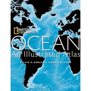
Ocean: An Illustrated Atlas – Sylvia Earle & Linda Glover
Ocean: An Illustrated Atlas
I eyed this book for weeks and weeks before finally succumbing and placing an order online (get it here). It’s a National Geographic publication, and – as one would expect – absolutely magnificent. It’s mainly about the detailed ocean maps, but there are articles on each ocean, and on topics such as the impact of climate change, conservation and deep sea exploration.
Sylvia Earle is incredibly impressive – a living legend (according to both the US Library of Congress, and yours truly). She has a long history of work in and on behalf of the world’s oceans, holds several diving records (she’s hardcore) and is a world-renowned scientist and explorer. She’s an expert on the subject of oil spills, and is – I think – soon set to release a book on the latest BP-led fiasco in the Gulf of Mexico. She also holds the designation of Explorer-in-Residence at National Geographic, which sounds both like a contradiction in terms and like the coolest job in the world.
I spent most of my time in this book poring over the maps, and picking up nuggets of (potentially) useful information about where the sea is deep, where it’s shallow, and what the bottom profile of a whole host of international dive sites is like. There are water temperature maps (myriad rainbow shades showing the spectrum from freezing cold water in indigo, to lovely warm water in red). There are fascinating charts showing the position of the various (and multitudinous) information collecting devices (buoys and others) all over the world’s oceans. I also learned, thanks to one of the detailed double-page maps, that the ocean’s currents are far more complex than primary school geography led me to believe… The update on the state of oceanography and deep sea exploration was also fascinating. I was awed to discover that the average – that’s AVERAGE – depth of the world’s oceans is about 4 kilometres. As recreational open-circuit scuba divers, we can go to 40 metres with the appropriate qualification. That’s hardly scratching the surface.
This is a magnificent coffee table book, but not just one that you’ll leave lying about and not return to over and over. The impression it left me with was twofold: one, how vast and varied our oceans are. The second impression was of how little we know about what’s under the waves. That is kind of thrilling!
You can obtain a copy here if you’re in South Africa, otherwise click here.
Are you interested in the physical processes of the earth’s oceans? Currents, waves, and how the oceans got to be the way they are? Fear not, I have just the reading list for you. Dig in!