Diving has been a little on the lean side the past few weeks but that is all set to change tomorrow. The wind dies, the swell is hammering another beach somewhere else, and the forecast is for day time temperatures above 20 degrees. Okay maybe 20.1 degrees, but still, it’s up there. Saturday is going to be best for diving as Sunday looks wild and windy again, so we will launch from Simon’s Town jetty at 10.00am and 12.00pm. I do know there were reports of 15 metre visibility and 4 metre visibility on the same day in the same bay, so I reckon we will go out and look for some clean water and then decide where we dive.
On Monday evening there is a public event at the Bluebird Garage in Muizenberg where a number of speakers will give short illustrated talks about the wonder that is False Bay. There are more details on facebook! We’d love to see you there.
Mountains in the Sea: A Celebration of Table Mountain National Park – John Yeld & Martine Barker
Mountains in the Sea
Mountains in the Sea is a beautiful coffee table book showcasing the beauty and history of Table Mountain National Park, which stretches the entire length of the Cape Peninsula, in between the urban areas. There is minimal text by veteran environmental journalist John Yeld, and the photographs are from both authors as well as from the archives and other sources.
This is a really gorgeous volume that manages to inform by the choice of images as well as via the text. I have a list of new places I would like to explore after reading it, and half an ambition to do the Hoerikwaggo Trail. It is a wonderful souvenir for visitors, but also an excellent reference for Capetonians who want to get the most out of the natural environment on their doorstep.
You can get a copy of the book here. There is also a pocket-sized volume which has been of great utility to me during my explorations of Table Mountain National Park, but it is harder to find.
Saturday: Early double tank dive, weather permitting
Spring is around the corner and we are still waiting for the weeks of crystal clean water we should have in False Bay. There have been very few real winter visibility days this winter. (I may have had this complaint last winter too…)
Buffels Bay at Cape Point
The weekend looks to be another let’s wait and see situation. Tomorrow’s wind should improve the visibility, which is currently not that great, for some good diving early on Saturday. By midday on Saturday the wind is strong and on Sunday it will be close to gale force. I hope to launch early on Saturday for a double tank dive but it’s low tide at 9.00 and there is a forecast 3 metre, 14 second swell so deeper sites will be better. I would imagine that the Roman Rock area will be our best bet. Text or mail me if you want to be on the list for Saturday and I will make a call tomorrow afternoon.
The wharf street parking at the Simon’s Town jetty is a paid parking area again from tomorrow. A slip is placed on your car when you arrive… Make sure the time is recorded correctly.
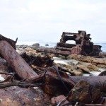
The second visible shipwreck along the Cape Point Shipwreck Trail, about three kilometres from the start in the Olifantsbos parking area, is the Nolloth. She was a Dutch coaster carrying a cargo of (mostly) liquor, and struck a submerged rock (probably Albatross Rock, nemesis of many ships) off Olifantsbos in April 1965. Her captain ran her aground to save the cargo and prevent loss of life. Customs officials swiftly salvaged the cargo!
Engine block of the Nolloth
The Nolloth lies just in the waves at high tide. We visited a couple of hours after high tide, and were able to walk all the way around the wreckage without getting our feet wet. She lies at an angle, with much of her seemingly buried in the sand. Her engine block is partially exposed, and for the mechanically minded, prolonged examination of the cogs and gears will be rewarding.
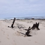
Ribs of the Nolloth
The wildness of the location lends a very special quality to this wreck that is lacking in Cape Town’s visible shipwrecks that are situated in more urban environments – RMS Athens comes to mind. It is a remote and very beautiful spot, but would be possessed of far fewer benign qualities on a dark and stormy night.
There are some fantastic pictures of the Nolloth in Brian Wexham’s Shipwrecks of the Western Cape, taken, I suspect, within 20 years of her running aground. There is far more of her visible – she looks like a ship on the beach rather than a ship in the beach! There is also evidence of some low wreckage in the shallows that might still be visible when the tide is at its nadir, but I would caution against too much barefoot exploration of rockpools unless the water is very clear and your tetanus shots are up to date.
The Nolloth on the beach south of Olifantsbos
The Nolloth signals the point at which one turns back along the Shipwreck Trail to head towards Olifantsbos once more. Tami, Maria and I spent a wonderful morning on the Shipwreck Trail exploring the Thomas T Tucker and the Nolloth. As an aside, I would like to apologise to the resident chacma baboons for disturbing the peace when I realised that – with the help of a Slingsby Map – I had in fact successfully navigated us (along a marked and named trail, mind you) to not one, but two shipwrecks.
The first boiler of the Thomas T Tucker you’ll come across
If you’re a fan of visible shipwrecks, may I recommend the Shipwreck Trail in the Cape Point section of Table Mountain National Park? I’ll write a separate post just about the trail, but this post and the one that follows (about the Nolloth) concern two shipwrecks, high and dry on the shore, that can be see on the route.
Three large pieces of the Thomas T Tucker on the rocks
TheSS Thomas T Tucker was an American-built Liberty ship. These cargo vessels were of a standardised design and were built in great numbers, and at great speed, during World War II. They were used to transport war materiel to the Allied troops, and this is what the Thomas T Tucker was busy doing when she found herself off Olifantsbos in November 1942. She was on her maiden voyage from New Orleans to Suez, hugging the coast in a thick fog for fear of German U-boats.
The Thomas T Tucker’s second boiler, high on the beach
When she ran aground on 27 November (our wedding anniversary!), her captain reported that the ship was aground on Robben Island, which is over 40 kilometres to the north. The ship’s compass was found to be out by 37 degrees, which may have contributed to the accident.
The wreck of the Thomas T Tucker
Receding tide on the Thomas T Tucker
Funnels from the midsection of the Thomas T Tucker
Shards of metal high on the beach
Pieces of the Thomas T Tucker on the shore
The “bonus wreckage” of the Thomas T Tucker further along the beach
Today the Thomas T Tucker is beautifully spread out on a beach about two kilometres from the parking area at Olifantsbos, inside the Cape Point Nature Reserve. She was 135 metres long, so there was a lot of ship to distribute. There are some great pictures in Shipwrecks of the Western Cape by Brian Wexham, from (I think) the 1980s. They give a good idea of how the wreck has deteriorated.
You will first come upon one of her boilers, high up on the beach, close to a small headland. If you look back the way you’ve come (first photo, above) you can see Misty Cliffs, Scarborough and – perhaps – Slangkop Lighthouse. Beyond that she is in several large pieces on the rocks, and higher up the beach. A third (bonus!) section of wreckage lies a couple of hundred metres further along the Shipwreck Trail (also called the Thomas T Tucker trail), so isolated from the rest of the wreck that I at first thought that it came from a different ship.
The “bonus wreckage” of the Thomas T Tucker further along the beach
We visited the wreck of the Thomas T Tucker an hour or two after high tide. At low tide, all the pieces of the wreck are accessible; we could not reach the most distant piece without getting our feet wet! There is some wreckage that isn’t visible, lying in the shallow water, which you can visit on a scuba dive if you get the appropriate permission to have dive gear on a boat within the exclusion zone around Cape Point. We were lucky to have fairly dramatic skies for photography. The way in which the wreck is scattered is a testament to the exposed nature of this coast, and the power of the Atlantic Ocean.
Sunday: Launching from Simon’s Town jetty at 9.00 am, weather permitting
Finding enough dive related content for a newsletter is difficult when there has been little to no diving! The south easter has blown the entire week and is not yet done with us. It has flipped to north westerly and back and is forecast to do so a few times more in the next week. It is as though winter is on its way out, but fighting not to leave! I had a look at the Atlantic today thinking that the water might be clean after so many days of south east wind, but it is still very green.
This weekend does not look all that great. There is a fair amount of south easter on Saturday so I don’t think diving will be much good. There is less wind on Sunday, but some rain in the forecast.
Windmill Beach in better days
Dive plans
Stay dry on Saturday, launch from Simon’s Town jettyon Sunday at 9.00 am (to be confirmed mid-Saturday). I am out on False Bay tomorrow and will have a better idea of whether and where we will dive on Sunday. If you have a preference and/or want to get on the boat, email or text me.
There has been a lot of permit checking lately so please make sure yours is current. If it isn’t, I have temporary permits available on the boat.
Sunday: Boat dives – if the weather forecast turns out to be wrong!
We had a good dives last weekend, and our shore dive at Fisherman’s Beach was pretty pleasant. The site is very dependent on the size of the shore break – if it’s too big you end up barrel rolled on the sand before you even get started! Fortunately is was not that bad and we had a good 6 metre viz. A couple of photos here, on facebook.
Briefing at Fisherman’s Beach
Thanks to Jan de Bruyn who took this picture of the boat last Friday, when I was out in False Bay!
Boating in False Bay, pic by Jan de Bruyn
Surfing
I am sure the best option for tomorrow will be watching some of the best big wave surfers give Dungeons or Sunset Reef a ride, we will launch from Hout Bay at 10.00 am for this.
The dive conditions for the weekend look a little poor. There is strong north north westerly wind forecast for Saturday, too much for pleasant boating, and a fair amount of south easter for Sunday. The water should be very clean given the last few days of wind so I am open to the idea of launching on Sunday if the wind turns out to be a little less than it is currently forecast to be.
To provisionally book or put your name on the list in case we launch on Sunday, you can SMS, Whatsapp, call, email, call on a landline, send a carrier pigeon, or (preferred method) pop in with cake. You decide.
Date to diarise
As part of the South African Shark and Ray Symposium happening next month, there’s a fantastic speaker evening being held on Monday 7 September. Check out the details on facebook here. There are some riveting speakers who will take you through False Bay’s fauna from the microscopic to the massive (orcas, anyone?)!
Earlier this month we returned from our second ever dive trip to Ponta do Ouro. (It was my third time there – on my first trip, in 2009, I wasn’t qualified to dive yet, and met my future husband, where he was diving and skippering five times a day and living in a reed hut. I still sometimes feel guilty for having a part in him leaving this little piece of paradise.) We flew to Durban. A shuttle transported us to the Kosi Bay border post, where we were met by Mike of Blowing Bubbles Diving. Mike drove us and our luggage over the dunes into town, and dropped us at Planet Scuba, where we would stay for the week.
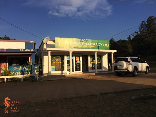
The new(ish) pharmacy at Ponta do Ouro
Planet Scuba is situated on top of the hill that overlooks Ponta’s central square. Since my last visit (I think), a pharmacy has opened on the corner (pictured above), and later in the trip we purchased a much needed decongestant there (for a fairly princely sum, but beggars can’t be choosers).
Every morning we would walk down the steps to the road that leads to the beach, and head towards the point to meet up with the boat for diving. After diving, we would either walk back or get a ride on the back of the Blowing Bubbles bakkie. We breakfasted between dives, and then returned to the beach. The dives in Ponta do Ouro are boat dives, and the skippers launch the boat off the beach through the waves. There was almost no swell while we were there, so the surf launches were quite tame!
Laurine and Esther descending
We dived for five days, most of us doing ten dives in total. We contemplated a dolphin trip with Dolphin Encountours, but reports were that boats were only seeing one or two dolphins, if any, and the trips cost more than a dive so we carried on diving instead. We were so, so lucky to see a huge pod of dolphins at the end of our last dive, near Ponta Malongane. On our first dive that day we had seen big schools of baitfish near the surface, and the dolphins had probably come to the area for feeding. We weren’t allowed to get into the water with them, but they swam past the boat for ages, and we heard them breathing as they passed by. Tony and I stuck our cameras over the side of the boat, and it turned out there were many more dolphins underwater than we could see on the surface.
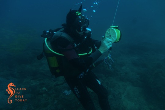
Batman takes the reel
The pace of life was very mellow. We dived, ate, slept, and repeated various iterations of that sequence. We admired the community of friendly dogs down at the beach. We enjoyed hungry cats and condensed milk milkshakes at Neptune’s, with a view over the Motel do Mar (where we stayed on our last trip) to the beach. We had a healthy and delicious lunch at Mango above the Dolphin Centre, and got thoroughly soaked by a tropical rainstorm on the way back to Planet Scuba. Christo, Esther and Laurine sampled the “chemical s***storm in a glass” (I quote Esther) that is Ponta do Ouro’s famous R&R (rum and raspberry). Strangely, none of them wanted any more…
Mike, the owner/operator at Blowing Bubbles
Esther is OK!
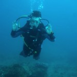
Here’s one picture to prove that I dived!
CvS is very serious about safety stops
Laurine dancing at the safety stop
Riding back to the border over the dunes
The diving was excellent. The water temperature was 23 degrees, and we had (apparently mediocre for Ponta) visibility of about 10 metres, sometimes more. This was very acceptable to us as Capetonians. The reefs are teeming with life, and all of us saw something new. Laurine was enchanted by a turtle, Tony spent most of his dives upside down with his head in crevices in the reef, Christo directed all of us to exciting discoveries with his torch and pigsticker (a metal kebab stick slash pointer that must have a different name but I don’t know it), and Esther maintained her sense of wonder and calm as she brought up the rear of our little group on most dives. On one of the dives a very strong current gave us opportunities to use our SMBs, which was an excellent learning experience and a reminder of how important a safety sausage is, no matter where you are diving.
The air temperature was warm, the wind hardly blew, and for a while we could forget that at home in Cape Town it was cold, frequently dark, and overflowing with commitments and obligations. We returned the way we had come, but feeling a little more ready to cope with the rest of the Cape winter. We’ll be back in a couple of years, Ponta!
(I’ll share some little videos and more photos from the trip over the next couple of weeks.)
After our team of relay swimmers completed the Lighthouse Swim, Tony and I made our way back towards Granger Bay via a meandering route that included a search for the buoy marking the Seli 1, off Blouberg beach. We did not find it.
The Seli 1 under Table Mountain
What we did find was quite disturbing: a hissing, pulsating patch of water beneath which the rusty wreckage of the Seli 1 lies, very close to the surface. There was no wind and very little swell when we were searching for the wreck, and initially we thought it was a school of baitfish disturbing the surface in that way. Fortunately we approached the spot slowly, because if we’d ridden over the wreckage this would be a different kind of blog post altogether.
The sea reveals the Seli 1
We rode around the spot as close as we dared, watching the image of the objects below us on the sonar. The buckled plates of the wreck, where the SA Navy divers did their work with explosives to reduce it below the waterline in 2013, were clearly visible. The wreckage – particularly the shallowest part pictured above – is a definite hazard to any boat with a keel. We couldn’t tell exactly how much clearance there is between the top of the shallowest part of the wreck and the surface, but it didn’t seem to be more than half a metre. I hope it’s more than that, and I also hope that SAMSA pays attention to our request for a replacement marker buoy on the wreckage to warn ships (but considering how many channels of communication I had to try before not getting some kind of error, I haven’t a lot of hope).
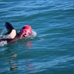
The Lighthouse Swim is a 10.5 kilometre trip northwards up the Table Bay coastline, from Milnerton lighthouse to Big Bay. The swimmers plunge through the breakers at Milnerton, which is similar to the start of the Swim for Hope at Diaz Beach, and quite intimidating. This year’s Lighthouse Swim took place on 7 June, and we supported a relay team of four swimmers.
Reg jumping in
Our job was to keep an eye on their safety in the water (we had a SharkShield on board), and to guide the swimmers along the most direct route possible to Big Bay. Things can go downhill very quickly when a swimmer gets too cold, and it is vital to act quickly if the onset of hypothermia is suspected.
The four relay team members at Big Bay
Table Bay
Maryna on form
Reg and Nicky after tagging one another
Nicky in action
The team prepares to finish together
Fortunately there was no wind and the swell was manageable. The water was cold, hovering at 11-12 degrees, and other participants in the race dropped out one by one. Only the fastest individual swimmers would manage to complete the course in such challenging conditions. The conditions were good for relay teams, as members could warm up on board in between dips in the ocean. There was ample hot chocolate to go around. Our team of four were full of smiles and enthusiasm, and did a fantastic job, finishing as the second relay team in 2h45.
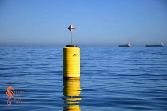
Shipping traffic
Upon arrival at Big Bay, all four team members had to jump into the water so that they could finish the swim together.