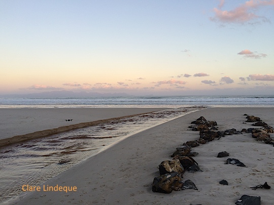
What causes the brown water at Muizenberg beach?

Capetonians are familiar with the tea-coloured water that runs in our mountain streams. Most people know that the brown colour comes from tannins, leached naturally from the indigenous fynbos vegetation. Perhaps less well known is the reason for the brown water that is sometimes seen in the surf zone along Muizenberg beach, stretching all the way to Strandfontein, Monwabisi and beyond.
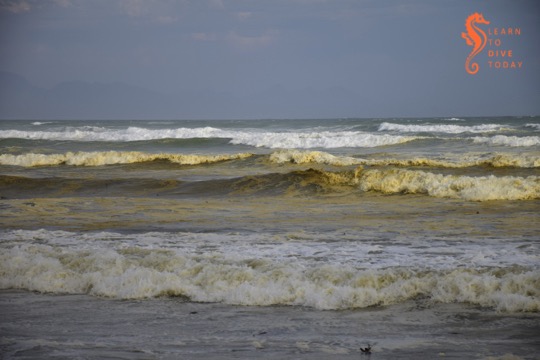
Tea-coloured water at Muizenberg

The most frequent explanations that are offered on social media are, of course, pollution, “raw sewage”, and the like. This is not the reason for the brown water, and it does not necessarily impact the water’s safety or healthfulness for humans to swim in.

Like False Bay’s famous colour fronts, the reason for the brown waves at Muizenberg beach turns out to have much to do with the topography of False Bay, particularly of the kilometres-long beach at its head (Muizenberg-Strandfontein-Macassar-Monwabisi), and something called a diatom.
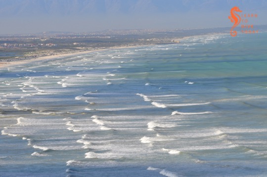
View of Muizenberg showing patches of brown water

Diatoms

Diatoms are a type of phytoplankton (plant plankton or microalgae). They are single celled, usually symmetrically shaped organisms that multiply by dividing in half at a constant rate. Their cell walls are made of silica, SiO2. Chicken keepers and gardeners may be familiar with diatomaceous earth – this is made up of the fossilised shells of ancient diatoms.

Diatoms are what are called primary producers or autotrophs, meaning that they generate organic material from carbon dioxide and other inorganic nutrients (for example nitrates and phosphates), through the process of photosynthesis, which uses light as an energy source. Primary producers sit at the base of the food chain and all life relies on them, directly or indirectly. Everything else produces organic material from other organic material (such as diatoms).

I am telling you all about diatoms because the brown water at Muizenberg contains an accumulation of a diatom that you can call Anaulus australis Drebes et Schultz the first time you mention it, but usually just Anaulus australis, or Anaulus for short. There are several members of the genus Anaulus, but usually just one tends to be dominant at each beach where these accumulations occur, and Anaulus australis is the main species found along the South African coast.

Analaus are pillow-shaped diatoms. If you wanted to see what an individual Anaulus diatom looked like, you’d use a microscope, but when enough of them are in one place, they can be seen to change the colour of the water. There’s a picture of them under a microscope at the bottom of this webpage (they also occur in Brazil). They occur at beaches with particular topograhical characteristics, which explains why you haven’t seen them at Camps Bay, Kogel Bay, or Scarborough.

At hospitable beaches, the diatoms are always there, spending much of the time lying dormant in the sand behind the surf zone. A proportion of the diatom population is able to survive for relatively long periods (estimated to be more than two months) like this, in the dark on the seabed, not photosynthesising or dividing, until the correct meteorological conditions arise for an accumulation. But first – what sorts of beaches are hospitable to Anaulus?

Brown water in the surf zone at Muizenberg

Topographical conditions

There are five physical features of coasts that are prone to diatom accumulations. They are:

  1. a high-energy sandy – not rocky – shore
  2. a long beach, more than 4 kilometres in extent
  3. the presence of rip currents
  4. a surf zone at least 150 metres wide
  5. a nutrient source close to the surf zone (often an unconfined aquifer overlaid by a dune field)

Muizenberg and Strandfontein beach tick all these boxes. The beach stretches from Surfers Corner all the way across the top of False Bay to Monwabisi, a distance of over 20 kilometres. It is a high energy beach, meaning that it is exposed to large waves and strong winds, and is not protected by any offshore features such as sandbars or headlands that might reduce the force of the waves. Rip currents do occur at the beach, and both these and the exceptionally wide surf zone – wider during south easterly winds in summer – can be observed from the mountainside on Boyes Drive. (A rip current is like a hidden river flowing out to sea from the beach. The Sydney Morning Herald has an excellent visual explainer of rip currents here.)

The head of False Bay where Muizenberg is situated is incredibly nutrient-rich, much of it thanks to urbanisation. The canalised Zandvlei estuary – the only vaguely functional one on False Bay’s coast – is situated a short distance down the beach, and supplies nitrates, phosphates and other nutrients to the surf zone. Many of these nutrients are technically pollutants, added to the river further upstream. The Cape Flats Waste Water Treatment plant at Strandfontein also discharges 200 million litres of treated water per day (under normal, non-drought circumstances) via a canal onto Strandfontein beach. This is essentially an artificial estuary for Zeekoevlei. This waste water has spent some time working its way through the settlement ponds at Strandfontein, but is nevertheless rich in ammonia and other nutrients, and Anaulus accumulations are a very common sight in the surf around this discharge point. The dunes that run along Baden Powell drive overlay a high water table, and groundwater seepage – specially during times of heavy rainfall – may also leach nutrients out of the ground and into the surf zone.

Meteorological conditions

The meteorological conditions required for an Anaulus accumulation involve strong wind and a large swell. These act together to create rough sea conditions, which stir up the dormant diatoms from the ocean floor. The diatoms adhere to air bubbles in the surf zone, staying suspended in the water column, which is when you would notice the water turning brown. Exposed to light, they awaken from their dormant state and start to photosynthesise, take up nutrients, divide and multiply. The presence of rip currents creates an onshore-offshore flow all along the beach. This forms a semi-closed ecosystem, and the diatoms are essentially trapped in gyres in the waves. Longshore currents that run parallel to the beach transport Anaulus cells out of the surf zone at one end, and bring fresh (sea)water in at the other end of the beach.

It may seem surprising that anything manages to accumulate in the waves of a beach, but the surf zone is actually quite retentive, meaning that things that end up there often tend to stay there. (Incidentally, this is why it’s a terrible idea to discharge the byproduct of reverse osmosis seawater desalination –  a super-salty brine – into the surf zone. It must be discharged offshore so that it can disperse and mix with the surrounding water.)
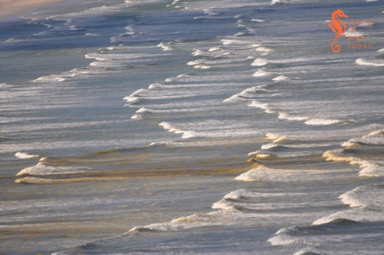
Diatoms in the surf zone at Muizenberg

You’ll notice that, contrary to what you may have seen when large amounts of plankton are under discussion, I’ve been using the word “accumulation” instead of “bloom” to talk about Anaulus. This is deliberate, because of the constant presence and constant rate of division of the diatoms. When the water goes brown, it doesn’t mean that Anaulus is suddenly multiplying faster than usual. It means that it’s all been gathered together in patches, is exposed to light and therefore photosynthesising (at its usual steady rate), and is thus more visible than it was when it was lying on the ocean floor.
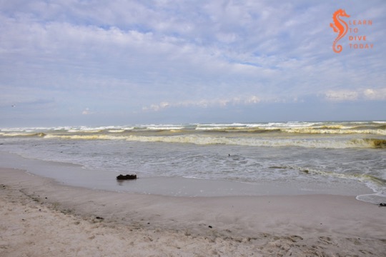
Anaulus at Muizenberg in November 2017

The human factor

You may also be thinking that everything I’ve said about the nutrients that Anaulus requires to survive and thrive points to the fact that humans – and pollution – are ultimately responsible for these brown-water plankton accumulations at Muizenberg. Well yes, in a way. But accumulations of Anaulus australis and related species have been observed and documented for well over 100 years at suitable beaches around the world, and are a natural phenomenon.

Yes, we are providing more nutrients to the False Bay diatom population than they would otherwise have received without human settlement in the greater Cape Town area, but these accumulations would likely occur regardless. They are certainly more intense now than they would have been in the past, but estuaries are nutrient-rich locations even when not surrounded by a large city. Furthermore, the water table is high on the Cape Flats, which would supply nutrients to the surf zone regardless of whether humans lived nearby.

Anaulus is in fact performing a vital and useful function by mopping up the excess nutrients that the city discharges in the ocean. The mass of diatoms – primary producers – also provides a food source to bivalves such as mussels, and other invertebrates. We can be grateful that the excess nutrients that urbanisation directs towards the ocean at the head of False Bay leads only to accumulations of harmless diatoms, rather than to frequent occurrences of harmful algal blooms that can kill marine life and exacerbate respiratory problems in humans.
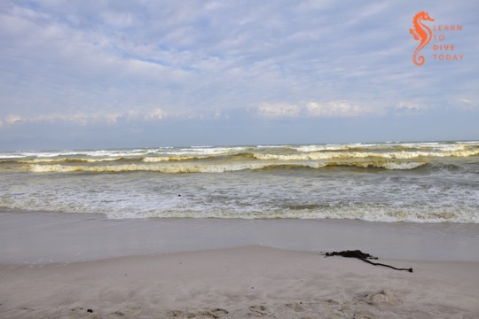
Muizenberg during a diatom aggregation

Sources

Most of the original scientific study on surf zone diatoms in South Africa was done by a group of researchers (primarily M Talbot, Eileen Campbell and Guy Bate) from the University of Port Elizabeth, working at the Sundays River Beach in the Eastern Cape. I did quite a bit of reading to research this post, but you can start with this paper for a description of the topographical characteristics of beaches where surf zone diatoms accumulate. The first few chapters of this Masters thesis also provide a good overall survey of what is known about surf zone diatoms.

Putting knowledge into practice

Not every instance of brown, foamy water at the beach will be an Anaulus accumulation. On the west coast of South Africa, for example, there are no beaches where Anaulus occurs, but you may see brownish foam that is the result of heavy wave action frothing up organic matter in the surf (nothing sinister – there is a lot of organic material in the ocean). A clue to help you distinguish diatom accumulations from other brown-water phenomena – apart from running through the checklist of required beach characteristics above – is that an Anaulus accumulation doesn’t stretch much beyond the back of the surf zone. If the brown water stretches beyond the furthest row of waves, it’s probably something else. (And this seems like an apposite time to remind you that sewage looks whitish-grey, not brown, when it’s pumped out into the ocean.)

The number of beaches worldwide where surf zone diatom accumulations occur is so small – less than 100 – that Odebrecht et al could enumerate them in a 2013 paper. I hope this helps to convince you that the brown water at Muizenberg beach (and beyond) is something special and interesting, not to be feared. Go surfing!

Visible shipwrecks: SS Kadie

The Kadie on the beach, further parts of the wreck in the rockpools

The mouth of the Breede River is a fascinating and beautiful location. There’s a treacherous sandbar (more on that just now). There are wide, natural vistas. There are sleepy holiday villages on each side of the river mouth. There’s an additional little frisson of excitement related to the fact that bull sharks use the Breede River, and must be passing by all the time (right?!).

When Tony and I were in the area for a spring break, we explored the area. I wanted to see whether I could find the remains of SS Kadie, a steaam-assisted sailing ship that is an integral part of the history of the area. The Kadie was built in Scotland in 1859, for the specific purpose of navigating the Breede River and up and down the coast, as a trading vessel. She did venture out to sea on longer voyages, on one occasion carrying a cargo of ostriches to Mauritius. (You can read a lot more about her history, and that of the Barry family who operated her, here.)

On 17 December 1865 the Kadie ran aground and sank while attempting to cross the sandbar at the mouth of the Breede River. She is easy to find, but you should visit at low tide. Take the turnoff to the river mouth from the dirt road to Infanta. It’s a small sign and easy to miss! Descend the wooden staircase onto the beach, and walk right. You will soon see pieces of the Kadie on the beach, in the shallow rockpools, and out in the surf zone. Best to go at low tide, or at least not at the peak of high tide.

Looking down the beach to the Kadie

If you’re interested in visible shipwrecks, check out my ebook Cape Town’s Visible Shipwrecks: A Guide for Explorers!

Bookshelf: The Control of Nature

Today and tomorrow I’ll tell you about two books I read recently: The Control of Nature, and The World Without Us. They both deal with man’s impact on the environment, but not in the same way as the conservation-related books that I am typically drawn to. They are not directly related to the ocean (although The World Without Us touches on it), but encouraged me to think in new ways about our impact on the planet, in terms a little bit broader than “We catch too much fish” or “We burn too much fossil fuel.”

I was induced to read these two books, one after the other, by an apocalyptic frame of mind (which we might be able to blame on intermittent power outages and some of the other challenges we’re experiencing in South Africa at the moment). Even if you don’t feel as though the sky is about to fall on your head, they are still both highly recommended.

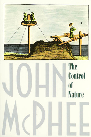
The Control of Nature – John McPhee

The Control of Nature

It is a discredit to my literary general knowledge that this is the first book I have read by American author John McPhee. He is a prolific and well regarded non-fiction author whose other work I will be hunting down post haste. The Control of Nature comprises three long essays, each detailing an attempt by man to modify and contain his natural environment. They read like engineering thrillers (which puts me in mind of my brother in law – maybe he needs this book in his life, too). McPhee explains complex engineering concepts in terms that anyone can grasp.

The first essay, entitled Atchafalayadeals with the Mississippi River, which is cannibalised by its distributary the Atchafalaya River in Louisiana, near its mouth. A complex structure called the Old River Control Structure determines how much of the Mississippi is allowed into the Atchafalaya. Left uncontrolled, the Mississippi would change course entirely, with dire economic and sociological consequences for New Orleans and surrounds. The history and workings of the Old River Control Structure alone are fascinating enough to sell the book – check out the Wikipedia entry for a taste of it.

The second essay describes the surprisingly successful attempts by Icelandic islanders from Heimaey to redirect a flow of volcanic lava that was threatening their fishing harbour (of major economic importance – notice a trend here) during an eruption of the volcano Eldfell in 1973. The task was Herculean. Islanders pumped seawater out onto the lava, and worked in conditions so steamy (from evaporating water) and hot that their boots melted and they couldn’t see more than a few metres in front of them. Part of the town was destroyed – preserved like Pompeii – but the size of the island was increased and the harbour is now better protected than it was before the eruption, thanks to lava outflows and rocks shielding it from the prevailing winds. Heimaey is beautiful – there’s a short article about the place here, with photos sourced from here.

 Finally, McPhee deals with Los Angeles, a city which seems ubiquitous in a certain type of news media, but for reasons entirely other than the ones McPhee writes about. It turns out that the San Gabriel mountains above Los Angeles have some striking similarities to the fynbos-covered slopes around Cape Town. The climate is also Mediterranean – hot, dry summers and wet winters. The vegetation in the San Gabriel mountains is called chaparral, and like fynbos it needs to burn every decade or so for germination of new plants and removal of the overstory of growth. Volatile oils in the leaves of these plants mean that they burn hot and fast, and sometimes gases released from the plants explode in the air as they burn. After a fire, the steep slopes are vulnerable to landslides, comprising rock, gravel and mud. Debris basins – essentially giant empty reservoirs – are built to collect the debris from these massively destructive floods before it reaches the expensive homes high in the mountains. When the debris does reach an area of human habitation, the effects are swift and disastrous.

All three the enterprises McPhee describes are (or were) very costly. Two of them – the government-led control of the Mississippi and of the Los Angeles mudslides – are ongoing and will always be as long as populations inhabit the areas concerned or wish to continue with commerce as it currently is. Iceland is in a volcanic region and it is entirely conceivable that another eruption may threaten property and economics of a region in the future, and that another attempt will be made to drive back a metres-thick flow of boiling magma. I was exhausted after reading this book, and wished that everyone could just down tools and go away. I was also amazed by the scale of the efforts that go on every day to make our world habitable, wherever we choose to set down roots. I wondered what sort of similar activities, frenetic attempts to subdue and hold back earth and water, happen around me that I am not aware of.

A New York Times review of the book can be found here.

 You can get a copy of the book here (South Africa) otherwise here or here. I also discovered that the New Yorker published lengthy extracts from this book – you can read them online. For all I know it may even be the whole thing!

Bookshelf: People of the Sturgeon

People of the Sturgeon – Kathleen Schmitt Kline et al

People of the Sturgeon

Sturgeon are perhaps best known for their eggs, which are expensively consumed as caviar. There are sturgeon populations in various locations in the northern hemisphere – perhaps the Russian sturgeon are the best known. A population is also found in Lake Winnebago in Wisconsin, which is the focus of this book.

Sturgeon fishing is a popular pastime in the area, where the fish are speared through holes in the ice during the winter months. People of the Sturgeon is a cultural history of the fish, describing its biology (the fish grow to great sizes and can live for over 100 years) but also placing it in the proper historical and cultural context. The Menominee Indians inhabiting the area attach great significance to the fish, consuming them on feast days and passing on fishing techniques from generation to generation.

A conservation organisation called Sturgeon for Tomorrow works specifically for the preservation of lake sturgeon in Wisconsin. It was formed by local spear fishermen who realised that they needed to act in order to ensure that there would still be a population of sturgeon to spear in future years. Spear fishing for sturgeon is well regulated, with strict opening hours, prohibition of the use of lights to attract fish, and fishing methods right down to the dimensions of the holes that may be cut in the lake’s ice. Residents do “sturgeon patrol” in order to prevent poaching of the fish out of season and in locations other than the designated fishing areas. Each sturgeon that is caught during the season is logged, which provides high quality data for management of the fishery.

Sturgeon for Tomorrow is a detailed look at a very small geographic area and the profound significance that its people attach to a remarkable fish. It is a reminder that conservation may not exist successfully without a cultural context, and how successful a conservation effort can be when it originates from and involves the community that uses the resource.

You can get a copy of the book here or here. The audiobook contains additional rich content including music and interviews with fishermen, craftsmen and others involved with sturgeon conservation. Here’s a documentary based on the book:

[youtube=”http://www.youtube.com/watch?v=Ue2x37e8rVg&w=540″]

Article: Nautilus on sea lamprey

Nautilus ran an article earlier this year about lampreys, fish that look like something out of the X Files. They are probably close relatives of hagfish; like hagfish, lampreys are jawless. They attach their round mouths to other fish and feed on their bodily fluids. They do not have a reputation as civilised dinner conversationalists.

While hagfish are marine animals, lampreys are anadromous: they return to fresh water (usually rivers) to spawn, in the same way that salmon do. When they’ve spawned, they die, fertilising the rivers and surrounding land with the nutrients from their bodies (in the same way as salmon do, but on a smaller scale).

Rehabilitation of North American rivers, along with the removal of dams, opens the way for fish such as salmon and alewives to return. Lampreys have returned too. Until recently they were viewed as invasive pests:

… the conventional American wisdom on sea lampreys was conceived following the late-19th- and early-20th-century collapse of world-renowned trout populations. The lampreys were invasive, having infiltrated the region through shipping canals; Great Lakes fish could not adapt to their ravages. Historical records describe the ease with which nets could be lowered to lake bottoms, then pulled back up with a cargo of sea lamprey-holed carcasses.

More recent research suggests that lampreys are native to at least Lake Ontario and several other lakes in the region, and were only able to colonise the rest of the Great Lakes when their native fish populations were all but destroyed by removing too many fish and modifying the ecosystem through damming, logging and agriculture.

Although they aren’t pretty, lampreys may be less of an invasive parasite and more of an essential participant in a balanced ecosystem than they were once thought to be. Read the Nautilus article here.

Friday photo: Silvermine river

Silvermine river mouth on Fish Hoek Beach

The Silvermine river drains onto Fish Hoek beach and into the sea, at the Clovelly end of the beach. Along its banks and nearby, pieces of metal from the wreck of the SS Kakapo (which is on Noordhoek beach) can be observed. You can see Tony’s drone hovering just above the river to the mid-left of the photo.

Scattered shipwreck: Hull plates of SS Kakapo at Clovelly

The wreck of the Kakapo on Long Beach, Noordhoek

The wreck of the SS Kakapo is one of the few shipwrecks around Cape Town that you don’t need a diving qualification to visit. It’s located on Long Beach, Noordhoek, and is a striking sight, high and dry on the sand.

For some reason I have never interrogated why so little of the hull, decks and superstructure of the Kakapo remain. Her boilers, ribs, and some other parts of her structural stick out of the sand, but there isn’t much else to distinguish her. Reading an issue of The Cape Odyssey, however, I was enlightened as to what happened to the rest of the ship… And I realised that Tony and I have probably walked past piece of the Kakapo more than once without realising it.

Railway line at Clovelly

After World War I, pieces of the Kakapo‘s hull were used to shore up the railway line as it crosses the Silvermine River at Clovelly. Also, in addition to 44 gallon drums filled with concrete, pieces of metal from the Kakapo were used to strengthen the river banks at the same location. A visit to the Clovelly end of Fish Hoek beach reveals not only expanses of rusty metal alongside the railway line, but also, emerging from the river banks near the bridge, other mysterious metal sheets mixed in with metal, concrete-filled drums.


Silvermine River on Clovelly beach

There’s a nifty, nearly one hundred year old bit of recycling for you!

Flying the drone at Glencairn

The Else river at Glencairn

We took the drone down to Glencairn Beach one evening so that I could stroll and enjoy the sunset, and Tony could fly a bit. The SA Agulhas (now a SAMSA training vessel) was in False Bay, seen near Roman Rock lighthouse. Tony hoped absently that it had run aground, thus supplying us with a new wreck to dive.

Roman Rock & SA Agulhas in the distance

There had been a bit of winter rain, so the Else River was in full flood. The waves on the beach were small and quiet. The sand seemed impossibly smooth and glossy. The colours of the sea and sky melted into one another near the horizon. It was one of those evenings that calms you down, regardless of how the day has been.

Here’s a little bit of Tony’s video from the evening:

[youtube=”http://www.youtube.com/watch?v=P8vaTYYJ8k0&w=540″]

Series: Saving the Ocean

Saving the Ocean with Carl Safina

I know Carl Safina as the author of several wonderful books about the ocean – The View from Lazy Point being the most recent one. I was surprised to discover that he has also ventured into television presenting, and this PBS series (so far a one-off) is the result.

Saving the Ocean showcases, in half hour segments, communities and initiatives that are successfully making a positive difference to ocean environments. Safina visits Baja in Mexico (grey whales are thriving there), Washington State (rivers are being rehabilitated there, for wild salmon), and Trinidad (where leatherback turtles are being protected). An episode where the leaders of the Muslim community on a Tanzanian island are taking the lead in advocating for environmental protection was particularly moving. Tony and I both found it immensely encouraging, and relieving, to see places where a balance is being struck between human requirements – for fish, protein, survival – and the need to take care of the sea.

A few times I felt that an excessive amount of enthusiasm was being displayed for a recovery that isn’t that spectacular – particularly in the episodes on New England cod. After hours of fishing, two or three tiny fish are caught. This in an area where you could lower a bucket and raise it up full of fish a couple of hundred years ago. The cod are still gone – no matter how much you smile about it.

Safina is an enthusiastic fisherman, and devotes two episodes to an artisanal sword fishery on Georges Bank. The fishermen harpoon the swordfish, collecting no bycatch. While I understand that this is a good way in which to target the species, I wasn’t convinced that there were enough swordfish to justify catching them at all, and I think the thrill of the hunt got in the way of telling the real story here.

The final episode in the series is about lionfish, and describes some of the innovative ways that the dive industry in the Atlantic is helping to control numbers of this native Pacific interloper.

Safina is an engaging host, refreshingly natural, like a slightly rumpled professor of an outdoorsy subject. The production values in this series aren’t fantastic, but this is made up for by the sheer good news of the stories told in each episode.

You can get the DVDs here if you’re in South Africa, otherwise here or here. Read a bit more about the show here, if you’re not convinced.

Bookshelf: Dark Descent

Dark Descent – Kevin F. McMurray

Dark Descent
Dark Descent

Kevin McMurray is the author of Deep Descent, a riveting account of diving the wreck of the Andrea Doria. Here, he turns his attention to the largely forgotten wreck of the RMS Empress of Irelanda liner that sank in Canada’s St Lawrence River in 1914, after colliding with a Norwegian vessel in thick fog. Over 1,000 people lost their lives. The Empress lies in just over forty metres of water, but the current, cold water, low visibility and lack of ambient light make it an extremely challenging dive site on which several divers have lost their lives.

McMurray provides a detailed account of the collision, sinking, and subsequent enquiries into the accident. He also describes the history of diving endeavours on the vessel, which began in 1964, when diving equipment was considerably more rudimentary than it is today. As with the Andrea Doria, it is possible to penetrate the Empress of Ireland through the collision hole in her side. The wreck lies partially on her side, which makes the interior disorienting.

The author has dived the wreck several times himself, which enables him to speak authoritatively of the challenges of cold water, low visibility diving (much like what we sometimes do in Cape Town). The wreck lies some distance out in the river (the St Lawrence is wide and eminently navigable) which has its own associated challenges, too.

There has been a fair amount of political wrangling over the wreck, perpetrated by rival dive charters, self-appointed guardians of the wreck site, and others who hoped to benefit materially from the wreck, and McMurray details some of this.

I found McMurray’s account of diving the Andrea Doria to be more immediate (and to give me more nightmares) than Dark Descent, but it is nonetheless an extremely interesting book that itself serves as a monument to what is Canada’s worst peacetime disaster. Both McMurray’s books go some way to explaining the allure of challenging wreck dives that only few divers will ever have the chance to visit.

You can get a copy of the book here or here.