The weekend forecast looks really spectacular… If you are a surfer. A nice six metre swell rolls in on a 15 second period, meaning the big wave surfers are busy waxing their boards as we speak.
I think that Friday, Saturday and Sunday should offer a few really good photo opportunities at Dungeons as well as Sunset Reef. The wind will be a factor so I will most likely launch on Friday and Sunday. Let me know if you want to hitch a ride.
Last week we met Smith’s swimming crab (Charybdis smithii), a rare visitor from the tropics that arrived in the southern reaches of False Bay during the third week of January 2019. We found some adult individuals at Long Beach, well inside False Bay, on 3 March.
Juvenile Smith’s swimming crabs at Kommetjie
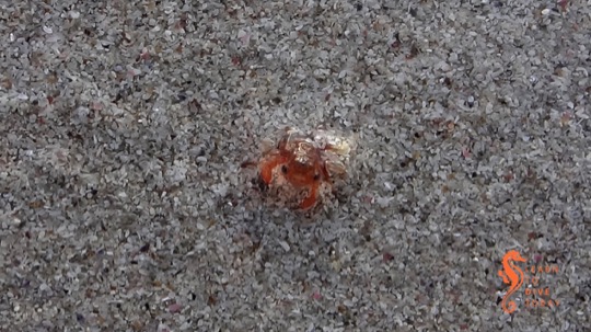
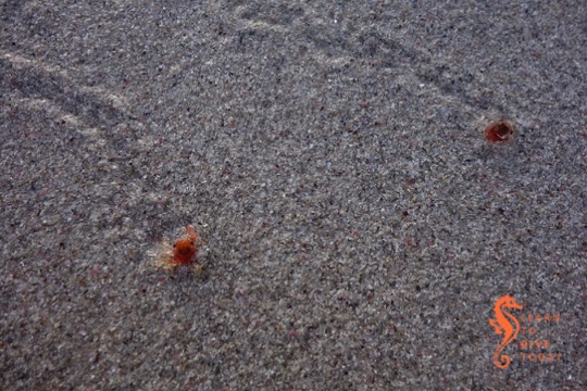
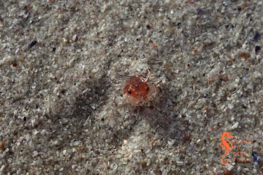
At the same time that fishermen were reporting adult Smith’s swimming crab off Cape Point, a huge number of tiny red crabs washed up on Long Beach, Kommetjie. There were great piles of them, but we only managed to visit a day or two later on Friday 18 January.
Juvenile Smith’s swimming crab at Kommetjie
We had to hunt a little, but after a while we found the crabs – now only a few remaining, but most of them very active and vital. Opinion from George Branch is that these are most likely the final larval stage of Smith’s swimming crab, and the same warm conditions wit anomalous westerlies that brought their adults to the peninsula, brought the juveniles.
Juvenile Smith’s swimming crab at Kommetjie
This conversation (facebook group, may be closed) suggests that the juvenile Smith’s swimming crabs were also seen on Milnerton Beach around the same time as they appeared on the beach at Kommetjie.
I took a couple of short videos of the tiny crabs, which show them in motion on the wet sand.
Apologies for the loud wave noise and less than perfectly steady camera work. Read more about these pelagic crabs, exceptionally infrequent visitors to our shores, in this post.
No diving
This weekend we are hamstrung by the Cape Town Cycle Tour on Sunday – good luck if you are participating! I’m away in Port Elizabeth on Saturday, so I won’t be running dives even if it wasn’t going to be rather windy (it is).
I’ll be diving with students during next week, so let me know if you want to tag along and I’ll keep you posted.
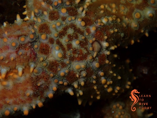
Sea star at Long Beach
Ocean/Surf night at the Cape Town Adventure Film Festival
Film buff? Love the ocean? Think popcorn is a food group? This event on Friday, 12 April, may be right up your street. Get tickets here.
regards
Tony Lindeque
076 817 1099
www.learntodivetoday.co.zawww.learntodivetoday.co.za/blog/Diving is addictive!
To subscribe to receive this newsletter by email, use the form on this page!
There are large patches of red tide in False Bay, and no wind to clear them up. For this reason I’ll decide on Saturday whether we’ll be boat or shore diving on Sunday. I have students, so we’ll keep it relatively shallow either way. Let me know if you want to keep in the loop for the weekend dives. There’s been bioluminescence at the Strand beach this week, so keep an eye out for it around Fish Hoek beach during the evenings if the red tide persists.
Spring high tide at Fish Hoek beach
Tidal documentary
Don’t forget the screening of Tidal at St James beach on Thursday 7 March. RSVP here.
Using the 26 hours of voice recordings recovered from the ship’s deep water resting place after a prolonged search, Rachel Slade is able to reconstruct, in detail, the final voyage of El Faro. Slade also attended the hearings on the sinking held by the US Coast Guard, and interviewed the family and friends of El Faro‘s crew. The result is a detailed and illuminating investigative work that explains the disaster more comprehensively than simply to say that the ship sailed into a hurricane and sank. Slade also emphasises the humanity, connections and personalities of the captain and crew, who otherwise might be lost in the telling as statistics of loss.
The official explanations, and absence of any assumption of culpability for the tragedy, are enraging and frustrating, but illustrate the insidious pressure to take risks that commercial mariners may experience from ship owners and operators. This dynamic plays out at all scales. Even as a small business owner, Tony is sometimes asked to launch his boat in conditions that he deems unsafe. A client may put their own financial gain ahead of the safety of the divers, or of my husband. The risk of such a venture is entirely with the captain and others on the vessel, while the decision-maker (and financial beneficiary of the decision) sits ashore in safety like General Melchett sending his troops to their doom.
Slade’s book is a gripping read, accurately and comprehensively reported, and will appeal to anyone with an interest in maritime drama. It is also of particular interest given that warming oceans will give rise to more storms like Jaoquin, and our ability to forecast their movements with accuracy will, to an increasing degree, impact captains’ ability to keep themselves, their crew and their cargo out of harm’s way.
Do not confuse this book with Into a Raging Sea, the excellent book about South Africa’s National Sea Rescue Institute.
Get Into The Raging Sea here (US), here (UK) or here (South Africa).
No diving This weekend’s wind is forecast to be between 30 and 50 km/h, which, in my book, renders the weekend not suitable for diving. Sorry, kids.
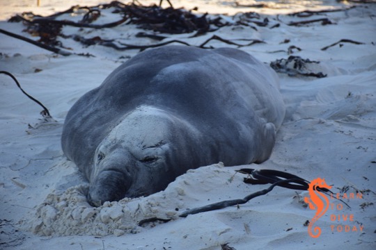
Elephant seal on Fish Hoek beach
See a seal instead
If you feel like a natural exfoliation, the visiting elephant seal is still on Fish Hoek beach, just after the little yellow and white mini lighthouse half way down the beach. He’ll be leaving soonish, so don’t delay. Read more about elephant seals here.
One of the most spectacular shipwrecks I’ve ever seen was that of the 100 metre long unmanned barge Margaret, which ran aground at Jacobsbaai on the West Coast on 24 June 2009. Margaret was carrying two halves of a floating dry dock and twelve river barges (positioned atop each other in side by side pairs, with two rows of three at the bottom). She was under tow by the tug Salvaliant from the Chinese shipyard where everything was manufactured, to Rotterdam. The barges were destined to transport cargo up and down the navigable rivers in Europe. During a winter storm, the tow parted, and Margaret and her cargo ran hard aground on the rocky reef just outside Jacobsbaai.
The eight storey pile of barges in December 2009
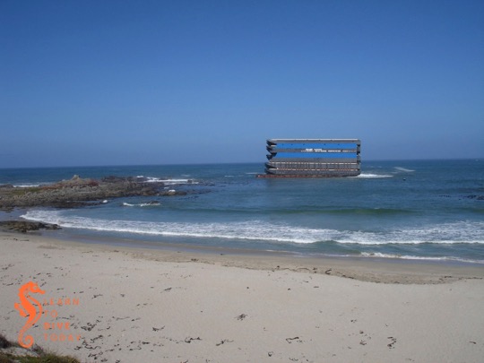
Salvaging the barges proved to be an almost intractable problem, so Margaret was still sitting firmly a couple of hundred metres off the beach when Tony and I visited six months after her grounding, in late December 2009. The stack of barges and two halves of a floating dry dock (the blue parts of the structure in the images) was clearly visible from a great distance. The sight was even more incongruous than that of the Eihatsu Maru aground on Clifton beach, which was a wreck-lover’s dream (but unfortunately not a permanent arrangement).
View of the barge Margaret from atop the sand dunes at Jacobsbaai
I wish I’d taken a picture of what the wreck looked like as we drove down the hill into Jacobsbaai, but you can see one here if you scroll around a bit. It looked like an office block rising out of the ocean. The wreck was so large that it was visible from almost every point in the sleepy town, and the brain struggled to make sense of the sight. It’s clear from the images what a challenge it must have been to tow the barge in the wind, as the forty to fifty metre high, perfectly flat sides of the stack must have provided tremendous resistance in a gale.
Portion of the barge wreck at Jacobsbaai
The owner ran out of money to continue salvage in February 2010, and Margaret was becoming increasingly damaged and unstable as time passed. The risk of the upper barges coming loose during another storm, and drifting away to cause a hazard to other ships or coming ashore on the beach, was great. It was decided by SAMSA to persist with an attempt to reduce the wreck, at taxpayers’ expense. Any money obtained by selling off the salvageable barges would go towards defraying costs.
During the salvage work on the barge Margaret
Salvage
Tony and I visited the wreck again in April 2010, after the demolition that freed six of the topmost barges. The seaward wall of the upper piece of floating dry dock, weighing 91 tonnes, had been cut away to allow the barges to slide off freely.
The remains of the barge Margaret in April 2010
Over two tons of explosives were used in total. Small (125 kilogram) explosive charges were set off one after the other to create a ripple effect that dislodged the top six barges. These were towed to Saldanha, and then sold.
The wreckage of Margaret and her cargo in April 2010
If you like reading court judgments, here’s one in which the owners of the barges attempt to claim damages (massive ones) from the owners of the tug Salvaliant. There’s also a great collection of photos of the wreck in her various incarnations here.
The wreckage of Margaret in late April 2010
In late April 2012, Tony snapped this lucky shot of two of the barges leaving Simons Town harbour under tow. They’d been moored against the harbour wall for at least a month, to the consternation and fascination of the local paddling community.
Two of the salvaged barges leaving Simons Town harbour in April 2012
The remains of Margaret and her cargo were further demolished down to sea level and below, and now comprise an artificial reef. Fortunately there was no fuel or other pollutants in the stack of barges, which made the process significantly less polluting than it might otherwise have been.
The barge Margaret today
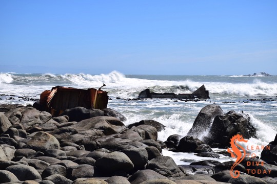
Tony and I visited Jacobsbaai to check out what remains of Margaret and her cargo in September 2018. The path to the wreck, which was formerly blocked off by hazard tape and “salvage in progress” signs, is wide and easily walkable. One can go right up to the rocks and view the wreckage from reasonably close up. Watch your foothold here, as it can be slippery and the rocks aren’t all firmly packed.
The remains of the barge Margaret and her cargo
Look out for a small memorial to one of the salvors, who passed away in an accident on the wreck during the course of the salvage operation.
Sharp wreckage sticking out of the sea
Parts of the wreck look like shark fins in the water, and it is possible that even more of it is visible at low tide.
The remains of the barge Margaret in 2018
You can find the wreck by turning off the R399 towards Jacobsbaai, and continuing towards the coast until the road becomes gravel. Carry on this road, and when you reach a T junction take a right turn to circle around the tiny, sheltered bay in front of you. When you can’t drive any more – there will be a small housing development in front of you – park the car and either walk up the steps on the dune to get onto the beach, or, preferably, through the houses. The paved area will give way to a wide gravel path that the salvors used to access the wreck. Continue straight along it and you’ll soon spot the wreckage on the rocks ahead and to your right. Co-ordinates are approximately -32.964140, 17.881612.
The Cape Columbine Nature Reserve is just outside the small fishing town of Paternoster on the West Coast. It’s the reserve that contains Tietiesbaai campsite, and is a popular camping location during crayfishing season. Tony and I camped there several years ago, and enjoyed the space and the ability to set up anywhere we wanted to.
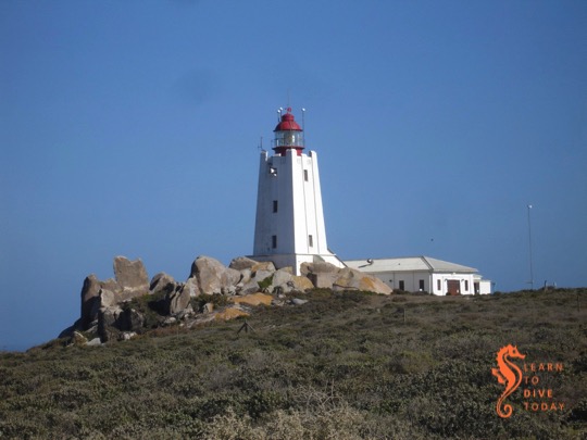
Cape Columbine lighthouse
Inside the reserve is the Cape Columbine lighthouse, which has an art deco feel to it. Built on top of a rocky outcrop called Castle Rock, it was commissioned in 1936. The lighthouse is a 15 metre high masonry tower topped by a 5,040,000 candela light with a range of 30 nautical miles. It covers a particularly treacherous coast, prone to fog and gales, and with many hidden reefs.
Cape Columbine lighthouse
Cape Columbine lighthouse is manned, and can be visited by the public on weekdays between 10.00 and 15.00.Cape Columbine was the last manned lighthouse to be constructed in South Africa. We haven’t passed by on a weekday yet, so I haven’t been inside.
As of late 2018, the Cape Columbine lighthouse needs a coat of paint!
When we camped at Columbine Nature Reserve in 2009, the lighthouse was in much better shape. I took the picture below on that trip. If you drive around the lighthouse, you may see a small green tower inside a fenced off area that houses a fog detector, and a fog signal that sounds when fog is detected. This apparatus used to be housed at the lighthouse, but in 1995 the opportunity was taken to move both sets of devices (detector and signaller) closer to the sea.
No diving The forecasts vary wildly this weekend. Windy says howling south easter everywhere, whilst other sites say mild wind suitable for some Atlantic diving. The mountain will break some of the wind so I am sure Table Bay sites will be good, and Hout Bay much the same. I have students for the pool this weekend so there are no launches planned.
Clare is selling her Sony underwater housing that fits the Sony RX100 range of cameras. If you’re interested, drop me a mail and I’ll put you in touch with her.
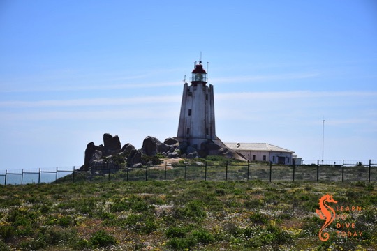
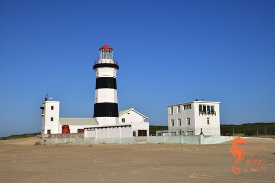
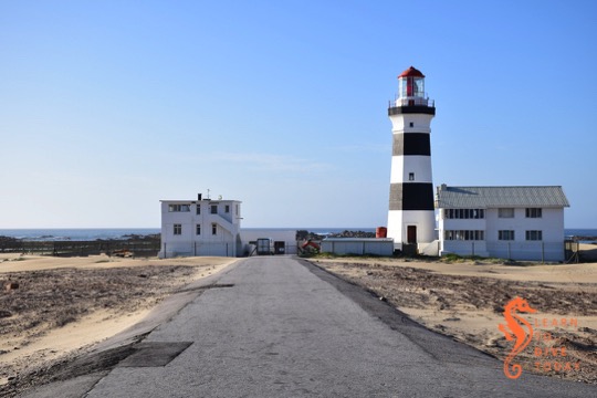
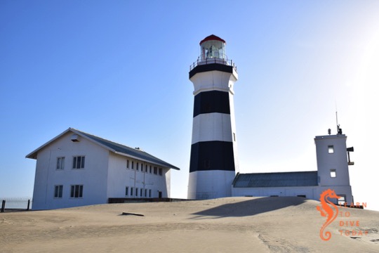
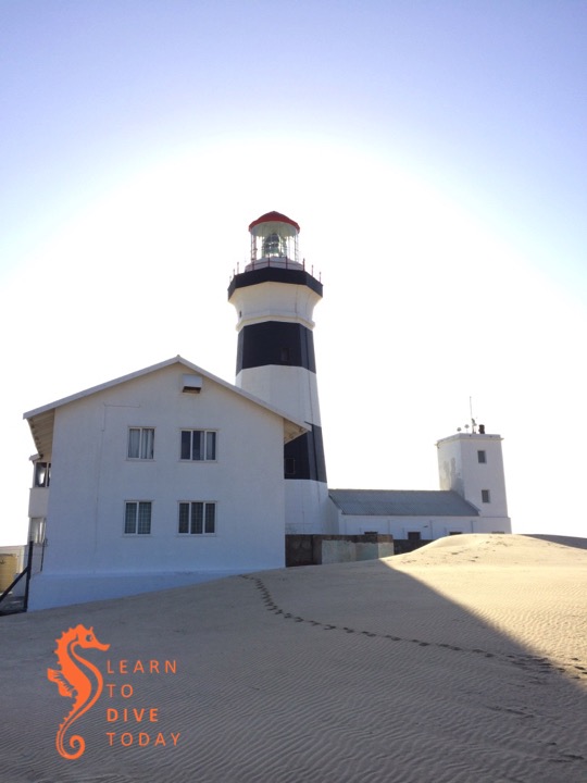
My favourite lighthouse in Port Elizabeth (the others are the Hill lighthouse and the Deal light) – and possibly anywhere in South Africa – is Cape Recife. It’s magnificently situated on a headland at the south end of Algoa Bay, surrounded by shifting sand dunes (which sometimes complicate road access after high winds) and rocky reefs. I visited it very early one morning, with only fishermen about.
Cape Recife lighthouse
Cape Recife lighthouse was commissioned in 1851, the fourth lighthouse to be commissioned in South Africa. Of those still operational, it is the third oldest (after Green Point and Cape Agulhas). It comprises an octagonal masonry tower. It was originally painted with bands of white and red; today (as you can see from the eleventy million pictures I took) it’s painted black and white. This change was made in 1929.
Cape Recife lighthouse
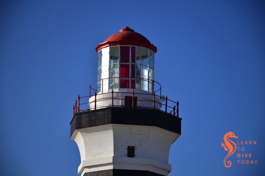
The tower is 24 metres high, with focal plane 28 metres above sea level. The light’s intensity is 4,000,000 candelas (compare the Deal light’s 592,000 candelas) and is visible from 29 nautical miles away.
Lantern house of Cape Recife lighthouse
The Cape Recife light has the only large lens in South Africa that rotates on a steel track, resting on brass and steel rollers. The other large lenses (for example at Slangkop) float on a bath of mercury, an arrangement which has the advantage of being virtually frictionless. This allows for much faster and smoother rotation, with no wear and tear on the component parts. Unfortunately frequent exposure to mercury entails serious health hazards.
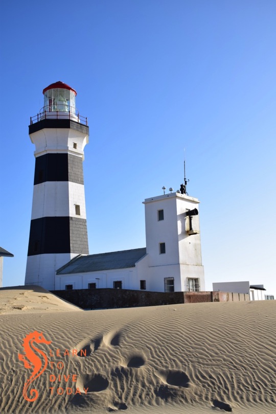
Tower of Cape Recife lighthouse
The lighthouse is situated next to the Cape Recife nature reserve, which has excellent bird watching. A small fee to enter the area is required – permits obtainable at Pine Lodge Resort (or possibly at the gate). Check before visiting. No diving is allowed in the area, and you will be fined if you are found with dive gear in your vehicle. SANCCOB (formerly SAMREC) runs a seabird rescue centre on the way to the lighthouse. If you visit SANCCOB, and get your entry ticket stamped to prove it, the permit fee is waived.
Cape Recife lighthouse
It’s possible to go inside the lighthouse on weekdays, by calling ahead to make an appointment. The number on the sign outside was (041) 507 2484. If dialling from outside South Africa, replace the (041) with +27 41.
Footsteps on the sand outside Cape Recife lighthouse
Lighthouses of South Africa has a lot more information about this gorgeous lighthouse, along with extensive pictures of its interior.