Both Saturday and Sunday have a fair bit of wind and a fair sized swell. It is unlikely that I will dive as this typically makes the surface conditions very unpleasant. Things do however change and should the forecast change much tomorrow I will plan some diving. Let me know if you want to get on the hopeful list!
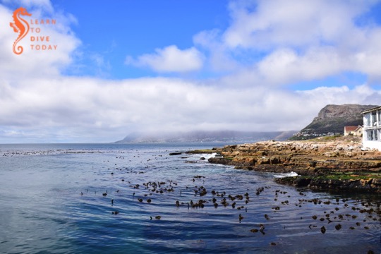
The beach at Millers Point
Water
This week’s Wednesday Water File from the WWF is about business continuity. Read it here, and enjoy the rain tomorrow!
I reckon the better option for diving this weekend will be on Sunday morning in False Bay. The tide is against us but I still think the visibility will be better than in the Atlantic. We will meet in the False Bay Yacht Club parking lot at 8.30 am with the aim of launching by 9.00 am. It will be a double tanker (that means your options are two dives, or none) as the wind speed grows by lunchtime. Let me know if you’re keen to come along.
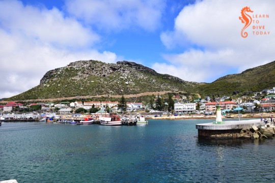
Sunny Kalk Bay
Water
The latest Wednesday Water File from the WWF is about the power of community. Read it here. On that subject, here’s something on starting a water committee (at your apartment block, office, or kids’ school, for example). Community could be the eleventh good thing about the drought, if one were to extend this excellent list from WESSA.
The south easterlies are not ready to leave yet for the winter, but they are giving us a break right now. The forecast is for strong westerly wind tomorrow which will, if it blows, clean up False Bay rather nicely for some good visibility on Saturday. There is a 3 metre swell arriving on Saturday but I think it will be fine for a dive or two, and the tides are in our favour.
We will meet at the False Bay Yacht Club Parking at 9.00am. We’ll double tank it and choose the sites once we’re out there. Let me know if you want to be on board.
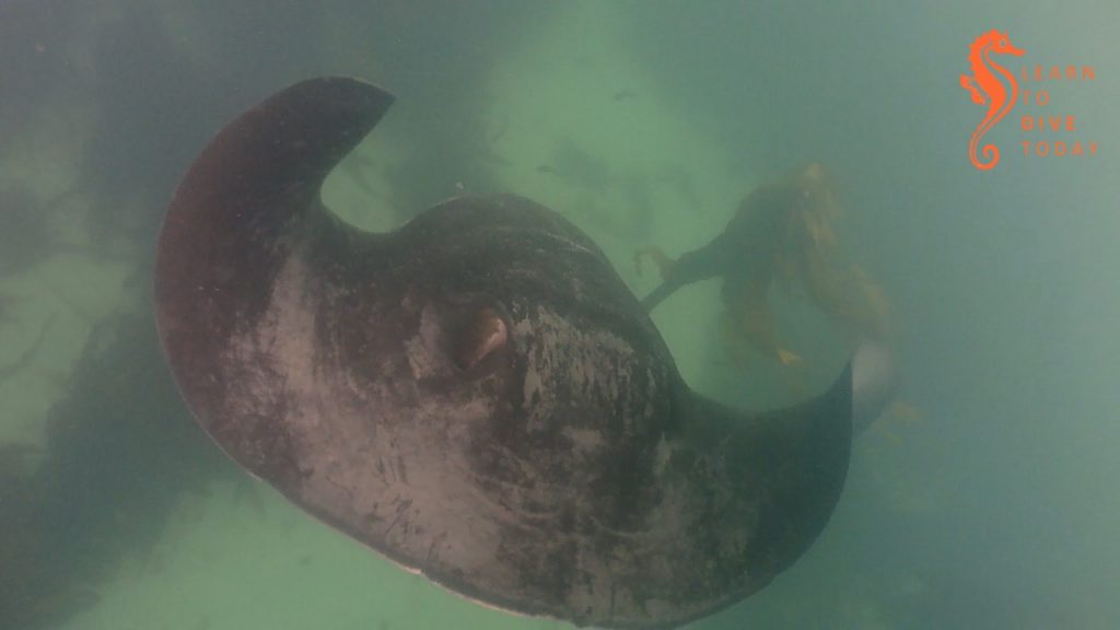
Giant short tailed stingray at Millers Point
I had a couple of good days on the boat this week, the highlight being watching this huge giant short tailed stingray on a flat calm day.
Water
We shared a blog post about diving during a drought this week. Check it out! Also, the WWF’s fourth Wednesday Water File was published yesterday, and it’s very pertinent. It’s all about toilets. Read it here.
Currently abundant fresh water and good diving conditions every weekend are at the top of my wish list. Both Saturday and Sunday will sport 30+ km/h winds, from the south east. There is a slim chance that Hout Bay could have cleaned up by Sunday, however the 3 metre swell will make for sloppy surface conditions. Should Sunday look better by late Saturday, I will get in touch with those on the list… So get on the list (email, whatsapp, text, phonecall, or post office tree can work).
Water
Read the WWF’s third Wednesday Water File (all about securing fresh drinking water) here. We’ll be sharing some tips about diving during a drought, and preparing for Day Zero, on the blog in the coming weeks.
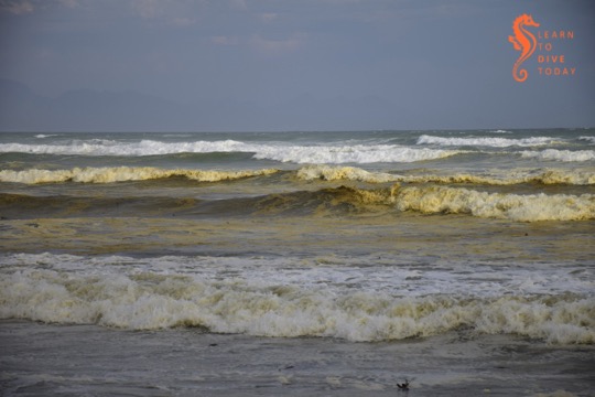
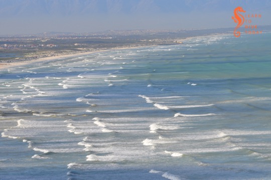
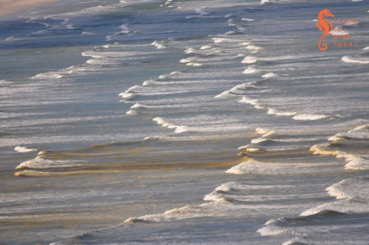
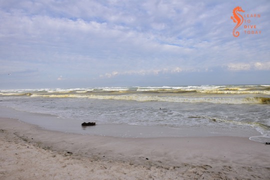
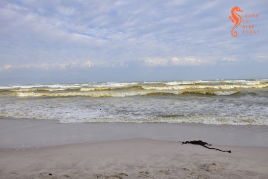
Capetonians are familiar with the tea-coloured water that runs in our mountain streams. Most people know that the brown colour comes from tannins, leached naturally from the indigenous fynbos vegetation. Perhaps less well known is the reason for the brown water that is sometimes seen in the surf zone along Muizenberg beach, stretching all the way to Strandfontein, Monwabisi and beyond.
Tea-coloured water at Muizenberg
The most frequent explanations that are offered on social media are, of course, pollution, “raw sewage”, and the like. This is not the reason for the brown water, and it does not necessarily impact the water’s safety or healthfulness for humans to swim in.
Like False Bay’s famous colour fronts, the reason for the brown waves at Muizenberg beach turns out to have much to do with the topography of False Bay, particularly of the kilometres-long beach at its head (Muizenberg-Strandfontein-Macassar-Monwabisi), and something called a diatom.
View of Muizenberg showing patches of brown water
Diatoms
Diatoms are a type of phytoplankton (plant plankton or microalgae). They are single celled, usually symmetrically shaped organisms that multiply by dividing in half at a constant rate. Their cell walls are made of silica, SiO2. Chicken keepers and gardeners may be familiar with diatomaceous earth – this is made up of the fossilised shells of ancient diatoms.
Diatoms are what are called primary producers or autotrophs, meaning that they generate organic material from carbon dioxide and other inorganic nutrients (for example nitrates and phosphates), through the process of photosynthesis, which uses light as an energy source. Primary producers sit at the base of the food chain and all life relies on them, directly or indirectly. Everything else produces organic material from other organic material (such as diatoms).
I am telling you all about diatoms because the brown water at Muizenberg contains an accumulation of a diatom that you can call Anaulus australis Drebes et Schultz the first time you mention it, but usually just Anaulus australis, or Anaulus for short. There are several members of the genus Anaulus, but usually just one tends to be dominant at each beach where these accumulations occur, and Anaulus australis is the main species found along the South African coast.
Analaus are pillow-shaped diatoms. If you wanted to see what an individual Anaulus diatom looked like, you’d use a microscope, but when enough of them are in one place, they can be seen to change the colour of the water. There’s a picture of them under a microscope at the bottom of this webpage (they also occur in Brazil). They occur at beaches with particular topograhical characteristics, which explains why you haven’t seen them at Camps Bay, Kogel Bay, or Scarborough.
At hospitable beaches, the diatoms are always there, spending much of the time lying dormant in the sand behind the surf zone. A proportion of the diatom population is able to survive for relatively long periods (estimated to be more than two months) like this, in the dark on the seabed, not photosynthesising or dividing, until the correct meteorological conditions arise for an accumulation. But first – what sorts of beaches are hospitable to Anaulus?
a nutrient source close to the surf zone (often an unconfined aquifer overlaid by a dune field)
Muizenberg and Strandfontein beach tick all these boxes. The beach stretches from Surfers Corner all the way across the top of False Bay to Monwabisi, a distance of over 20 kilometres. It is a high energy beach, meaning that it is exposed to large waves and strong winds, and is not protected by any offshore features such as sandbars or headlands that might reduce the force of the waves. Rip currents do occur at the beach, and both these and the exceptionally wide surf zone – wider during south easterly winds in summer – can be observed from the mountainside on Boyes Drive. (A rip current is like a hidden river flowing out to sea from the beach. The Sydney Morning Herald has an excellent visual explainer of rip currents here.)
The head of False Bay where Muizenberg is situated is incredibly nutrient-rich, much of it thanks to urbanisation. The canalised Zandvlei estuary – the only vaguely functional one on False Bay’s coast – is situated a short distance down the beach, and supplies nitrates, phosphates and other nutrients to the surf zone. Many of these nutrients are technically pollutants, added to the river further upstream. The Cape Flats Waste Water Treatment plant at Strandfontein also discharges 200 million litres of treated water per day (under normal, non-drought circumstances) via a canal onto Strandfontein beach. This is essentially an artificial estuary for Zeekoevlei. This waste water has spent some time working its way through the settlement ponds at Strandfontein, but is nevertheless rich in ammonia and other nutrients, and Anaulus accumulations are a very common sight in the surf around this discharge point. The dunes that run along Baden Powell drive overlay a high water table, and groundwater seepage – specially during times of heavy rainfall – may also leach nutrients out of the ground and into the surf zone.
Meteorological conditions
The meteorological conditions required for an Anaulus accumulation involve strong wind and a large swell. These act together to create rough sea conditions, which stir up the dormant diatoms from the ocean floor. The diatoms adhere to air bubbles in the surf zone, staying suspended in the water column, which is when you would notice the water turning brown. Exposed to light, they awaken from their dormant state and start to photosynthesise, take up nutrients, divide and multiply. The presence of rip currents creates an onshore-offshore flow all along the beach. This forms a semi-closed ecosystem, and the diatoms are essentially trapped in gyres in the waves. Longshore currents that run parallel to the beach transport Anaulus cells out of the surf zone at one end, and bring fresh (sea)water in at the other end of the beach.
It may seem surprising that anything manages to accumulate in the waves of a beach, but the surf zone is actually quite retentive, meaning that things that end up there often tend to stay there. (Incidentally, this is why it’s a terrible idea to discharge the byproduct of reverse osmosis seawater desalination – a super-salty brine – into the surf zone. It must be discharged offshore so that it can disperse and mix with the surrounding water.)
Diatoms in the surf zone at Muizenberg
You’ll notice that, contrary to what you may have seen when large amounts of plankton are under discussion, I’ve been using the word “accumulation” instead of “bloom” to talk about Anaulus. This is deliberate, because of the constant presence and constant rate of division of the diatoms. When the water goes brown, it doesn’t mean that Anaulus is suddenly multiplying faster than usual. It means that it’s all been gathered together in patches, is exposed to light and therefore photosynthesising (at its usual steady rate), and is thus more visible than it was when it was lying on the ocean floor.
Anaulus at Muizenberg in November 2017
The human factor
You may also be thinking that everything I’ve said about the nutrients that Anaulus requires to survive and thrive points to the fact that humans – and pollution – are ultimately responsible for these brown-water plankton accumulations at Muizenberg. Well yes, in a way. But accumulations of Anaulus australis and related species have been observed and documented for well over 100 years at suitable beaches around the world, and are a natural phenomenon.
Yes, we are providing more nutrients to the False Bay diatom population than they would otherwise have received without human settlement in the greater Cape Town area, but these accumulations would likely occur regardless. They are certainly more intense now than they would have been in the past, but estuaries are nutrient-rich locations even when not surrounded by a large city. Furthermore, the water table is high on the Cape Flats, which would supply nutrients to the surf zone regardless of whether humans lived nearby.
Anaulus is in fact performing a vital and useful function by mopping up the excess nutrients that the city discharges in the ocean. The mass of diatoms – primary producers – also provides a food source to bivalves such as mussels, and other invertebrates. We can be grateful that the excess nutrients that urbanisation directs towards the ocean at the head of False Bay leads only to accumulations of harmless diatoms, rather than to frequent occurrences of harmful algal blooms that can kill marine life and exacerbate respiratory problems in humans.
Muizenberg during a diatom aggregation
Sources
Most of the original scientific study on surf zone diatoms in South Africa was done by a group of researchers (primarily M Talbot, Eileen Campbell and Guy Bate) from the University of Port Elizabeth, working at the Sundays River Beach in the Eastern Cape. I did quite a bit of reading to research this post, but you can start with this paper for a description of the topographical characteristics of beaches where surf zone diatoms accumulate. The first few chapters of this Masters thesis also provide a good overall survey of what is known about surf zone diatoms.
Putting knowledge into practice
Not every instance of brown, foamy water at the beach will be an Anaulus accumulation. On the west coast of South Africa, for example, there are no beaches where Anaulus occurs, but you may see brownish foam that is the result of heavy wave action frothing up organic matter in the surf (nothing sinister – there is a lot of organic material in the ocean). A clue to help you distinguish diatom accumulations from other brown-water phenomena – apart from running through the checklist of required beach characteristics above – is that an Anaulus accumulation doesn’t stretch much beyond the back of the surf zone. If the brown water stretches beyond the furthest row of waves, it’s probably something else. (And this seems like an apposite time to remind you that sewage looks whitish-grey, not brown, when it’s pumped out into the ocean.)
The number of beaches worldwide where surf zone diatom accumulations occur is so small – less than 100 – that Odebrecht et al could enumerate them in a 2013 paper. I hope this helps to convince you that the brown water at Muizenberg beach (and beyond) is something special and interesting, not to be feared. Go surfing!
Sunday: Atlantic ocean boat dives at 8.30 and 11.30 am
I completed an SDI Open Water course with students this week, and we dived Long Beach on two days. The visibility was 3-4 metres on both days, and later in the week it was extremely surgy.
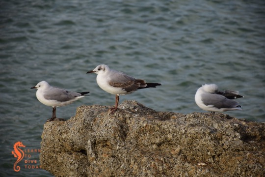
Roosting on the catwalk at Fish Hoek
It does appear that the Atlantic dive sites will be the ones to visit this weekend. False Bay is not great right now and the south easter won’t help, however it is exactly that strong south easterly wind that is needed to clean up the Atlantic. The south easter has been blowing for much of the day today, and is forecast to continue tomorrow and Saturday.
It really needs to be south easterly wind and not a southerly wind, and most important it needs to be blowing in Hout Bay. Strong wind in the northern suburbs, or over False Bay, doesn’t always translate into the same over Hout Bay. It drops off for Sunday, so clean cold water should be the order of the day. We will be launching from OPBC or Hout Bay (so we can check out the desalination plant) at 8.30 am and 11.00 am.
Water
Here’s this week’s Wednesday Water File from the WWF. It’s all about groundwater, and you should read it. If you’re feeling stressed and helpless about Day Zero, remember that we’ve been given the gift of a bit of time to prepare for it – and, just maybe, avert it (by using a hashtag, apparently) – so make a to do list, ask someone sensible for advice if you need it, don’t get scammed by a dodgy rainwater tank supplier, and get going.
The wind, strong as it has been, has not been from the right direction to create favourable diving conditions. The Atlantic needs good solid south easterly winds and there has not been enough of that yet. Tomorrow and Saturday are forecast to offer up wind from the right direction, but a 3.5 metre southerly swell will make for bumpy conditions even if the water cleans up.
This leaves us with False Bay. The swell direction is not one that is kind to False Bay so I think I will skip boat launches and plan shore dives at sheltered Long Beach on Sunday.
I will also be shore diving with students on Monday and Tuesday. Fun divers are welcome to join us as long as you’re happy to let me focus on my students. If you’re keen to get wet, let me know.
Hobie cat at Fish Hoek beach
Water
I trust that all of you are doing your very very best to save water and that you are thinking about and making plans for Day Zero, which seems more likely than not by this point. The WWF has started a helpful weekly publication to assist everyone through this period – read the first one here (pdf).
We have had more diving days this summer than is usual, and 2018 has started well with pretty good conditions and warm water… There have also been a few darker days. On Monday we were in Smitswinkel Bay with 1 metre visibility, but it looks good for the weekend. We had 19 degree water with 5 metre visibility at Ark Rock today, and I hope for the same thing tomorrow.
Saturday will be a bit windy, so we will plan for Sunday in False Bay. The most likely sites will be Roman Rock and Shark Alley, I would like to see a bit more of the sevengills after their long vacation. If you want to dive, let me know.
As per normal for this time of year, most people are on vacation and on most days, diving is ruled out by the conditions. Despite my hopes of more diving than during a regular week, the rest of this week and weekend don’t look all that rosy.
View of False Bay from Red Hill in the wind
The Atlantic is patchy, False Bay is brownish-green… So wait we must. I think that Sunday will be a decent day for launching out of Hout Bay, and Monday, late morning, will be better in False Bay. Give me a shout if you want to be on the list.
Just in time for Christmas, we have been granted a few days of almost flat seas and very little wind. To top it off the wind direction is also great for False Bay. Friday, Saturday and Sunday all look like good days for False Bay.
I am keen to launch in False Bay tomorrow, Saturday and Sunday so if diving is in your plans for the next day let me know as soon as possible and I’ll keep you informed of the schedule.
We were at Tafelberg Reef today, then the wreck of the Maori, and then Duiker Island. Although (or rather, because) the visibility was good, the water was cold…. Seven degrees below the thermocline. We had the wind change direction at midday and by late afternoon Hout Bay was starting to darken so I doubt the Atlantic visibility will hold for too long.
This will be the last newsletter before Christmas so I would like to wish those of you that celebrate it a good one, and to everyone without exception a safe and happy time with family over the upcoming crop of public holidays and (hopefully) time off from work.