We have south easterly winds of between 30 and 60 km/h spread out over the next few days, and as a result I am not planning any dives for this weekend.
SAS Somerset at the V&A Waterfront
Diver24
Join UCT Underwater Club and the Two Oceans Aquarium for their annual Diver24 event. This year you can enjoy diving-related talks, snacks, and the vibe of the aquarium at night. More info here (facebook).
On your way, you can check out SAS Somerset, pictured above, as she lists slightly in her berth behind the aquarium. She’s the sister ship of SAS Fleur, a deep dive not too far from Seal Island in False Bay.
Sunday: Shore dives from Long Beach in Simons Town
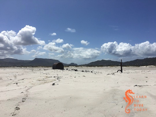
The Kakapo on Long Beach, Kommetjie
Thanks to the south easter, the Atlantic is getting cleaner. Hout Bay is still a little grubby, but there are two days of strong south easterly wind to fix it before Sunday. The temperature is already down to 12 degrees.
Sunday will most likely be the best bet for dives, out of Hout Bay or Granger Bay. The swell, however, is bigger that my boat likes, so we will shore dive in Simons Town on Sunday instead. Let me know if you’re keen.
Using the 26 hours of voice recordings recovered from the ship’s deep water resting place after a prolonged search, Rachel Slade is able to reconstruct, in detail, the final voyage of El Faro. Slade also attended the hearings on the sinking held by the US Coast Guard, and interviewed the family and friends of El Faro‘s crew. The result is a detailed and illuminating investigative work that explains the disaster more comprehensively than simply to say that the ship sailed into a hurricane and sank. Slade also emphasises the humanity, connections and personalities of the captain and crew, who otherwise might be lost in the telling as statistics of loss.
The official explanations, and absence of any assumption of culpability for the tragedy, are enraging and frustrating, but illustrate the insidious pressure to take risks that commercial mariners may experience from ship owners and operators. This dynamic plays out at all scales. Even as a small business owner, Tony is sometimes asked to launch his boat in conditions that he deems unsafe. A client may put their own financial gain ahead of the safety of the divers, or of my husband. The risk of such a venture is entirely with the captain and others on the vessel, while the decision-maker (and financial beneficiary of the decision) sits ashore in safety like General Melchett sending his troops to their doom.
Slade’s book is a gripping read, accurately and comprehensively reported, and will appeal to anyone with an interest in maritime drama. It is also of particular interest given that warming oceans will give rise to more storms like Jaoquin, and our ability to forecast their movements with accuracy will, to an increasing degree, impact captains’ ability to keep themselves, their crew and their cargo out of harm’s way.
Do not confuse this book with Into a Raging Sea, the excellent book about South Africa’s National Sea Rescue Institute.
Get Into The Raging Sea here (US), here (UK) or here (South Africa).
William Langewiesche, author of The Outlaw Sea(one of my favourite books) wrote an in-depth article for Vanity Fair, about the sinking of the American cargo ship El Faro, with the loss of all hands on board, in hurricane Jaoquin in 2015. Called the “worst U.S. maritime disaster in three decades”, the loss of El Faro should have been avoidable.
With access to the 26 hours of recordings from the El Faro‘s “black box”, found after an almost year-long search, Langewiesche is able to provide detailed reporting on the hours leading up to the disaster. I found two aspects of the incident incredibly instructive. The sequence of decisions made about where to sail relative to the hurricane, and the culture onboard, seemed worth pondering. Weather forecasting services (a personal obsession) were also key to the fate of the ship to a surprising degree.
It is unlikely that Davidson [the captain] ever fully understood that he had sailed into the eye wall of Joaquin, but he must have realized by now that he had come much too close. As is usually the case, the catastrophe was unfolding because of a combination of factors that had aligned, which included: Davidson’s caution with the home office; his decision to take a straight-line course; the subtle pressures to stick to the schedule; the systematic failure of the forecasts; the persuasiveness of the B.V.S. graphics; the lack of a functioning anemometer; the failure by some to challenge Davidson’s thinking more vigorously; the initial attribution of the ship’s list entirely to the winds; and finally a certain mental inertia that had overcome all of them. This is the stuff of tragedy that can never be completely explained.
Read the full article here. It’s a gripping read by a master storyteller.
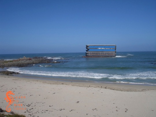
One of the most spectacular shipwrecks I’ve ever seen was that of the 100 metre long unmanned barge Margaret, which ran aground at Jacobsbaai on the West Coast on 24 June 2009. Margaret was carrying two halves of a floating dry dock and twelve river barges (positioned atop each other in side by side pairs, with two rows of three at the bottom). She was under tow by the tug Salvaliant from the Chinese shipyard where everything was manufactured, to Rotterdam. The barges were destined to transport cargo up and down the navigable rivers in Europe. During a winter storm, the tow parted, and Margaret and her cargo ran hard aground on the rocky reef just outside Jacobsbaai.
The eight storey pile of barges in December 2009
Salvaging the barges proved to be an almost intractable problem, so Margaret was still sitting firmly a couple of hundred metres off the beach when Tony and I visited six months after her grounding, in late December 2009. The stack of barges and two halves of a floating dry dock (the blue parts of the structure in the images) was clearly visible from a great distance. The sight was even more incongruous than that of the Eihatsu Maru aground on Clifton beach, which was a wreck-lover’s dream (but unfortunately not a permanent arrangement).
View of the barge Margaret from atop the sand dunes at Jacobsbaai
I wish I’d taken a picture of what the wreck looked like as we drove down the hill into Jacobsbaai, but you can see one here if you scroll around a bit. It looked like an office block rising out of the ocean. The wreck was so large that it was visible from almost every point in the sleepy town, and the brain struggled to make sense of the sight. It’s clear from the images what a challenge it must have been to tow the barge in the wind, as the forty to fifty metre high, perfectly flat sides of the stack must have provided tremendous resistance in a gale.
Portion of the barge wreck at Jacobsbaai
The owner ran out of money to continue salvage in February 2010, and Margaret was becoming increasingly damaged and unstable as time passed. The risk of the upper barges coming loose during another storm, and drifting away to cause a hazard to other ships or coming ashore on the beach, was great. It was decided by SAMSA to persist with an attempt to reduce the wreck, at taxpayers’ expense. Any money obtained by selling off the salvageable barges would go towards defraying costs.
During the salvage work on the barge Margaret
Salvage
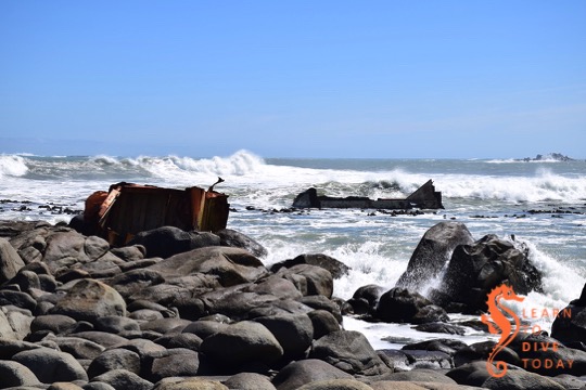
Tony and I visited the wreck again in April 2010, after the demolition that freed six of the topmost barges. The seaward wall of the upper piece of floating dry dock, weighing 91 tonnes, had been cut away to allow the barges to slide off freely.
The remains of the barge Margaret in April 2010
Over two tons of explosives were used in total. Small (125 kilogram) explosive charges were set off one after the other to create a ripple effect that dislodged the top six barges. These were towed to Saldanha, and then sold.
The wreckage of Margaret and her cargo in April 2010
If you like reading court judgments, here’s one in which the owners of the barges attempt to claim damages (massive ones) from the owners of the tug Salvaliant. There’s also a great collection of photos of the wreck in her various incarnations here.
The wreckage of Margaret in late April 2010
In late April 2012, Tony snapped this lucky shot of two of the barges leaving Simons Town harbour under tow. They’d been moored against the harbour wall for at least a month, to the consternation and fascination of the local paddling community.
Two of the salvaged barges leaving Simons Town harbour in April 2012
The remains of Margaret and her cargo were further demolished down to sea level and below, and now comprise an artificial reef. Fortunately there was no fuel or other pollutants in the stack of barges, which made the process significantly less polluting than it might otherwise have been.
The barge Margaret today
Tony and I visited Jacobsbaai to check out what remains of Margaret and her cargo in September 2018. The path to the wreck, which was formerly blocked off by hazard tape and “salvage in progress” signs, is wide and easily walkable. One can go right up to the rocks and view the wreckage from reasonably close up. Watch your foothold here, as it can be slippery and the rocks aren’t all firmly packed.
The remains of the barge Margaret and her cargo
Look out for a small memorial to one of the salvors, who passed away in an accident on the wreck during the course of the salvage operation.
Sharp wreckage sticking out of the sea
Parts of the wreck look like shark fins in the water, and it is possible that even more of it is visible at low tide.
The remains of the barge Margaret in 2018
You can find the wreck by turning off the R399 towards Jacobsbaai, and continuing towards the coast until the road becomes gravel. Carry on this road, and when you reach a T junction take a right turn to circle around the tiny, sheltered bay in front of you. When you can’t drive any more – there will be a small housing development in front of you – park the car and either walk up the steps on the dune to get onto the beach, or, preferably, through the houses. The paved area will give way to a wide gravel path that the salvors used to access the wreck. Continue straight along it and you’ll soon spot the wreckage on the rocks ahead and to your right. Co-ordinates are approximately -32.964140, 17.881612.
I never got around to sharing some of the maritime components of the trip Tony and I made to Sweden (for adventure) and Denmark (for family) in July-August of last year. I trust you will indulge me as I intersperse these recollections with our (not always so) regular programming.
When I do trip planning I tend to gravitate towards attractions and places that have something to do with maritime history and the marine environment – these subjects tend to make both of us happy. I became obsessed with visiting the Vasa Museum a few years ago, and when the opportunity arose to route our travels through Stockholm, I made it our first priority on our first full day in the city. If I had to provide a single reason for why we went to Stockholm, the Vasa might be it.
The Vasa museum
The Vasa was a Swedish warship that sank on her maiden voyage, within a stone’s throw of land and inside the collection of islands that makes up Stockholm, in the summer of 1628. She went down suddenly and quickly, and was lost until the 1950s, when the wreck was discovered in 32 metres of water in brackish Lake Malaren, just outside the harbour of Stockholm. The lake is connected to the sea, but the water is not salty enough to accommodate shipworms (Teredo navalis), and the absence of this wood-muncher contributed to Vasa‘s preservation. An extensive salvage effort culminated in 1961, and in 1988 the ship was moved to a dedicated museum on the island of Djurgården. The masts on the outside of the museum building aren’t original, but they show the height to which Vasa‘s actual masts would have reached.
Stern view of Vasa
Both the story of the Vasa‘s construction and sinking, and of her recovery and preservation, are remarkable. (I’ll leave you to discover why she sank.) I did a guided tour of the museum which provided some colour regarding the ship’s history before walking around on my own, but Tony preferred to explore independently from the beginning. The salvage process is well documented, as is life on board, characterised by some grim realities!
State of the art 1950s diving gear
A team of engineers works constantly to preserve the ship, which is closely monitored for structural and chemical changes, and kept in a strictly climate-controlled environment. The fruits of their research have assisted in the preservation of other historical vessels such as the Mary Rose in Portsmouth, and the parts of the exhibit related to the preservation of Vasa are fascinating in and of themselves.
First view of Vasa
I can’t adequately convey what it was like to walk into the museum for the first time and see a full-sized 17th century wooden warship right in front of us. Vasa is colossal, and breathtaking. So much of what I know about what life was like centuries ago has to be supplemented by imaginative reconstruction of things I’ve never seen before (like a wooden warship), or ambitious mental deletions of the industrial and agrarian features of almost all the landscapes one interacts with in developed countries. Seeing the Vasa was like a smack in the face from the past. Most of my photos are no good, because you’re so close to the damn thing, and it’s so enormous, that cameras just don’t do it justice. But your eyes do. If you’re anywhere remotely near Stockholm, get thee to the Vasa Museum. I promise you won’t regret it.
Sunday: Boat or shore dives in False Bay, meeting at 0900
Norwegian fishing vessel Nordervon in drydock at the Waterfront
According to our weather station this week, the south easterly winds have arrived, and hopefully this is a signal for warmer weather to move in.
False Bay has been on and off this week with some swell, however the colour is not too shabby. I am launching tomorrow, and depending on what we find, on Sunday I’ll shore dive at Long Beach or boat dive from False Bay Yacht Club. If you’d like to dive, let me know.
Pain Forms the Character: Doc Bester, Cat Hunters & Sealers – Nico de Bruyn & Chris Oosthuizen
Marion Island is one of South Africa’s two sub-Antarctic Prince Edward Islands, technically part of the Western Cape province. The South African National Antarctic Programme runs a meteorological and biological station there, dedicated to research. The researchers study weather and climate, ecosystem studies, seals (southern elephant seals, and Antarctic and sub-Antarctic fur seals), killer whales and seabirds such as albatross, that nest on the island. Researchers usually spend either three or 15 months at a stretch on the island, whose rugged terrain, intimidating wildlife and challenging weather can be said to “form the character”!
Pain Forms the Character
Marion Island is also infested by rats, introduced from whaling ships in the 1800s. With no predators, they multiplied to the extent that they threatened seabird populations. Cats were introduced in 1949, and by the 1970s there were 3,400 cats on the island. The cats ate mice, of course, and seabirds. An ambitious eradication program – of which our incredible friend Andre was part – eliminated the last of the cats in the early 1990s. The rat problem has resurged since the cats were removed, but work is in progress to get rid of them, too.
The research programs that currently exist on Marion Island are the legacy of Dr Marthan “Doc” Bester’s 40 year career as a scientist and researcher, and this book is a tribute to him. For this book, authors compiled photographs and testimonies from Bester’s colleagues, former cat hunters, and students, and he is the thread that ties this beautifully produced volume together. The focus is less on the scientific findings (you can find those online), and more on what it’s like to live on Marion Island, with the text complemented by many, beautifully evocative photographs.
Until recently, the last time I specifically went looking for the wreck of the Commodore II was in December last year, when I went to Milnerton lagoon beach to show visiting family the beautiful view of Table Mountain. At that time tides and waves had moved the wreck further away from the lagoon mouth, and she was lying on the sand at a spot that would be partially submerged at high tide.
Next time I went to look for the wreck, just after the Cape storm of 7 June this year, I couldn’t find it. A waiter at the Wang Thai restaurant on the beach told me he’d seen it all the way up at the old Wood Bridge at Woodbridge Island, and that people were removing pieces of the wreck and carrying them away. The storm surge had actually lodged the wreck partially under the old Wood Bridge (a sensitive National Monument constructed in 1901), and there was the potential for it to cause damage. There’s a picture of the wreck in this position on page 28 of this document (pdf).
Commodore II, secure for now
A few weeks ago Gerhard Beukes, a Milnerton resident, messaged me to say that he had secured the wreck about half way down the lagoon. It had been winched free of the Wood Bridge by Koos Retief, Area Biodiversity Manager at Table Bay Nature Reserve, and had floated back down the lagoon to settle on a sandbank near Gerhard’s home.
Chains and straps around the keelson
Mechanism by which the Commodore II is secured to the bank
Chains and straps around the keelson
Gerhard estimates that the wreck weighs about 25 tons, and with considerable personal effort and some financial outlay he has attached it to the lagoon bank, resting on the sandy bottom in shallow water, with chains and heavy lifting straps. The chain is secured to bolts attached to metal pipes sunk deep into the bank.
The Commodore II in Milnerton
The arrangement will prevent the wreck from washing around inside the lagoon and potentially injuring kayakers and other water users. It will also prevent it from washing out into Table Bay and becoming a semi-submerged shipping hazard, potentially lethal to vessels (something like the Seli 1 is when her buoy goes missing).
View towards Woodbridge Island
It’s also quite visible: if you walk or drive down Esplanade Street in Milnerton with Lagoon Beach behind you, you’ll come across the remains of the Commodore II next to the bank of the lagoon on your left. The wreck is over 60 years old, which means that under South African law it is protected and removing pieces of it is an offence. I hope that having many local residents’ eyes on the wreck will ensure it some measure of safety, even in the absence of any enforcement of the relevant laws.
How can you help?
To make sure the wreck does not come loose next time a large volume of water washes down the river and into the lagoon after heavy rains, it needs some further reinforcing in its current location. This could be done with a further 5 metre length of heavy duty chain, or (preferably) two loading slings, 25mm steel cable with rings or eyes on both ends. The harness needs to be capable of holding 25 tons of wood in place even under strain, and are necessary to completely stabilise the wreck.
If you have such items lying around unused at home, or are sufficiently moved and interested by the wonderful history of the Commodore II to make a donation, please comment on this post or use the contact form here, and I’ll connect you with Gerhard, the current guardian of the Commodore II.
Are you interested in shipwrecks that you can visit without going underwater? Read more about Cape Town’s visible shipwrecks here.
Into a Raging Sea: Great South African Rescues – Tony Weaver & Andrew Ingram
I insensitively packed this book for Tony to read while we were aboard MSC Sinfonia for the BirdLife cruise we took in April. It’s a rip-roaring read about various rescues that the NSRI has been involved with over the years, but – perhaps unsurprisingly – Tony wasn’t keen to read about maritime disasters (even ones that ended well) while we were at sea.
One of the things I loved about this book was that it reveals the men and women behind the daring, often dangerous rescues. The rescuers are allowed to recount the events they experienced, using their own words, and this is revealing. These rescuers are not usually lionised by the general public or, as a rule, afforded prolonged media attention, and neither does this book glamorise them or romanticise their achievements. The challenge of the rescues – and occasional raw fear felt by the rescuers – are vividly portrayed. The writing is beautifully matter of fact, without downplaying the seamanship, strength of character and perseverance required to do this (unpaid) work.
It reminded me fondly of the “drama in real life” stories that I used to devour from the pages of the Readers Digest magazines my grandmother used to bring whenever she came to visit. There are many, short chapters, each one offering its own little catharsis. The rescues span South Africa’s coastline, as well as a few other locations, and not all of them are maritime disasters.
Proceeds of this book support the NSRI. Get a copy for yourself, and all your friends. It will entertain anyone who loves a good story of heroism and adventure, and it will encourage anyone who’s feeling jaded about humanity’s capacity for good. It’s an excellent read.
You can find a copy on Loot if you’re in South Africa, otherwise here or here.