Franklin’s Lost Ship: The Historic Discovery of HMS Erebus – John Geiger and Alanna Mitchell
Franklin’s Lost Ship
Since reading The Man Who Ate His Boots, my obsession with the history of the exploration of the Canadian Arctic has not abated. You can expect to be troubled by many more Arctic book reviews and related material from me.
This book is a well-illustrated account of the discovery of one of Sir John Franklin’s ships, HMS Erebus, in the waters north of Canada. You will (may?) recall that Franklin’s entire expedition – some 130 men and two ships – disappeared while searching for the Northwest Passage, on a journey begun in 1845. Parts of the mystery of their disappearance, and what happened to them, have since been resolved, but until late 2014 ago no sign of either of the two ships had been found.
If you are interested in the story, this relatively short book both recounts what is known of Franklin’s expedition and the subsequent searches for him and his men, as well as detailing the recent discovery of HMS Erebus by a team of Parks Canada archaeologists. There are underwater photographs and side-scan sonar images showing the ship standing upright in about eleven metres of water. It’s an excellent complement to Anthony Brandt’s more detailed history, but can equally well be read on its own, as an account of history spanning 160 years, meeting technology from the present.
Some sections – such as the extensive and laudatory passages devoted to former Canadian prime minister Stephen Harper and his reflections on the discovery – were puzzling to me. I was pleased to see how much credit was given to the indigenous Canadian people and their maps and oral histories for their role in locating the ship. Their accounts of the fate of Franklin’s men, and clues as to the location of his ships, proved crucial in the discovery of HMS Erebus, despite being immediately disregarded by Franklin’s contemporaries.
You can get a copy of the book here (South Africa), otherwise here or here.
In the centre of Bredasdorp, the sleepy town in the Overberg that you will likely pass through on your way to De Hoop, Cape Agulhas, Arniston or any of the surrounding areas, is a museum devoted to shipwrecks. Tony and I paid it a visit while we were staying at De Hoop in September last year, and enjoyed it immensely. The museum is situated in an old church, and spills over into two other adjacent historical buildings.
Artefacts from SS Maori
The shipwreck museum contains artefacts from a wide variety of wrecks – many of them from the coastline between Danger Point and Cape Agulhas, but others from further afield (including our neck of the woods)! There is a display about SS Maori, including some of the pottery that was in the mixed cargo on the vessel.
Interior of the shipwreck museum
In addition to cargo items (including a vast array of bottles spanning a few hundred years of history), there are figureheads, binnacles, ship’s bells, cannons and anchors – the latter located outside in a beautiful garden behind the museum. The ship’s wheel of SS Kadie, wrecked at the mouth of the Breede River, is also on display. The Arniston,Queen of the Thames, and Birkenhead wrecks also feature prominently. Familiarising yourself in advance with some details about the most prominent wrecks of the Overberg region will enrich your visit.
Pottery from the Maori
Old fashioned diving helmet exhibit
The anchors in the garden at the museum
Ship’s wheel of the SS Kadie
Anchors in the shipwreck museum garden
Rocket-propelled breeches buoy apparatus
A separate garage-like structure (technically known as the Old Coach House), accessible over a tiny river bridge in the garden, contains a historical fire engine, carriages and other vehicles and implements of everyday life from a century ago. There is even a rocket-propelled breeches buoy apparatus, used from shore to rescue shipwreck survivors.
Tony for scale!
Another building included in the museum facilities is a fully furnished historical Overberg home called the Old Parsonage – when we walked through, there was even a (real live) cat having a cool nap on a hand-sewn quilt in one of the bedrooms.
Reminder about regulations pertaining to shipwrecks
If you’re in the area the Bredasdorp Shipwreck Museum is definitely worth a visit. Opening hours and contact details can be found here. The entry fee is minimal.
Plaque and Antipolis nameplate at the Twelve Apostles
MV Antipolis ran aground off Oudekraal, along the Cape Peninsula’s western coast, in July 1977. The wreck is visible at low tide, and can be seen from the deck at the nearby Twelve Apostles Hotel – you can admire it while drinking cocktails (or Fanta Grape, if you’re as wild as Tony and me) at the Leopard Bar.
Plaque commemorating wreck of the Antipolis
I was quite surprised to discover the (a?) nameplate of the Antipolis, along with a small plaque commemorating the wreck, on the large terrace adjacent to the Leopard Bar, which I accessed during the course of a very lovely wedding at the hotel. I am sure that if you asked nicely, or moved smoothly like a lizard, you could do the same, even without a wedding invitation in hand. You might be able to crane your neck from the deck of the Leopard Bar, too.
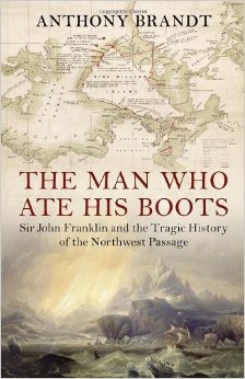
The Man Who Ate His Boots: The Tragic History of the Search for the Northwest Passage – Anthony Brandt
The Man Who Ate His Boots
The Northwest Passage is a sea route (routes, actually) running between Canada and Greenland, across the top of the North American continent through the Canadian Arctic Archipelago, and through the Bering Sea between Alaska and Russia. At its end is the Far East, for hundreds of years the destination of the thousands of sea voyages that made their way around the Cape of Good Hope, and later through the Suez Canal. Its existence was an enormously appealing idea to Europeans, because if the east could be reached by sailing along the top of the world, great savings of sailing time and expense would result.
For a long time the existence of the Northwest Passage was merely a hypothesis, and in the 1800s the British expended vast quantities of energy exploring the Canadian Arctic in search of a sea route. The passage was first traversed in 1850-54 by Robert McClure, by ship and sledge. Roald Amundsen traversed it entirely by ship in 1903-1906. Until this century, the route was not navigable for most of the year owing to the presence of sea ice. Now, thanks (?) to climate change, there is far less ice to contend with.
Sir John Franklin was one of Britain’s most eminent Arctic explorers. He made several trips to the Arctic in search of the Northwest Passage. His final expedition, starting in 1845, ended in the disappearance of his two ships (HMS Erebus and HMS Terror), Franklin himself, and all 128 of the men with him.
The story of his expedition, and the searches for evidence of its fate (upwards of 30 expeditions were mounted to look for him), and the subsequent discovery of what had happened (no spoilers here – it was awful) is related in gripping detail in The Man Who Ate His Boots. Brandt also provides ample historical context, describing prior expeditions which serve to illuminate the British motivations behind their exploration of the Canadian Arctic.
There was a curious mixture of stoic heroism and wild arrogance at work during this period of British history. The rigors endured by early Arctic explorers cannot be overstated – the environment is almost entirely hostile to human survival. The British did not believe that there was anything to be learned from the Inuit, indigenous people who live widely spread across the area, and suffered as a result. As one of the Inuit pointed out when the awful lengths Franklin’s men had gone to in order to try to survive were revealed, his people “know how to starve.”
There is a strong thread throughout this book relating to the colonial attitude towards colonised peoples. A belief prevailed in Britain that, equipped with a shotgun and a good pair of shoes, an Englishman could survive anywhere, and that his Christian piety would serve to protect him and speed his endeavours. (On one of Franklin’s earlier expeditions, which was a complete fiasco largely owing to poor planning, the British officers survived whereas the mixed-race local fur traders – who were doing all the manual work and carrying the supplies – perished. This was attributed to the protective influence of the Christian beliefs of the British men.) It was further reckoned that there was nothing to be gained from studying the techinques of the Inuit. Eyewitness accounts from Inuit turned out to hold the key to the fate of Franklin’s party, although their account was not believed initially (they were dismissed as habitually lying “savages”).
You can read reviews of The Man Who Ate His Boots at the New York Times, Washington Post, and The Guardian. If you enjoyed Endurance, then I recommend you investigate this book. In light of the developing findings of the excavation of HMS Erebus, the material has refreshed relevance today.
The mouth of the Breede River is a fascinating and beautiful location. There’s a treacherous sandbar (more on that just now). There are wide, natural vistas. There are sleepy holiday villages on each side of the river mouth. There’s an additional little frisson of excitement related to the fact that bull sharks use the Breede River, and must be passing by all the time (right?!).
When Tony and I were in the area for a spring break, we explored the area. I wanted to see whether I could find the remains of SS Kadie, a steaam-assisted sailing ship that is an integral part of the history of the area. The Kadie was built in Scotland in 1859, for the specific purpose of navigating the Breede River and up and down the coast, as a trading vessel. She did venture out to sea on longer voyages, on one occasion carrying a cargo of ostriches to Mauritius. (You can read a lot more about her history, and that of the Barry family who operated her, here.)
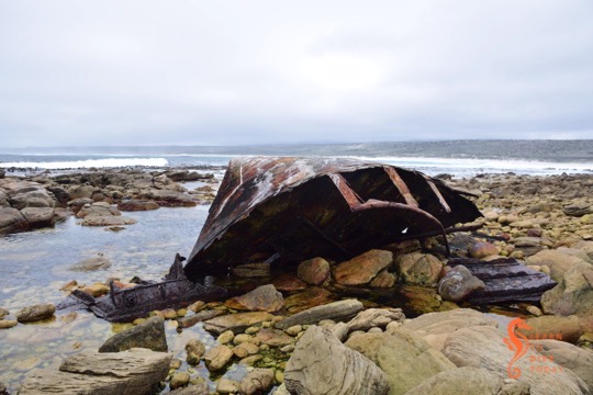
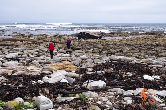
Wreckage of the Kadie inshore and further offshore
Rusting wreckage of the Kadie
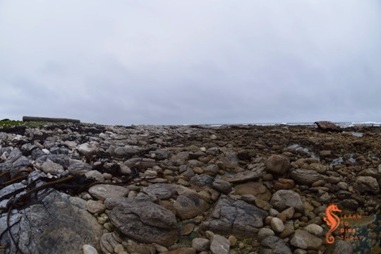
The Breede River estuary
The mouth of the Breede River (Infanta side)
Part of the Kadie in the surf zone
Remains of the Kadie
On 17 December 1865 the Kadie ran aground and sank while attempting to cross the sandbar at the mouth of the Breede River. She is easy to find, but you should visit at low tide. Take the turnoff to the river mouth from the dirt road to Infanta. It’s a small sign and easy to miss! Descend the wooden staircase onto the beach, and walk right. You will soon see pieces of the Kadie on the beach, in the shallow rockpools, and out in the surf zone. Best to go at low tide, or at least not at the peak of high tide.
The Japanese crew of the MFV Meisho Maru No. 38 could not have picked a more beautiful piece of South African coastline to run aground on. Granted, it was 3am on 16 November 1982 when they got into difficulties, and sightseeing was probably not high on their priority list, but the fact remains that the wreck is in a remarkably scenic spot. It is also within spitting distance (OK, two kilometres) of the lighthouse at Cape Agulhas.
It is also very easy to access. By foot, it is a flat walk along the coast for 1.5 kilometres from the signage at the southernmost tip of Africa. There is a well-kept dirt road out of L’Agulhas, which terminates at Suiderstrand, that runs parallel to the coast. If you drive along the road rather than walk next to it, you will see the wreck in short order.
The bow of the Meisho Maru 38
Here’s a picture of what the wreck looked like not long after grounding in 1982. (Compare it to these pictures of the Eihatsu Maru, aground at Clifton…) She was about 45 metres long, and was carrying a catch of tuna. Her entire crew (17 men) managed to get ashore All that remains now is the bow of the ship, facing out to sea after being turned around by the waves. When we arrived, some Egyptian geese were sitting pensively on the railings. The rest of the wreck has broken up and is hidden in the surf zone.
The Meisho Maru 38 wreck is an ideal resting place for birds
The bow of the Meisho Maru 38 facing out to sea
Meisho Maru 38
Decimal-form co-ordinates for the wreck are -34.829763, 19.983845, but if you drive from L’Agulhas towards Suiderstrand along the dirt road, you can’t miss it.
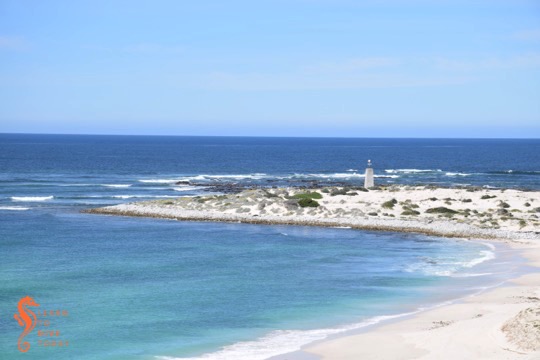
Just outside Arniston is the Cape Nature-administered Waenhuiskrans Nature Reserve. The famous Waenhuiskrans sea-cave is actually inside the reserve (which doesn’t appear to be fenced but is indicated with signage). We visited the area and drove into the reserve to the cliffs overlooking Otter Bay, where we had lunch. At the opposite end of Otter Bay to Arniston is Struispunt, which is in fact the eastern extremity of neighbouring Struisbaai.
Hundreds of gulls and cormorants perch on the rocks behind the Struispunt light
The beach at Otter Bay
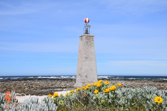
Struispunt marine light
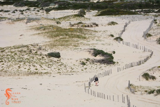
On Struispunt is a marine light, or beacon, which is essentially a wannabe lighthouse! I walked down the beach to visit it, and back on the sand road behind the beach. The beacon is a masonry tower 10 metres high, topped with a red and white striped globe for daytime navigation and a relatively small, solar-powered light (1,747 candelas) that flashes three times every fifteen seconds. The water off Struispunt is very shallow, only about five metres deep for some distance from the light, so its presence is essential.
Struispunt
The Struispunt light was erected following the wreck of SS Queen of the Thames, in 1871. It is visible for 11 nautical miles. Its western and eastern sides were painted red and white for a while, but most of the paint has worn off and I could only discern a faint reddish tinge. Behind the light, on the rocks, many gulls and cormorants were roosting when I visited. There were also some human fishermen nearby!
Tony took this picture of me walking back from the light
If you’re planning a trip to Cape Town and have a love of shipwrecks on shore, you’re in luck. Visiting some of the wrecks that are visible above the water around the Cape Peninsula can be combined with your exploration of the city, and will ensure that you don’t miss any of its outdoor highlights. Some of these visible shipwrecks can be reached by road, and one or two of them will require a short boat ride.
A map showing all these wrecks can be found here. A mini travel guide to Cape Town’s shipwrecks on shore, in the form of an ebook entitled Cape Town’s Visible Shipwrecks and written by yours truly, is available here.
In addition to the general shipwreck artefacts on display at the museums listed above, you can check out the following specific wreck remains, some of which are not labelled or take a little bit of finding:
The wreckage of the Phyllisia, and a huge log on the beach
There are three visible shipwrecks inside the Cape Point section of Table Mountain National Park. Two of them, the Thomas T Tucker and the Nolloth, are accessible along the Shipwreck Trail in the nature reserve. The third, the Phyllisia, is visible at the turning point of a walk called the Phyllisia Circuit, that starts and ends at Gifkommetjie in the south western part of the reserve. (The formerly visible wrecks, the Tania at Buffels Bay and the Shir Yib at Diaz Beach, are no longer visible, having been reclaimed by the sea.)
Tami and Maria on the rocks in front of the Phyllisia
The Phyllisia was a Cape Town fishing trawler of 452 tons. She struck submerged rocks a short distance offshore, close to midnight in early May 1968. Holed in four places, she was partly submerged but remained intact for some time. Eleven of her crew came ashore in life rafts, and the remaining 14 were airlifted off by helicopter.
Approaching the Phyllisia over the rocks
The stern of the Phyllisia
The Phyllisia is best visible at low tide
Initial plans to salvage the wreck were scuppered by continued heavy weather, and after the removal of the moveable equipment from the ship, she and her cargo of 30 tons of fish were left to the elements. All that remains of the wreck on the shore is part of her stern.
A cloudy day at the Phyllisia
The walk to the Phyllisia from the Gifkommetjie parking area is about 2.5 kilometres, and I will describe the route in more detail in a separate post about the Phyllisia Circuit. She is best visited at low tide, so that what remains of her stern is fully exposed on the rocky shore. Look out for the various smaller bits of metal in the area, and also for the massive log that probably has the same origin as the one at Olifantsbos.
The Antipolis lies against the shore in a small rocky bay
The oil tanker Antipolis ran aground off Oudekraal during a July storm in 1977. She and the Romelia, which is wrecked near Sandy Bay, were both under tow by the tug Kiyo Maru No. 2 from Greece to be scrapped in Taiwan. The wreck lies pointing shoreward, a couple of hundred metres south of the 12 Apostles Hotel. She can be viewed from a vantage point above a storm water drain between the hotel entrance and a small parking area on the opposite (seaward) side of the road. Walk along the Armco barrier from the parking area, looking to your left (while also looking out for cyclists). The storm water pipe is about twenty metres from the parking area and is marked by a gap in the bushes through which the wreck can be seen.
There is also the option of climbing down an impossibly steep and slippery path onto the rocks adjacent to the wreck. The view from here is slightly better, but it is not a climb for the faint hearted.
Bow section of the Antipolis at low tide
View of the Antipolis from the rocks
View of the Antipolis from the road
She is now a beautiful dive site if you visit in clear, calm conditions. Most divers shore dive off the rocky beach in front of the wreck, after climbing over the traffic barrier and walking over the boulders on the shore.
There are some pictures of the tanker just after she grounded here and here (the comments are also worth reading). Her superstructure was cut off some time later for scrap. The entire shape of the wreck can be discerned on aerial images, as much of her lies just below the waterline.