The Cape Point Shipwreck Trail

Burned landscape near Olifantsbos

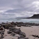
Lovers of shipwrecks and wilderness will enjoy the Shipwreck Trail (also called the Thomas T Tucker Trail, which has a nice alliterative ring to it) in the Cape Point Nature Reserve. Tami, Maria and I did it on one cloudy Saturday, close to low tide. (You can do the walk at high tide, but you won’t be able to get as close to the wrecks and some parts of the wreckage will be underwater.) The trail starts from the Olifantsbos parking area inside the reserve. There is a large sign saying THOMAS T TUCKER, which will send you on your way. A waist-high pyramid-shaped cairn of stones indicates where you must climb over the dunes onto the beach – the actual path is hard to discern at this point owing to fire damage.

Rockpools abound near Olifantsbos

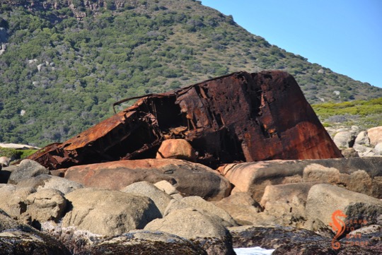
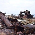
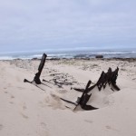
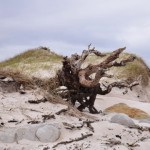
The path follows the coast past the Olifantsbos Cottage to the next beach, where the remains of the Thomas T Tucker are strewn around. Don’t rush past the beach outside Olifantsbos Cottage, though – there is a huge wooden log, bored by teredo worms, with rust marks at its base showing where it was attached to the deck of a ship or where fittings for lifting by crane were located.

It is possible that this is one of several hundred okoume logs that came off a cargo vessel called Lola in Table Bay in 2008. The ship was apparently in very bad repair. Similar logs can be found at Hoek van Bobbejaan, Sandy Bay, and other locations along the Atlantic coast. (Incidentally, those logs were predicted to cause havoc in the 2008 storm that uncovered the wreck of the Commodore II.)

The mast on Olifantsbos beach

On the beach near the Thomas T Tucker you will also see some whale bones, which are becoming more and more damaged with each passing selfie, but are still impressive in scale. I suspect that more of that skeleton is on display at the Buffelsfontein Visitors Centre near Buffels Bay in the park.

Whale skull near the Thomas T Tucker

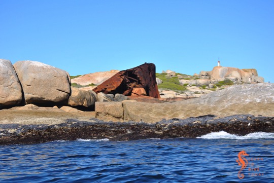
Continuing past the main wreckage of the Thomas T Tucker you will come across another small piece of rusty metal, which belongs to the same wreck even though it is so far away from the rest of the debris. Shortly you will spy the wreck of the Nolloth on the beach before you. Don’t overlook the rockpools on the way.

Moody skies over Misty Cliffs

The route back can either be a retracement of your steps along the coast, or via the inland path marked by a sign on the edge of the beach just past the Nolloth. We struggled a bit to find the path as the plant life in the area has not recovered since the March fires, and in retrospect we’d probably have gotten on much better (and returned home much cleaner) if we’d just walked back along the beach!

Baboon footprints on Olifantsbos beach

You shouldn’t do any walking in the reserve without a proper map; my favourite is the Slingsby Map series. I got mine from the curio shop at Kirstenbosch, and they are available at most major bookstores (with a bias towards those in the south peninsula – I have seen them at both Wordsworth and at the Write Shoppe in Long Beach Mall). Be aware of and grateful for the baboons, don’t advertise your snacks, don’t go alone, and always take something warm with you even if it’s a sunny day when you set out.

Three adventurers at the Nolloth - me, Tami, Maria
Three adventurers at the Nolloth – me, Tami, Maria

In case you missed the links in the text, check out the separate posts on the two wrecks you’ll see along this trail: the Thomas T Tucker and the Nolloth.

If you’re interested in visible shipwrecks, check out my ebook Cape Town’s Visible Shipwrecks: A Guide for Explorers!

The new Cape Point lighthouse

View of the new Cape Point lighthouse from the sea

To me it would seem totally logical to build a lighthouse as high above sea level as possible. As we saw with the old Cape Point lighthouse, there is such a thing as too high, particularly when you’re building in an area that is prone to heavy mist and fog. The most notable shipping casualty that occurred after construction of the old Cape Point light was that of the Lusitania, wrecked on Bellows Rock in 1911. A new lighthouse was planned, along with a light at Slangkoppunt in Kommetjie, to replace the old light at Cape Point.

View of the new lighthouse at Cape Point

The new lighthouse was built on a 15 metre high pinnacle of rock called Diaz Point, which was dynamited to form a flat platform upon which the lighthouse would be built. Building materials were hauled by oxen from Simon’s Town, and transported by tram down a track on the cliffs. Most of the way the gradient of this tram track was 1 in 4; for a short stretch it was 1 in 2. This is incredibly steep. At the end of the tram track, the building materials were lowered by crane onto a ledge. Building sand was excavated from a cave at the bottom of the cliff, and carried up to the platform on which construction took place. Water was brought close to the building site by trolley, and piped down onto the location.


Like the old lighthouse, the new lighthouse is nine metres high, but instead of cast iron, it is constructed from masonry and the tower is square. The lantern house on top is white. The new lighthouse’s elevation is 87 metres above sea level, giving it a range of visibility of 32 nautical miles. The fully automatic light flashes three times every 30 seconds, and there is a subsidiary red light in the base of the lighthouse facing towards Anvil and Bellows Rock. This light is only visible from the sea, if you go around Cape Point to the western side of Cape Point.

On 11 March 1919 the new lighthouse was commissioned (put into service). The view from this lighthouse covers a full 353 degrees, with seven degrees obscured by Da Gama Peak behind it. It was manned for a time, but is now automated.

Getting closer to the new lighthouse

The public is not allowed to visit the new lighthouse, or even to get particularly close to it. It can be viewed from a viewpoint at the end of the Lighthouse Keeper’s Trail, a highly recommended short walk from the old lighthouse at Cape Point. Along the way you will see the remains of World War II bunkers and a radar station, and you will traverse the most fantastically narrow ridge of rock (in perfect safety). The wind is likely to be extremely strong, whatever time of year you go – dress accordingly. Also note that the walk does not take nearly as long as is suggested by the signage at the start. It is approximately one kilometre each way.

View from the old lighthouse towards the new one

As usual, everything I know about this lighthouse that I didn’t learn by looking at it (i.e. most everything), is thanks to Gerald Hoberman’s wonderful Lighthouses of South Africa book.

Cape Town’s visible shipwrecks: MFV Harvest Capella

The rocky peninsula at the northern end of Maori Bay, on the opposite side of the bay to the MV BOS 400 crane barge wreck, is called Oude Schip. It can be reached by walking and bouldering from Llandudno, or, as we (predictably) prefer, on a boat ride out of Hout Bay. We are usually in the area with the aim of diving the wrecks of the Maori, the Oakburn or the BOS 400.

High and dry at Oude Schip

On the rocks at Oude Schip are the remains of a Sea Harvest fishing vessel called MFV Harvest Capella. This 44 metre long diesel trawler ran aground in early October 1987, apparently during a south easterly gale. There are some pictures of her aground here and here.

MFV Harvest Capella at Oude Schip

Over the years, part of her bow has been pushed right up onto the rocks by the force of the waves. At the same time it has been breaking up, and perhaps in a few years will be almost indiscernible. The wreckage is quite unstable, and not really suitable for clambering about in any more.

MFV Harvest Capella on the rocks behind our boat

Next time you’re in the area, ask your boat skipper to take you towards the rocks on the Sandy Bay side of Oude Schip to see how the Harvest Capella is looking these days!

If you’re interested in visible shipwrecks, check out my ebook Cape Town’s Visible Shipwrecks: A Guide for Explorers!

Cape Town’s visible shipwrecks: Winton and Hermes

Being (in midlife) a creature of the south peninsula, I tend to focus my attentions on False Bay and the Atlantic coast from Hout Bay southwards. But there are rewards for the shipwreck hunter who ventures further north, and even for the shipwreck hunter who doesn’t necessarily want to get their feet wet. A visit to Milnerton beach, and a walk north from Milnerton lighthouse, reveals two shipwrecks in the surf zone. Milnerton beach is surpassingly filthy, but while I was there a beach cleanup was making some headway on the mounds of rubbish tossed off ships in Table Bay that ends up on the beach. The view of the lighthouse from the beach is also far more fetching than the view from the car park, if you can overlook the garbage.

Milnerton lighthouse

About one kilometre north of the lighthouse, where the beach is cleaner and pebbles roll euphoniously in the waves, you will come across the massive boilers of the Hermes in the surf. The NSRI gets calls every year from concerned locals worried that a whale is stranded near the beach; the sea spray sometimes pushes through holes in the top of the wreck creating an illusion of a whale’s blow. The Hermes was a liner, built in 1899, on her way to Cape Town with a large cargo of livestock, forage and a few passengers. When she arrived in May 1901 the harbour was full, and she was forced to drop anchor for the night. A north westerly gale came up, she dragged her anchors, and when the captain ordered her engines started, they failed.

Hermes (front) and Winton (back)

Seawards and to the north of Hermes, the engine block of the Winton is visible, in much the same way as the SS Clan Stuart can be seen at Glencairn in False Bay. The Winton came aground in July 1934, carrying a cargo of wheat from Port Lincoln in Australia to Liverpool, England. Her captain was unfamiliar with Table Bay and had mistook the red lights on top of the radio mast at the Klipheuwel Wireless Telegraph Station near Milnerton for the harbour lights. Attempts were made to pull her off the beach and some of her cargo was salvaged, but the wheat ignited and efforts to refloat her were to no avail.

On a calm day, an aerial view of the site reveals the full outline of both vessels surrounding the parts that protrude from the water. When I visited, it was rough after a large swell, but the tide was low. At high tide the view will be considerably less impressive.

The boilers of the Hermes in front of Table Mountain

It is possible to scuba dive this site, and Underwater Explorers dives the Winton every year during their summer Table Bay wreck diving jamboree. Obviously very calm, low swell conditions are required because the wreck is so shallow and so close to the beach.

If you’re interested in visible shipwrecks, check out my ebook Cape Town’s Visible Shipwrecks: A Guide for Explorers!

Cape Town’s visible shipwrecks: Commodore II

We first saw the Commodore II on Lagoon Beach, Milnerton, when we went to Sophie and Jacobus’s wedding. It was a summer’s day, and she had a boogie board and a pool noodle lying on her keelson, a bride and groom (not Sophie and Jacobus) posing for photos on her, and a gazebo secured to some of the rivets protruding from her timbers. I was fascinated by the strength and size of what remains of the ship, and returned on a clear winter morning, before the beach filled up, to look at her again.

The Commodore II was a four masted schooner built in the United States, with a film credit as one of the sets in the 1935 Clark Gable film Mutiny on the BountyPrivately owned, she ended up in Durban in the late 1930s and fell into disrepair after her owner died.

Commodore II in Table Bay

She was then towed to Saldanha, where she became a floating coal hulk during World War II. After the war she transported coal to South America and timber back to South Africa, but according to one of her crew, the ship ran into many difficulties and conditions on board were dire.

It was either in 1945, 1946 or 1948 (sources differ but I tend to believe the 1946 or 1948 dates) that she was set on fire and allowed to run aground off Milnerton. This was apparently considered an acceptable way of disposing of the vessel.

Not done yet, the Commodore II made an appearance in 2008, when a storm uncovered her remains at Milnerton. At the time the Cape Argus published an interview with one of her former crew, who described his love for the ship and described some of her history. I’m not sure of the status of the wreckage between 2008 and 2013, but the NSRI suggests that during that time the wreck washed into Milnerton lagoon and was secured inside the lagoon by residents who feared for the safety of water users if she was left to move about at will.

Steam rises off the Commodore II in the morning sun

In September 2013 she came loose and washed out of the lagoon onto the beach. City officials promised to remove her, but two years later they still have not (for which I am glad). Today she lies in front of the Lagoon Beach Hotel, at times right on the edge of the Milnerton lagoon mouth (which moves around on the beach a bit). It is quite conceivable that another storm will wash her off the beach, back into the lagoon, or to a slightly different location, but for now she makes for an arresting sight on a crisp morning.

Finally, because it’s special, here’s one of the official trailers for Mutiny on the Bounty, featuring the Commodore II. I assume that’s her in the long shots, and perhaps the deck and below-deck scenes were also filmed on her. Enjoy –

[youtube=”https://www.youtube.com/watch?v=aFalJyGNGmE&w=540″]

If you’re interested in visible shipwrecks, check out my ebook Cape Town’s Visible Shipwrecks: A Guide for Explorers!

Mouille Point lighthouse (decommissioned)

The base of the Mouille Point lighthouse at Granger Bay

We aren’t done with lighthouses yet. One of the ones I haven’t told you about is the old Mouille Point lighthouse, which is located in Granger Bay. This is what I used to interchangeably call the lighthouse at Green Point, but in fact they have always been two entirely different entities. The Green Point lighthouse was built in 1824, and was the first lighthouse in South Africa. The lighthouse at Mouille Point, a few kilometres down the road, was built in 1842 and decomissioned in 1908 when a light was established on the breakwater (or mole, hence the name) at Mouille Point making the light redundant.

This lighthouse was a beautifully cylindrical tapering tower, with horizontal stripes up its length. The base of the old Mouille Point lighthouse still stands, on the grounds of the Cape Technikon Hotel School. It is behind a parking boom, but if you speak politely to the security officials they will let you walk onto the premises to take some photographs. When I visited there was a wedding going on, and it took some manoeuvring to take these pictures without guests appearing in them!

Bookshelf: Pirate Hunters

Pirate Hunters – Robert Kurson

Pirate Hunters
Pirate Hunters

For the days that I spent listening to the Pirate Hunters audiobook on the way to and from work (I have a long commute), I was transported from wintry Cape Town to a sandy bay in the Dominican Republic, to the Archive of the Indies in Seville, Spain, and to the deck of a pirate ship in the seventeenth century.

Friends John Chatterton and John Mattera undertake an obsessive quest to locate a vessel that belonged to the legendary pirate Joseph Bannister. There are accounts of the battle that claimed his ship, but not enough evidence to   The life of a treasure hunter may appear romantic from the outside, but in reality it is expensive, monotonous, and frustrating – punctuated with moments of delirious elation. (Treasure – The Search for Atocha also gives an excellent perspective on this irony.)

Robert Kurson is the author of Shadow Divers (gripping), which also features veteran wreck diver John Chatterton as he embarks on a dangerous quest to identify a sunken submarine in the North Atlantic. Unlike Shadow Divers, diving is not as much of the focus in Pirate Hunters. The diving that does take place is in shallow, light-filled tropical water and entails minimal risk to the participants. In both books, however, there is an intense focus on the historical research that is required to positively identify a shipwreck. In Pirate Hunters, Kurson does an excellent job of taking us inside the mind of the pirate Bannister, and it is through a thorough understanding of his motives and character that Chatterton and Mattera make their biggest breakthrough.

Check out the New York Times review of the book, which does highlight some of its shortcomings relative to Shadow Divers. If you’re pirate obsessed or a maritime history buff, however, you’ll enjoy Pirate Hunters regardless.

You can pick up a copy of the book here, if you’re in South Africa, otherwise here or here.

Cape Town’s visible shipwrecks: Nolloth

The engine block of the Nolloth in the foreground

The second visible shipwreck along the Cape Point Shipwreck Trail, about three kilometres from the start in the Olifantsbos parking area, is the Nolloth. She was a Dutch coaster carrying a cargo of (mostly) liquor, and struck a submerged rock (probably Albatross Rock, nemesis of many ships) off Olifantsbos in April 1965. Her captain ran her aground to save the cargo and prevent loss of life. Customs officials swiftly salvaged the cargo!

Engine block of the Nolloth

The Nolloth lies just in the waves at high tide. We visited a couple of hours after high tide, and were able to walk all the way around the wreckage without getting our feet wet. She lies at an angle, with much of her seemingly buried in the sand. Her engine block is partially exposed, and for the mechanically minded, prolonged examination of the cogs and gears will be rewarding.

Ribs of the Nolloth
Ribs of the Nolloth

The wildness of the location lends a very special quality to this wreck that is lacking in Cape Town’s visible shipwrecks that are situated in more urban environments – RMS Athens comes to mind. It is a remote and very beautiful spot, but would be possessed of far fewer benign qualities on a dark and stormy night.

There are some fantastic pictures of the Nolloth in Brian Wexham’s Shipwrecks of the Western Cape, taken, I suspect, within 20 years of her running aground. There is far more of her visible – she looks like a ship on the beach rather than a ship in the beach! There is also evidence of some low wreckage in the shallows that might still be visible when the tide is at its nadir, but I would caution against too much barefoot exploration of rockpools unless the water is very clear and your tetanus shots are up to date.

The Nolloth on the beach south of Olifantsbos

The Nolloth signals the point at which one turns back along the Shipwreck Trail to head towards Olifantsbos once more. Tami, Maria and I spent a wonderful morning on the Shipwreck Trail exploring the Thomas T Tucker and the Nolloth. As an aside, I would like to apologise to the resident chacma baboons for disturbing the peace when I realised that – with the help of a Slingsby Map – I had in fact successfully navigated us (along a marked and named trail, mind you) to not one, but two shipwrecks.

If you’re interested in visible shipwrecks, check out my ebook Cape Town’s Visible Shipwrecks: A Guide for Explorers!

Cape Town’s visible shipwrecks: Thomas T Tucker

The first boiler of the Thomas T Tucker you'll come across
The first boiler of the Thomas T Tucker you’ll come across

If you’re a fan of visible shipwrecks, may I recommend the Shipwreck Trail in the Cape Point section of Table Mountain National Park? I’ll write a separate post just about the trail, but this post and the one that follows (about the Nolloth) concern two shipwrecks, high and dry on the shore, that can be see on the route.

Three large pieces of the Thomas T Tucker on the rocks

The SS Thomas T Tucker was an American-built Liberty ship. These cargo vessels were of a standardised design and were built in great numbers, and at great speed, during World War II. They were used to transport war materiel to the Allied troops, and this is what the Thomas T Tucker was busy doing when she found herself off Olifantsbos in November 1942. She was on her maiden voyage from New Orleans to Suez, hugging the coast in a thick fog for fear of German U-boats.

The Thomas T Tucker's second boiler, high on the beach
The Thomas T Tucker’s second boiler, high on the beach

When she ran aground on 27 November (our wedding anniversary!), her captain reported that the ship was aground on Robben Island, which is over 40 kilometres to the north. The ship’s compass was found to be out by 37 degrees, which may have contributed to the accident.

Today the Thomas T Tucker is beautifully spread out on a beach about two kilometres from the parking area at Olifantsbos, inside the Cape Point Nature Reserve. She was 135 metres long, so there was a lot of ship to distribute. There are some great pictures in Shipwrecks of the Western Cape by Brian Wexham, from (I think) the 1980s. They give a good idea of how the wreck has deteriorated.

You will first come upon one of her boilers, high up on the beach, close to a small headland. If you look back the way you’ve come (first photo, above) you can see Misty Cliffs, Scarborough and – perhaps – Slangkop Lighthouse. Beyond that she is in several large pieces on the rocks, and higher up the beach. A third (bonus!) section of wreckage lies a couple of hundred metres further along the Shipwreck Trail (also called the Thomas T Tucker trail), so isolated from the rest of the wreck that I at first thought that it came from a different ship.

The "bonus wreckage" of the Thomas T Tucker further along the beach
The “bonus wreckage” of the Thomas T Tucker further along the beach

We visited the wreck of the Thomas T Tucker an hour or two after high tide. At low tide, all the pieces of the wreck are accessible; we could not reach the most distant piece without getting our feet wet! There is some wreckage that isn’t visible, lying in the shallow water, which you can visit on a scuba dive if you get the appropriate permission to have dive gear on a boat within the exclusion zone around Cape Point. We were lucky to have fairly dramatic skies for photography. The way in which the wreck is scattered is a testament to the exposed nature of this coast, and the power of the Atlantic Ocean.

If you’re interested in visible shipwrecks, check out my ebook Cape Town’s Visible Shipwrecks: A Guide for Explorers!

Shipspotting: Golar Penguin and passengers

On the way back from Big Bay at the end of the Lighthouse Swim, Tony and I stopped by the Seli 1 and then checked out the ships waiting outside Table Bay harbour. One of them was the Golar Penguin, a LNG carrier.

Golar Penguin
Golar Penguin

She is under the flag of the Marshall Islands. This is a flag of convenience (though, it seems, quite a reputable one), and if you want to know more about the legal implications of the fact that 40% of all world shipping by deadweight tonnage fly Panamania, Liberian or Marshall Islands flags, I suggest you pick up the excellent book The Outlaw Sea by William Langewiesche.

Most interesting to us, however, was the small group of Cape fur seals basking in the sea on the ship’s bulbous bow, which was sticking quite far out of the water because she seemed to be unladen. The purpose of this bow shape, which is only effective on ships above a certain size that cross large bodies of water, is to reduce drag, increase speed and to improve fuel efficiency.

Seals in the sun
Seals in the sun

The seals, however, like it as a haul out spot. Who are we to argue?