Directions to Oceana Power Boat Club

Boat dives in Cape Town are either done from Miller’s Point, Hout Bay, or (less frequently) Oceana Power Boat Club near the Waterfront. Don’t expect to see a giant inflatable duck there.

Helga and a duck on the OPBC slipway

Launches are done from the Power Boat Club when wind conditions necessitate being sheltered by the mountain (for example in a strong southerly wind during the summer). Here are directions from the entrance to the V&A Waterfront at the start/end of the N2:

  1. Drive into the Waterfont.
  2. At the circle, take the first exit to the left. Behind you on your right will be a Caltex garage, and in front on the right is the Clock Tower precinct.
  3. Follow Dock road through the Waterfront, past the Two Oceans Aquarium on your right.
  4. The road curves to the left, and at the top of the hill go straight through the circle. The Pavilion Conference Centre is on your left, and then Somerset Hospital steps.
  5. At the circle at the bottom of the hill, go straight through.
  6. At the next circle, take a left. You’ll reach Beach Road, which heads into Sea Point.
  7. You won’t go that far, though – take your first left off Beach Road into Jetty street.
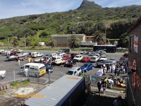
  8. The Power Boat Club is in front of you just as the road starts to curve to the right. You can park in the parking area if there’s space, otherwise on the side of the road.

Here’s the Power Boat club from above. The launch site is that unassuming half moon in the centre of the map.

[googlemaps http://maps.google.com/maps?f=q&source=s_q&hl=en&geocode=&q=oceana+powerboat+club,+waterfront,+cape+town&sll=37.0625,-95.677068&sspn=34.861942,58.798828&ie=UTF8&oi=localspell&cd=1&hq=oceana+powerboat+club,+waterfront,&hnear=Cape+Town,+Western+Cape,+South+Africa&t=h&ll=-33.901036,18.415575&spn=0.003117,0.00456&z=17&output=embed&w=425&h=350]

Directions to Hout Bay harbour launch site

Boat dives in Cape Town are either done from Miller’s Point, Hout Bay, or (less frequently) Oceana Power Boat Club near the Waterfront. Tony is often asked for directions to the slipway in Hout Bay harbour, and I am the one who has to write them (being the native Capetonian!). Here they are for future reference:

Coming from Central Cape Town:

  1. Get onto Kloof Nek drive and follow it over the mountain until you can see Camps Bay below you.Turn left at Houghton Rd (500 metres).
  2. Slight left at Victoria Rd/M6, and carry on past the Twelve Apostles Hotel at Oudekraal, and Llandudno (9.4 km).
  3. Descend into Hout Bay and bear slight right to stay on Victoria Rd/M6
  4. Continue to follow Victoria Rd (1.8 km).
  5. At the roundabout, take the 2nd exit onto Harbour Road
  6. Continue down Hout Bay Harbour Rd.
  7. Turn left into the harbour entrance below the stone cliffs.
  8. Turn right at the booms and follow the road for no more than 200 metres until you see the slipway on your left, next to the NSRI building.

Coming from the Southern Suburbs (Rondebosch, Claremont, Newlands, etc):

  1. Get onto Constantia Nek, and at the top take the Hout Bay turnoff.
  2. At the first roundabout you get to in Hout Bay, take the 1st exit onto Main Rd/M6 (1.4 km)
  3. Drive past the mud soccer fields on your right, Kitima Restaurant and a petrol station on your left.
  4. At the next roundabout, take the 2nd exit onto Princess Street
  5. Directions as from Item 6 above.

Coming from the South Peninsula (Glencairn, Fish Hoek, Simon’s Town, etc):

  1. Follow Chapman’s Peak drive to its end in Hout Bay. The toll is about R40 unless your car is a bus.
  2. At the roundabout, take the 1st exit onto Princess Street.
  3. Directions as from Item 6 above.

Here’s an aerial view of the relevant parts of Hout Bay Harbour. The entrance road is right at the top of the map, in the middle. The slipway is more or less in the middle of the map, to the right of the dusty parking area. You’ll park your car in the parking area just at the top of the slipway, or in the dustbowl if the paved area is too full.

[googlemaps http://maps.google.com/maps?f=q&source=s_q&hl=en&geocode=&q=hout+bay+harbour&sll=-34.049944,18.345087&sspn=0.002227,0.003605&ie=UTF8&hq=&hnear=Hout+Bay+Harbour,+Hout+Bay,+Cape+Town,+Western+Cape,+South+Africa&t=h&ll=-34.050019,18.34587&spn=0.003111,0.00456&z=17&output=embed&w=425&h=350]

Directions to Miller’s Point launch site

Boat dives in Cape Town are either done from Miller’s Point, Hout Bay, or (less frequently) Oceana Power Boat Club near the Waterfront. Tony is often asked for directions to Miller’s Point, and I am the one who has to write them (being the native Capetonian!). Here they are for future reference: (Launch fee is currently R80.00. June 2013)

Coming along the Main Road:

  1. This is easy. Keep on the Main Road through all the coastal suburbs – Muizenberg, St James, Kalk Bay, Fish Hoek.
  2. At the circle at the top of Fish Hoek Main Road, keep left and stay next to the sea. You are basically following the railway line along the coast.
  3. Carry on through Glencairn, and into Simon’s Town.
  4. Drive through Simon’s Town, past the golf course on your left, and the turnoff to Boulder’s Beach.
  5. Continue for several kilometres until you see a sign for the Black Marlin seafood restaurant and Miller’s Point caravan park on your left (in the middle of nowhere – no houses or anything).
  6. Now keep your eyes open – the Miller’s Point turnoff is the next one on your left, around a courner and over a small hill. Drive in and into the lower parking area (not the one immediately on your right as you enter, but in front of you to the right). The boats park in the upper parking area so don’t go in there.

Coming on the M3 highway:

  1. When you get to the end of the M3, turn right at the traffic light and contine through one more set of lights (Virgin Active on your right).
  2. Just before the next set of lights take the slipway to the left, up onto Ou Kaapse Weg. This turnoff is not well signposted!
  3. Now you basically stay on the same road until it ends abruptly in the ocean. Go over Ou Kaapse Weg into Sun Valley.
  4. Continue straight through two sets of traffic lights (stopping if they’re red), onto the Glencairn Expressway (Blackhill Road). This takes you over a small mountain into Glencairn.
  5. When you get to the sea, with a Spar on your left and a wetland on your right, turn right. Now you are on the Main Road.
  6. Directions continue as from Item 3 in the Main Road section above!

Here’s an aerial view of the launch site. The slipway is at the end of the T-shaped piece of road towards the top of the promontory.

[googlemaps http://maps.google.com/maps?f=q&source=s_q&hl=en&geocode=&q=miller’s+point,+south+africa&sll=-34.230672,18.474433&sspn=0.004444,0.00721&ie=UTF8&hq=&hnear=Millers+Point+Rd,+Murdock+Valley,+Cape+Town,+Western+Cape+7975,+South+Africa&t=h&ll=-34.231709,18.474498&spn=0.006209,0.00912&z=16&iwloc=A&output=embed&w=425&h=350]

You can zoom out on this map to see where Miller’s Point launch site sits relative to everything else. If you continue along the M4 (Main Road) past Miller’s Point, you will eventually get to Cape Point.

Things to be aware of

  • Miller’s Point is part of the stamping ground of a large troupe of baboons. They are hilarious to watch, but (especially if you’re a woman) the large males can be a bit intimidating. Keep your car locked, windows closed and sunroof securely shut in order to prevent them from raiding the vehicle for food – they know how to open almost anything, and will get into the car with you if they see the opportunity. DO NOT feed them.
  • Sometimes there’s a guard at the boom who wants an entry fee (I think it goes to the government). It’s less than R10 but make sure you have some small change on you.
  • There are no ATMs, shops or any other signs of civilisation at Miller’s Point. There are public toilets near the slipway, but their condition is wildly variable and you should take it as a given that there are no seats or loo paper.
  • Lately some of the boat skippers have been launching from the slipway at Cape Boat and Ski Boat Club, which is on the right hand side as you enter Miller’s Point. Be sure to check which slipway you’re launching from, as it’ll affect which parking area you’ll be meeting the dive boat in.