Date: 6 April 2014

One Sunday in early April, Tony did a very early launch for an Aquaventures PADI IDC, taking the divers to the wreck of the BOS 400 and to dive with seals at Duiker Island in Hout Bay. You can see in the photo above that the sun hasn’t even reached Maori Bay as the divers kit up! The visibility on the BOS 400 was about six metres, and it was about eight metres at Duiker Island. At the wrecks inside Hout Bay (the Aster and Katsu Maru), there were reports of visibility of up to 15 metres.
After the early launch, Tony and I took the boat for a drive south towards Cape Point. We weren’t in a rush, partly because we needed to run in the boat’s motors gently, and so we stopped to look at the scenery.

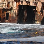
Chapman’s Peak Drive is carved out of the mountainside at the intersection of the Cape granite and sedimentary layers (geologists love this fact), and this can be seen clearly in areas where the mountain isn’t highly vegetated (such in as the photo above). Tony showed me a strange “door in the cliff” – a neat rectangular opening (it seems) that looks like it should be in The Hobbit. You can’t approach it closely on a boat because there’s foul ground in front of it, and the sea is turbulent even when there’s not much swell.

Long Beach is long. There were lovely big waves, with spray unfurling from their tops in the light breeze. We could see horse riders on the beach, surfers in the swell, and at one point right across False Bay to the Hottentots Holland and Hangklip. Further down, the boiler of the Kakapo shipwreck was clearly visible on the sand.

Slangkop lighthouse (pardon the blurry photo) is being painted, it seems – the building is completely clad in scaffolding. This was our turning around point, but first we had coffee and a snack. Boating makes you hungry!

On the way back we stopped a few times to look around (Tony was looking for a whale shark, after NSRI report from St Helena Bay the previous day, and unconfirmed sightings of one in Kommetjie) and dangle our (ok, my) feet in the freezing water. There was an offshore wind blowing. In places the air was freezing cold, and in others the hot wind, smelling strongly of fynbos, made everything wonderfully pleasant.
We took a drive across the mouth of Hout Bay to Duiker Island, where the water looked quite clean. There were snorkelers in the water with the seals. I drove us back from the island (slowly) – I don’t have a skippers licence yet, and in order to get one I need (supervised) hours on the boat. So this was practice.
Once inside Hout Bay harbour, we milled around a bit waiting for the slipway to clear (some poachers were launching, amongst other activity). We came across the Seal Alert boat, which has sunk into disrepair but is a very enjoyable resting spot for some of the local seals. There are also a few boats that have sunk at their moorings – apparently because their drain plugs were stolen.
The middle (bright green) ship in the picture of the fishing vessels moored in the harbour in the above gallery of images, is the sister ship of a ship that ran aground off Betty’s Bay in February, breaking up and spilling huge amounts of fuel near the vulnerable penguin colony.


